
SLIDE 1
Manitoba Infrastructure: Service Delivery Review Manitoba - - PDF document
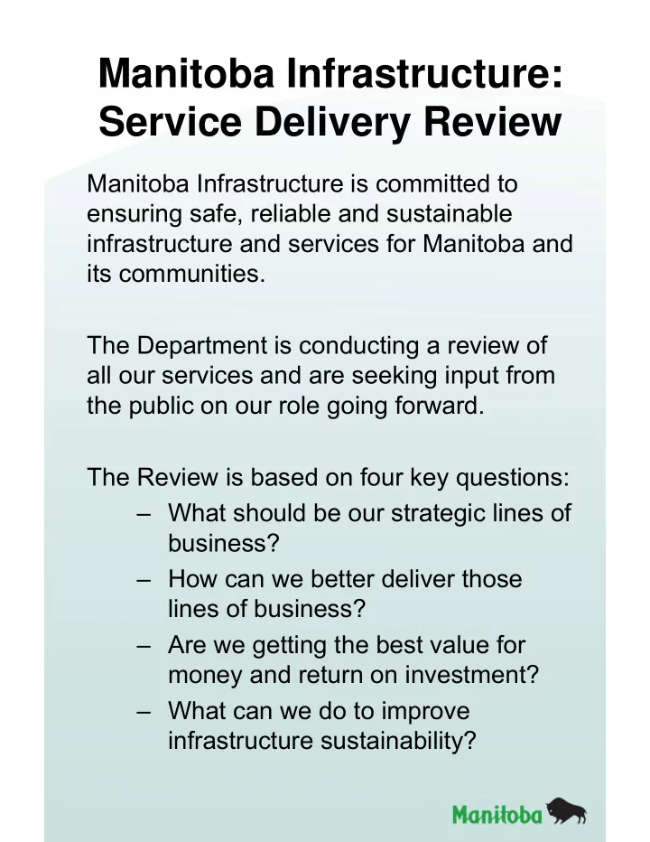
Manitoba Infrastructure: Service Delivery Review Manitoba Infrastructure is committed to ensuring safe, reliable and sustainable infrastructure and services for Manitoba and its communities. The Department is conducting a review of all our
Manitoba Infrastructure is responsible for the delivery of many services:
– Highways: Design, Construction, Maintenance, and Road Information Services – Bridges & Culverts ̶ Water Management – Flood Mitigation ̶ Government Air Services – Drainage Assets ̶ Crown Lands – Hydrologic/Forecasting ̶ Emergency Management – Motor Carrier Services ̶ Disaster Recovery Programs – Northern Airports ̶ Provincial Shortline Railways – Winter Roads ̶ Ferries
Information about five of the major service areas delivered by Manitoba Infrastructure are displayed here today. Please take time to visit each area to learn about the services we currently provide: 1. Infrastructure Construction 2. Infrastructure Maintenance 3. Water Related Assets 4. Motor Carrier Services 5. Emergency Management Staff are available to answer your questions and listen to your comments about any of the services delivered by Manitoba Infrastructure. We also invite you to fill out a comment sheet.
Provincial Trunk Highways
– Are almost always paved – Typically have high traffic volumes – High levels of service in construction and maintenance
Paved Provincial Roads
– Typically have moderate traffic volumes – Moderate levels of service in construction and maintenance
Gravel Provincial Roads
– Lower traffic volumes – Lower levels of service in construction and maintenance
Not all highways or roads are the same; they can be classified based on characteristics:
Strategic highways (mostly paved PTHs)
– Focus: trade and commerce – International, inter-provincial, inter-regional, inter-city
Regionally important highways (mostly paved PRs)
– Inter-municipal, inter-community – Focus: commerce and commuting
Locally important highways (mostly gravel PRs)
– Typically “end of trip” routes: limited through traffic – Focus: access to local businesses, farms and residences
Engineering… Maintenance… Capital project prioritization… Allowable loading
Winter maintenance: Snow and ice control Surface maintenance: Repair potholes, cracks and ruts, base and sub-grade repair, pavement marking, sweeping Gravel maintenance: Distributing, blading, and reshaping gravel roads and gravel shoulders, dust management Roadside maintenance: Culvert repairs, roadside clean-up and drainage management, highway sign maintenance and replacement
roughness, wheel rutting and cracking to determine requirements for surface work.
standards and best practices. The Work Programs generally include surface, shoulders, gravel, roadside, signs and drainage.
Consideration when developing the Capital Program includes:
geotechnical, maintenance, drainage, loading, stakeholder feedback)
limits, focus on strategic highways)
Tender/Contract Types MI Staff Engineering Service Provider Construction Company Preliminary Design Some Some N/A Detailed Design Some Some Some Construction Some None Most Material Supply Some None Most Contract Administration Most Some N/A Quality Control Most Some Some Quality Assurance Most Some None Acceptance Most Some N/A Tender Specifications: Method-based specifications… end-product specifications… performance-based specifications… etc. OPPORTUNITIES TO COMBINE SERVICES IN CONTRACTS? OPPORTUNITIES TO ALTER SERVICE PROVIDER?
Once a capital or maintenance project is prioritized, the department generally tenders the various activities involved in completing the project and enters into a contract with an engineering or construction company
1 INVENTORY: WATER RELATED ASSETS
Flood Protection Community Ring Dikes 19 Pumping Stations 33 Linear River Diking 425 km Diversions 8 Dams 90 Agricultural Drainage Drains 4,750 km Pumping Stations 8 Thru-Dike Culverts 13,000 Culvert Crossings (incl. hwy structures on agricultural drainage network) 3,350 Other Water Control Structures 345
Estimated Asset Replacement Value ~ $7 billion (today’s dollars) INVENTORY: BRIDGES & STRUCTURES ASSETS – 3,365 Structures
Highway Network – 2,439 Structures Highway Structures and Overpasses 1,197 Bridge Sized Culverts 1,059 Overhead Sign Structures 183 Agricultural Drainage Network – 926 Structures Agricultural Drainage Bridges 526 Bridge Sized Culverts 400
Estimated Asset Replacement Value ~ $9 billion (today’s dollars)
1
Provincial Scope Flood Protection
infrastructure operated as a system to protect communities against flooding, including: –Shellmouth Dam and Reservoir –Portage Diversion –Fairford River Water Control Structure –Red River Floodway –Lake Manitoba and Lake St. Martin
–Assiniboine River Dikes (Portage la Prairie to Baie St. Paul)
infrastructure provides a provincial benefit Local Scope Flood Protection (Community ring dikes, pumping stations)
(provincial, municipal and private) –Generally a result of the funding program
–Specific objective to provide community flood protection
–Generally to keep water within channel to avoid uncontrolled overland flooding
–Assiniboine River Dikes (Baie St. Paul to Winnipeg)
Multi-Purpose Dams
safe operation of 90 multi-purpose provincial dams –Water supply (municipal) –Irrigation and stock watering –Recreation –Some flood protection (lower consequence events)
(e.g., inspection, emergency response, design) –Industry requirements and standards due to complexity of asset
plans, operation manuals
benefits Provincial agricultural drainage network
local governments, Conservation Districts and landowners) –Responsibility for drains has varied since the 1800s.
provincial waterways. –3rd order drains and higher (classified based on their capacity) –Includes crossings, small diameter culverts and pumping stations on the agricultural drainage system
benefits
2
Hydrologic Forecasting
forecasts and disseminate information to the public, Emergency officials and municipalities
which can be used by other governmental agencies
Hydrologic Operations
infrastructure
–Approx. 400 stations operated under Canada-Manitoba Cost Share Agreement (MI, MB Hydro, WSC) –MI operates an additional 71 stations
planning and design
3
Development review, LiDAR data collection, and flood hazard maps
in Designated Flood Areas. Provide information on flooding, erosion and/or instability to local authorities
has been acquired and maps are being developed for the lower Assiniboine River, Souris River and other communities
provincial infrastructure
Permit Services
under regulation, by permit.
established by the department as a whole.
not yet been established are reviewed by the departmental Vehicle Weights and Dimensions Steering Committee. Manitoba’s Trucking Productivity Improvement Fund
loads that exceed weight limits on portions of desired routes.
divisional and bridge approvals (as required).
Manitoba’s Safety Fitness Certificate Program
wide by only allowing carriers with appropriate safety performance and insurance levels to operate in Manitoba.
supporting a harmonized approach.
carrier safety performance requirements and need to have an SFC to operate in Manitoba.
Commercial Carrier Facility Audits
hours of service, vehicle fitness and transportation of dangerous goods.
concepts outlining the various requirements and processes.
processes defined by internal program policy. Monitoring of Commercial Carrier Operations
inspection, conviction and reportable accident data incurred by drivers
public web portal.
processes defined by internal program policy. Motor Carrier Enforcement Programs
commercial vehicle surface transportation industry (trucks/buses).
stations) province-wide Activities include enforcement of: weight and dimensions, cargo securement, dangerous goods, hours of service, fuel tax, driver/vehicle licensing and various other regulations. Inspection activities include: Level 1-3 Commercial Vehicle Safety Alliance Inspections, Item specific awareness blitz’s, and cargo verification.
Commercial Carrier Facility Audits
vehicle’s compliance with areas of driver qualification, hours of service, vehicle fitness and transportation of dangerous goods.
defined by internal program policy. Monitoring of Commercial Carrier Operations
conviction and reportable accident data incurred by drivers operating under the carrier.
portal.
defined by internal program policy. Motor Carrier Enforcement Programs
vehicle surface transportation industry (trucks/buses).
province-wide Activities include enforcement of: weight and dimensions, cargo securement, dangerous goods, hours of service, fuel tax, driver/vehicle licensing and various other regulations. Inspection activities include: Level 1-3 Commercial Vehicle Safety Alliance Inspections, Item specific awareness blitz’s, and cargo verification.
Shortline Railway Safety Administration
with existing regulations and inspection requirements.
Traffic Engineering Branch (crossing and signals compliance) and Motor Carrier Commercial Vehicle Safety and Permitting (remaining area’s).
Transport Canada.
Manitoba Emergency Measures Organization (EMO) oversees and coordinates all aspects of emergency preparedness in the province and manages, directs, and coordinates the response of all departments to a major emergency or disaster. Preparedness Program Evaluate emergency preparedness programs to ensure compliance with regulatory requirements for program management, hazard and risk assessments, continuity planning, public education and awareness, emergency preparedness plans, exercises, and other preparedness activities. Deliver emergency management training to meet regulatory requirements and provide emergency management doctrine and supporting material for the emergency management community. Operational Readiness Program Ensure the ability of Manitoba EMO and the Manitoba Emergency Coordination Centre to direct a whole of government approach to emergency and disaster management through maintenance of province-wide situational awareness, preparation and exercising of provincial emergency plans, and delivery of an emergency alerting program. 2007 Elie F5 Tornado 2011 Spring Flood
Disaster Financial Assistance Programs: Manitoba EMO administers and delivers the Manitoba government’s Disaster Financial Assistance program to aid Manitobans in their recovery from natural disasters. 911 Public Safety Answering Points Manitoba EMO provides technical
Public Safety Answering Points in the province. Artificial Flooding Compensation Manitoba EMO administers artificial flooding compensation programs to provide compensation to landowners for damages caused by artificial flooding resulting from the operation
River Floodway.
Manitoba EMO Command Vehicle Sandbagging for 2011 Flood Manitoba Emergency Coordination Centre
Business Continuity Planning Manitoba EMO facilitates the development, exercise and renewal
departmental continuity plans.
To provide and maintain safe, efficient and effective provincial airport and marine infrastructure and services to Manitoba in a reliable and sustainable manner through our innovative, committed and caring workforce.
Our vision is to connect Manitoba’s northern communities by maximizing the safety, efficiency and reliability of Manitoba’s airport and ferry services.
Annually
Annually
Annually
Moved Annually
Ferry Service
by Ferry
Ferry
Emergency Evacuations. Most recent due to Forest Fires in Little Grand Rapids and Pauingassi.
NAMO STATISTICS Connecting Manitobans
C.F. Gilbert Laugher - New marine vessel to provide service for Manitobans to Norway House.