interactive flood simulation
play

Interactive Flood Simulation Project Characteristics flood events - PowerPoint PPT Presentation

Technische Universitt Mnchen Chair for Hydromechanics Chair for Computation in Engineering Interactive Flood Simulation Project Characteristics flood events in alpine areas Modeling: quite frequent Mathematics:


  1. Technische Universität München • Chair for Hydromechanics • Chair for Computation in Engineering Interactive Flood Simulation Project Characteristics • flood events in alpine areas Modeling: • quite frequent Mathematics: • strong impact on human welfare, Programming: agriculture, and industry • 
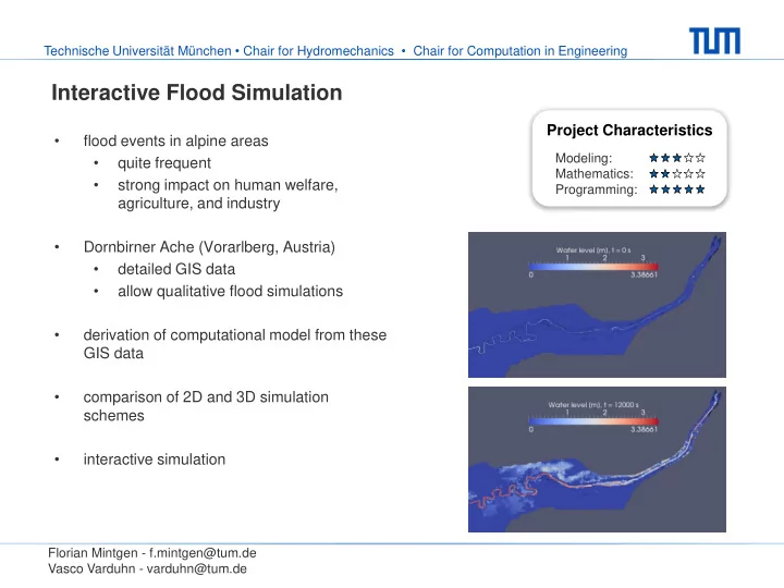
Dornbirner Ache (Vorarlberg, Austria) • detailed GIS data • allow qualitative flood simulations • derivation of computational model from these GIS data • comparison of 2D and 3D simulation schemes • interactive simulation Florian Mintgen - f.mintgen@tum.de Vasco Varduhn - varduhn@tum.de

  2. Technische Universität München • Chair for Hydromechanics • Chair for Computation in Engineering Interactive Flood Simulation Task • import GIS data to VA framework [2] • generate computational grid from imported GIS data • simulation runs with 2D shallow water and 3D fluid codes, OpenFOAM [3] • comparison of the results obtained • main task: Extend your approach for an interactive treatment, i.e. users can manipulate certain parameters (boundary conditions, geometry, etc.) during runtime and get immediate feedback Supervisors Florian Mintgen, Chair of Hydromechanics, f.mintgen@tum.de Vasco Varduhn, Chair for Computation in Engineering, varduhn@tum.de References [1] M. Jud, F. Schwertfirm, C. Rapp, D. Bierhance, M. Schilcher, M. Manhart: Coupling of GIS and Hydraulics using the example of the Dornbirnerach, ESRI User Conference 2011, San Diego, 13.07.2011 [2] http://www.mac.tum.de/wiki/index.php/Project_K2 [3] http://www.openfoam.com Florian Mintgen - f.mintgen@tum.de Vasco Varduhn - varduhn@tum.de

  3. Technische Universität München • Chair for Hydromechanics • Chair for Computation in Engineering Interactive Flood Simulation GIS data 2D mesh 3D mesh simulation time loop boundary conditions, user geometry t -> t+1 store data visualisation Florian Mintgen - f.mintgen@tum.de Vasco Varduhn - varduhn@tum.de

Download Presentation
Download Policy: The content available on the website is offered to you 'AS IS' for your personal information and use only. It cannot be commercialized, licensed, or distributed on other websites without prior consent from the author. To download a presentation, simply click this link. If you encounter any difficulties during the download process, it's possible that the publisher has removed the file from their server.

Recommend


More recommend