INNER LOOP EAST TRANSFORMATION PROJECT Urban Freeways to Boulevards - - PowerPoint PPT Presentation

inner loop east
SMART_READER_LITE
LIVE PREVIEW

INNER LOOP EAST TRANSFORMATION PROJECT Urban Freeways to Boulevards - - PowerPoint PPT Presentation

INNER LOOP EAST TRANSFORMATION PROJECT Urban Freeways to Boulevards Summit Erik Frisch, DES Transportation Specialist June 10, 2014 Orientation Inner Loop East History City population peaked in 1950s at over 330,000 Built in


slide-1
SLIDE 1

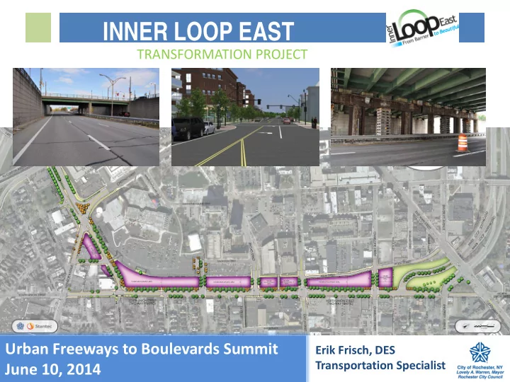
Urban Freeways to Boulevards Summit June 10, 2014

TRANSFORMATION PROJECT

Erik Frisch, DES Transportation Specialist

INNER LOOP EAST

slide-2
SLIDE 2

Orientation

slide-3
SLIDE 3

Inner Loop East – History

  • City population peaked in

1950s at over 330,000

  • Built in late 1950’s and early

1960’s

  • Better Distribute Traffic

Through and Around Downtown

  • Connect to I-490
  • Ultimately complete I-390

extension and Northern Exwy

  • 149 parcels razed

Completion of the Inner Loop in mid 1960’s (looking east at Monroe Ave)

slide-4
SLIDE 4

Inner Loop East – History

Center City - 1930

slide-5
SLIDE 5

Inner Loop East – History

Center City - 1961

slide-6
SLIDE 6

Inner Loop Today

Center City - 2014

slide-7
SLIDE 7

Inner Loop East – Studies

Visions of removal of the Inner Loop

  • The Vision 2000 Plan
  • The Neighbors Building

Neighborhoods Program

  • City of Rochester’s Inner Loop

Improvement Study 2001

  • Center City Master Plan 2003
  • Rochester Regional Community

Design Center – Charrette – A Community Based Vision Plan for Downtown Rochester 2007

  • The Renaissance 2010

Comprehensive Plan

  • GTC Long Range Transportation

Plan 2035

  • Scoping Document 2013
slide-8
SLIDE 8

Why?

  • Reconnect Neighborhoods

with Center City

  • Create Mixed-Use Infill

Development Sites

  • Enhance Bicycle/ Pedestrian

Environment

  • Livability
  • Remedy Mistake of Urban

Renewal Era

slide-9
SLIDE 9

Final Design Recommendation

Proposed Complete Street:

  • Wide sidewalks
  • Two Way Cycle Track w/

Bike Lanes at approaches

  • On-street parking
  • Generous tree canopy
  • 3-4 travel lanes
  • Two-way traffic operations
  • Reconnected City streets
slide-10
SLIDE 10

Recommended Final Design

slide-11
SLIDE 11

Current Status

  • Preliminary Design Complete February 2014
  • Final Design Complete June 2014
  • Construction Begins September 2014
  • Construction Complete Fall 2017
  • First RFPs for Development – Coming Soon
slide-12
SLIDE 12

Phase 2+ ?

  • Extend Highway Removal North and West
  • Better Link Public Market with Center City
  • Reconnect University Avenue
  • Narrow East

Main Street

  • Additional

Mixed-Use Infill Dev.

  • Open Space
slide-13
SLIDE 13

Securing Funding - TIGER

  • TIGER 2013 was third attempt
  • Worked with Stantec (design consultants)
  • $17.7 million request for $23.6 million project
  • Notified August 30, 2013 that project was

selected for full funding

  • Third largest grant given during TIGER 2013 cycle
  • Requires quick turnaround – funds must be
  • bligated by June 2014
  • http://www.advocacyadvance.org/media/blog/wi

nning-tiger-6-funds

slide-14
SLIDE 14

Federal & State Reviews

  • Need new paradigm for urban transportation

impact analyses

  • Vehicle LOS should be de-emphasized on most

urban/inner city projects

  • Multi-Modal LOS
  • Benefit-Cost
  • Economic Development is Valid Purpose
slide-15
SLIDE 15

Statewide Policy Approach

  • New York State can be national leader in

freeways-to-boulevards movement

  • All of our major cities have “Robert Moses disease”
  • Create TIGER-like program in NYS
  • Need more transportation investment at federal

and state levels