Holy Fire Burn Area What to expect this winter Overview of studies - - PowerPoint PPT Presentation

holy fire burn area what to expect this winter overview
SMART_READER_LITE
LIVE PREVIEW

Holy Fire Burn Area What to expect this winter Overview of studies - - PowerPoint PPT Presentation

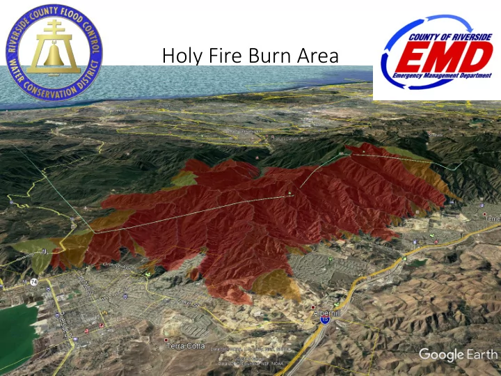
Holy Fire Burn Area What to expect this winter Overview of studies and areas of concern Private property mitigation Debris and mud flow: Fast moving, deadly landslide Travels fast, cant outrun it Its all about rainfall


slide-1
SLIDE 1

Holy Fire Burn Area

slide-2
SLIDE 2
  • What to expect this winter
  • Overview of studies and areas of

concern

  • Private property mitigation
slide-3
SLIDE 3

Debris and mud flow:

  • Fast moving, deadly landslide
  • Travels fast, can’t outrun it
slide-4
SLIDE 4

Can be triggered by rainfall of 0.5” per hour or more of rainfall Rainfall only has to occur for 15 minutes Takes 3-5 years for canyon slopes to stabilize/recover

It’s all about rainfall intensity – not total rainfall

slide-5
SLIDE 5

Corona Canyon Fire 1 aftermath Jan 2018

slide-6
SLIDE 6
slide-7
SLIDE 7
slide-8
SLIDE 8

Other Post Fire Effects

  • Rainfall runoff can be 2 to 5 times higher than

normal, particularly during small storms

  • Ash, burnt smell from first storms of the year
  • Slopes subject to erosion, failure
  • Rockfall from steep slopes
  • Extended road closures, loss of utilities
slide-9
SLIDE 9
  • What to expect this winter
  • Overview of studies and areas of

concern

  • Private property mitigation
slide-10
SLIDE 10
slide-11
SLIDE 11

USGS Builds Debris Flow Models

Chance of Debris Flow Initiating on 1” / hour Rainfall Intensity

slide-12
SLIDE 12

Watershe hed E d Emergenc ncy R Respo pons nse T Team

Hol Holy F y Fire Repor

  • rt

August 30, 2018 www.rivcoready.org/stormready

slide-13
SLIDE 13

CalFire Watershed Emergency Response Team Rapid Assessment of risks to people and property

slide-14
SLIDE 14

Sandpiper Drive

slide-15
SLIDE 15

Indian Creek Glen Eden Sun Club

slide-16
SLIDE 16

Evacuation zones developed by CalFire and the Sheriff

slide-17
SLIDE 17

District Projects McVicker Dam Horsesthief Canyon Leach Canyon Dam

slide-18
SLIDE 18
  • What to expect this winter
  • Overview of studies and areas of

concern

  • Private property mitigation
slide-19
SLIDE 19

Before the Storm

  • Store outdoor furniture and other objects that

could be damaged by storms, thrown by winds,

  • r carried away by water.
  • Cut down weakened trees that could damage

your home.

  • Take care of grading or drainage needs on your

property.

  • Inspect retaining wall drain holes, surface and

subsurface drains and yard drains for signs of

  • bstruction or malfunction.
  • Establish native plants or place other ground cover on bare ground,

slopes or freshly graded areas.

Contact the National Resource Conservation District for assistance - 951.654.7139

slide-20
SLIDE 20

ww www.rivcor

  • rea

eady.org/stor

  • rmrea

eady

  • BAER Report
  • CalFire WERT Report
  • Homeowners Guide
  • Risk and Evacuation Maps
  • AlertRivco Sign-Up
  • Other Current Information
slide-21
SLIDE 21

Information for Homeowners if Subject to Flooding

Standard homeowner policies do not cover flood damage! Purchase Flood Insurance offered by the National Flood Insurance Program (Policy takes 30 days to activate)

1-888-Call-Flood www.floodsmart.gov

slide-22
SLIDE 22

ww www.rivcor

  • rea

eady.org/stor

  • rmrea

eady

slide-23
SLIDE 23

Santa Barbara County- Thomas Fire (3 evacuations, +/- 30,000 people ea.).

There have been 21 reported deaths, Over 150 homes destroyed, 300 more damaged.

Burbank and Sun Valley -La Tuna Fire

A debris flow into a residential area of Sun Valley damaged 40 to 45 homes and carried a vehicle that struck a natural gas pipeline, which began to leak.[36]

Corona - Canyon Fire

covered streets with mud and flooded into several homes, but no major damage has been reported.

Mountain Center – Cranston Fire

1”/hr rainfall from thunderstorms in late August cover portions of Hurkey Creek Park and Lake Hemet Campground with mud and debris. Boulders the size of cars moved further up the watershed near Apple Canyon Road.

2018 Winter Storm and Summer Thunderstorm Season Debris Flow Events

slide-24
SLIDE 24

To Create Interim Risk Maps