Help us create the Henderson-Massey Connections Plan Local boards - - PDF document

help us create the henderson massey connections plan
SMART_READER_LITE
LIVE PREVIEW

Help us create the Henderson-Massey Connections Plan Local boards - - PDF document

Poster one Help us create the Henderson-Massey Connections Plan Local boards across Auckland have been planning and implementing Connections Plans (also referred to as Greenway Network Plans) throughout Auckland over the last 10 years. Having


slide-1
SLIDE 1

Henderson-Massey Connections Plan

www.aucklandcouncil.govt.nz/haveyoursay

Henderson - Massey Local Board

Auckland Council

Help us create the Henderson-Massey Connections Plan

Local boards across Auckland have been planning and implementing Connections Plans (also referred to as Greenway Network Plans) throughout Auckland over the last 10 years. Having consistent connections across Auckland has the potential to transform how people travel every day and how they use the city. The intention of the Connections Plan is to fulfjll some of the aspirations the Local Board outlined in their Open Space Network Plan 2015 - 2025.
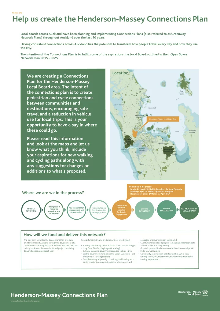
Location

We are here in the process

  • Sunday 24 March 2019 Public Open Day - Te Atatu Peninsula
  • Saturday 6 April 2019 Public Open Day - Westgate
  • Have your say online 27 March - 17 April 2019

Where we are we in the process?

Mana Whenua North West Hui Iwi engagement PROJECT INITIATION Key stakeholder engagement and consultation DESIGN REFINEMENT Connections network updated for Public Engagement Background research, mapping and refjnement DESIGN FINALISATION RATIFICATION BY LOCAL BOARD

Henderson-Massey Local Board Area

Poster one

We are creating a Connections Plan for the Henderson-Massey Local Board area. The intent of the connections plan is to create pedestrian and cycle connections between communities and destinations, encouraging safe travel and a reduction in vehicle use for local trips. This is your

  • pportunity to have a say in where

these could go. Please read this information and look at the maps and let us know what you think, include your aspirations for new walking and cycling paths along with any suggestions for changes or additions to what’s proposed.

The long term vision for the Connections Plan is to build an interconnected Auckland through the development of a comprehensive walking and cycle network. This will take time to fully implement, however individual projects are being delivered across council each year.

How will we fund and deliver this network?

Several funding streams are being actively investigated

  • Funding allocated by the local board, out of its local budget
  • Long Term Plan funding (regional funding)
  • Delivery by central government agencies, such as NZTA
  • Central government funding via the Urban Cycleways Fund

and/or NZTA cycling subsidies

  • Complementary projects by council regional funding, such

as stormwater improvement projects, where access and ecological improvements can be included

  • CCO funding for related projects (e.g Auckland Transport Safe

Schools Travel Plan programme)

  • Goodwill partnerships between council and interested parties
  • Parks renewal budgets
  • Community commitment and stewardship. While not a

funding source, volunteer community initiatives help reduce funding requirements.

slide-2
SLIDE 2

Henderson-Massey Connections Plan

www.aucklandcouncil.govt.nz/haveyoursay

Henderson - Massey Local Board

Auckland Council

L

  • c

a l N e t w

  • r

k

  • O

p e n S p a c e L

  • c

a l N e t w

  • r

k

  • S

t r e e t E x p r e s s N e t w

  • r

k

A connections plan consist of separated and shared path networks that connect neighbourhoods to key destinations such as public transport, schools, local shops, libraries, parks and reserves as well as other community amenities. Paths are either long distance routes, accommodating faster commuter cycling and walking or based around local streets and parks used for local trips and recreation. The layout of the path network is infmuenced by a number of physical barriers such as motorways, busy roads, industrial areas, water bodies and topography. There are however, landscapes that are uniquely suited to the creation of connection path networks. Additionally, there may be existing path networks that need improvement or informal paths that could be

  • pportune for an upgrade.

What is a connections plan?

Poster two

1 , v e h i c l e v

  • l

u m e ( A D T ) :

3

1 5 , + 1 , 1 , 5

4 v e h i c l e s p e e d ( k p h ) : 5 +

r e g i

  • n

a l s c a l e l

  • c

a l / n e i g h b

  • u

r h

  • d

s c a l e

Different types

  • f networks

Grafton Gully Cycleway

Separated Shared Path Express Networks are major cycleways and/or shared paths on busy streets or off-road

  • paths. They connect people to major centres and form the base structure of the network.

Express Network Trail Network

A Trail Network is distinct from a Local Network in that it is found in rural, coastal or bush settings and is primarily for recreation. Many trails will connect to Local or Express Networks, but may also allow for horse-riding alongside walking and cycling. A Trail can also be a bush walk, which due to topography would not be shared with cyclists. Trail networks are not generally intended to form a connection between destinations and often run in loops.

Te Wai O Pareira / Opanuku Stream

Puketapapa Local Path

Local Networks are both on and off-street paths, and are designed to create safe and pleasant neighbourhoods that encourage walking and cycling for local trips. Off-road local paths run through parks and open spaces and accommodate both cyclists and pedestrians. Together with on-street networks, they are designed to create linkages to local centres, parks, schools and transport links including Express networks.

Local Network - Open Space

Puketapapa Local Path Beach Road Cycleway

Separated Cycleway with both directions

Victoria St & Hardinge St, artist impression

Separated Cycleway with Road way (single direction)

Sandringham, Auckland

Local Networks are both on and off-street, and are designed to create safe and pleasant neighbourhoods that encourage walking and cycling for local trips. An on-street local network has pedestrians accommodated on footpaths with streets that are safe enough to cycle on without the need for separated cycle lanes. Traffjc calming tools, pavement marking and signage are used to improved safety for all street users.

Local Network- Street

Sandringham, Auckland Illustrative example illustrative example Illustrative example Illustrative example illustrative example Illustrative example Illustrative example

T r a i l N e t w

  • r

k

slide-3
SLIDE 3

Henderson-Massey Connections Plan

www.aucklandcouncil.govt.nz/haveyoursay

Henderson - Massey Local Board

Auckland Council

Express Network - cross urban connections Local Network - safe streets and shared pedestrian paths linking local destinations Social, ecological and creative connections Local Network - shared paths through open spaces for recreation and local connections

What your connections can look like

Poster three

slide-4
SLIDE 4

Henderson-Massey Connections Plan

www.aucklandcouncil.govt.nz/haveyoursay

Henderson - Massey Local Board

Auckland Council

  • Reduce motor vehicle use for local trips;
  • Link schools ,workplaces and communities with parks,

shops, and transport routes;

  • Reduce the reliance on fossil fuels by providing safe

and attractive alternative transport choices;

  • For communities to engage and connect with each
  • ther and their community facilities;
  • For communities to create a sense of ownership and

pride in their neighbourhoods;

  • Enhance ecosystems, habitat sources and ecological

niches.

  • Biophysical - The steep topography, combined with

a number of streams/creeks, ecological areas and stability of the ground in parts of Henderson-Massey will provide challenges;

  • Infrastructure - Space available within the road

network may not be conducive to the creation of cycle paths.

  • Property ownership - privately owned land parcels

have potential to limit access.

Opportunities Constraints Te Aranga Design Principles

Mana Rangatiratanga - Authority

The status of iwi and hapu as Mana Whenua is recognised and respected

Whakapapa - Names and Naming

Maori names are celebrated

Taiao - The Natural Environment

The natural environment is protected, restored and/or enhanced

Mauri Tū - Environmental Health

Environmental health is protected, restored and/or enhanced

Mahi Toi - Creative Expression

Iwi/hapu narratives are captured and expresses creatively and appropriately

Tohu - The Wider Cultural Landscape

Mana Whenua signifjcant sites and cultural landmarks are acknowledged

Ahi Kā - The Living Presence

Iwi/hapu have a living and enduring presence and are secure and valued within their rohe

Design Principles | Opportunities + Constraints

Poster four

Safe

Safety and a stress-free environment are core principles of achieving a successful Local Path. Confmict points such as high vehicle numbers and high speeds should be minimised by providing a consistent level of experience across the path network. Crime prevention and enhanced social safety are also key outcomes of well-designed Local Paths.

Connected

Local Paths should connect destinations such as residential neighbourhoods, schools and universities, town centres, transit stations, and bicycle facilities. They should seamlessly connect to the wider transport network including Express Paths. Additionally, these connections should be designed to be easily navigated. Where intuitive design is unachievable, clear and consistent way fjnding signage should be employed.

Accessible and Comfortable

Paths infrastructure should be accessible for all users, including children and people with disabilities. Considerations include ample width, gentle gradients, smooth transition in surfaces, and avoidance

  • f high volumes of traffjc that create fumes and noise.

Enabling

Iwi, local community and stakeholders should be engaged early in the process to incorporate Te Aranga principles and community driven initiatives. Local Paths should integrate with the existing streetscape and celebrate Auckland’s unique character by responding to and incorporating elements of the surrounding natural and built environment, heritage and culture. Opportunities to include ecological function through planting, water sensitive design, and low energy/low toxicity materials should be integral to each Local Path design.

Local Path Design Principles

Primarily, local networks must respect the physical and cultural environment and meet the needs of all people walking and cycling. The design framework for the Henderson-Massey Connections Plan is organised under these two headings, the Local Path Design Principles and Te Aranga Design Principles.

slide-5
SLIDE 5

Henderson-Massey Connections Plan

www.aucklandcouncil.govt.nz/haveyoursay

Henderson - Massey Local Board

Auckland Council

Moire Park Zita Maria Park Te Atatū South Park Henderson Valley Park

Sturges Road Candia Road

Fred Taylor Park Kopupaka Reserve Royal Reserve Rush Creek Reserve Massey Leisure Centre Manutewhau Walk St Margarets Park Fitzherbert Reserve Midgley Park Pahi Park West Harbour Reserve Realm Esplanade Lawsons Creek Claverdon Park Spargo Reserve Te Wai o Pareira Taipari Strand Renata Esplanade Tawa Esplanade Hughes Reserve Springbank Esplanade Chapman Rd Te Atatu Peninsula Park Kervil Park Dawnhaven Esplanade Kelvin Strand Spinnaker Strand Waimanu Bay Reserve Jack Pringle Sports Park Ramlea Park Kaumata Reserve Durham Green Harbourview Orangihina Gloria Park Jack Colvin Park McCormick Green Marlene Glade Covil Park Bridge Avenue Reserve Roberts Field McLeod Park Riverglade Esplanade Laurieston Park Valron Esplanade Glendene Reserve Lydford Green Kaikoura Reserve Hart Domain Vitasovich Esplanade Tirimoana Reserve Cron Reserve Divich Reserve Tui Glen Reserve Cranwell Park Pioneer Park Chilcott Brae Coletta Esplanade Epping Esplanade Waitakere City Stadium Henderson Creek Esplanade Sherwood Park Te Pai Park Daytona Reserve Kingdale Reserve Riverpark Reserve Riverpark Reserve Woodside Reserve Helena Park Sunline Park Taitapu Park Lowtherhurst Reserve Colwill Reserve Makora Park Royal Heights Park Fairdene Reserve Glen Norman Reserve Alan Reserve Sun Place Esplanade Reserve Martin Jugum Reserve Paremuka Esplanade Reserve Paremuka Lakeside Paremuka Esplanade Semillon Reserve Harvest Reserve Vintage Reserve Henderson Park Waitakere Central Plumer Domain Shona Esplanade Reserve Border Road Esplanade Murillo Reserve Corban Reserve Palamino Esplanade Forest Hill Park Bruce McLaren Memorial Park Starforth Reserve Oratia Esplanade Sunhill Scenic Reserve Mckinley Park Serwayne Walk Henderson Valley Green Kensington Gardens San Bernadino Reserve Lake Panorama Paremuka Wetland Gus Nola Park Ranui Domain Pooks Reserve Marinich Reserve Starling Park Armada Reserve Elvira Walk Hamblyn Reserve Te Rangi Hiroa/ Birdwood Winery Don Buck Corner Reserve Urlich Esplanade Reserve Massey Domain Triangle Park Emerald Valley Park Gallony Park Raelene Reserve Reynella Reserve Lincoln Park Esplaande Reserve Lincoln Park Cartmel Reserve Kemp Park Cyclarama Reserve McClintok Reserve Westgate Drive Park

State Highway 16 Wharf Road Beach Road Te Atatu Road Universal Drive Triangle Road

C e n t r a l P a r k D r i v e

S w a n s

  • n

R

  • a

d Lincoln Road Sturges Road Swanson Road Henderson Valley Road Edmonton Road G r e a t N

  • r

t h R

  • a

d Te Atatu Road B r u c e M c L a r e n R

  • a

d Forest Hill Road View Road Triangle Road Royal Road M a k

  • r

a R

  • a

d D

  • n

B u c k R

  • a

d Hobsonville Road Fred Taylor Drive T r i g R

  • a

d L u c k e n s R

  • a

d Moire Road State Highway 18

Future arterial road / cycleway Indicative openspaces P

  • t

e n t i a l b u s / c y c l e r

  • u

t e K e y c y c l e r

  • u

t e

MASSEY WESTGATE ROYAL HEIGHTS WEST HARBOUR LUCKENS POINT WHENUAPAI HOBSONVILLE TE ATATŪ PENINSULA LINCOLN RANUI BIRDWOOD SWANSON STURGES TE ATATŪ SOUTH HENDERSON WESTERN HEIGHTS GLENDENE SUNNYVALE GLEN EDEN KELSTON NEW LYNN

RAIL CORRIDOR CYCLEWAY

N O R T H W E S T C Y C L E W A Y

PROJECT TWINSTREAMS CYCLE CIRCUIT CONNECTION Redhills Precinct Plan Te Atatū South Town Centre Plan Integrated Corridor Study H e n d e r s

  • n

S t u d y A r e a

1 _ Paths currently within the planning and/or construction phase. 2 _ Existing paths that need repair and/or upgraded to allow for additional capacity. 3 _ Paths proposed to improve network connectivity and/or with a high degree of commitment . 4 _ Aspirational projects proposed by the community or local board.

Express Network Local Network-Street Local Network-Open Space Trail Network

PATH TYPE

KEY

Existing Planned1 Improved Level Service2 Proposed3 Aspirational4

PATH TYPE STATUS

DRAFT-Henderson-Massey Connections Plan

Poster fjve Local board boundary Parcel boundaries Road network Recreational areas Special project areas Fixed intersection

slide-6
SLIDE 6

Henderson-Massey Connections Plan

www.aucklandcouncil.govt.nz/haveyoursay

Henderson - Massey Local Board

Auckland Council

The Henderson-Massey Local Board is creating a connections plan, which will help guide the development of our walking and cycling paths in the future. We want people to be able to get from home to their destinations, be it school, work, shopping or parks easily, safely and without having to use a car. We want you to have your say on our draft plan, to let us know what works, what doesn’t and what there should be more of.

Poster six

What do you think about the overall plan? Do you support it in principle? (Yes/No) Do you have any suggestions that could improve the plan in general? (things like missing routes, different types of paths or new destinations) Thinking about your routes, which key connections would support you to walk and/or cycle to areas where you live, work, learn and/or play Is there any other feedback you have about this plan?

Key Questions