
SLIDE 1
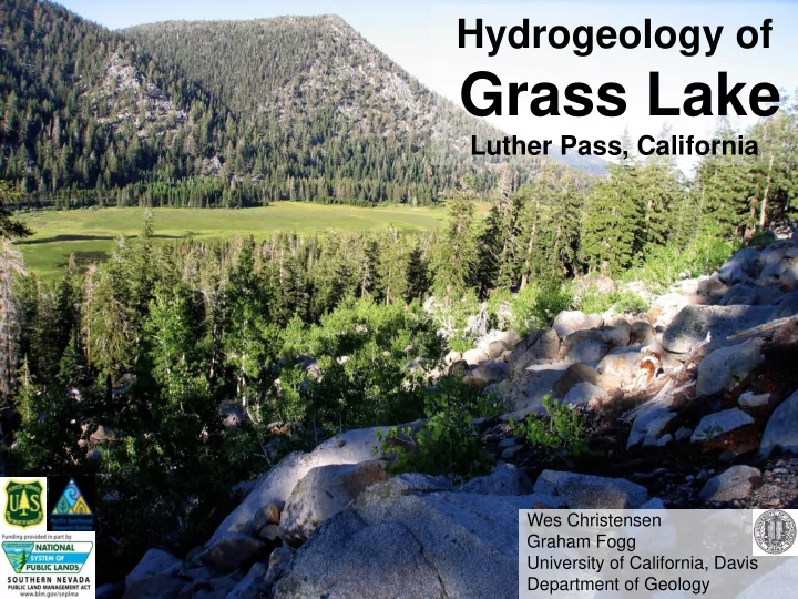
Hydrogeology of Grass Lake
Luther Pass, California
Wes Christensen Graham Fogg University of California, Davis Department of Geology
Grass Lake Luther Pass, California Wes Christensen Graham Fogg - - PowerPoint PPT Presentation
Hydrogeology of Grass Lake Luther Pass, California Wes Christensen Graham Fogg University of California, Davis Department of Geology Overview Site description Geology Stream flows Hydraulic gradients Specific conductivity
Wes Christensen Graham Fogg University of California, Davis Department of Geology
– Geology – Stream flows – Hydraulic gradients – Specific conductivity
– Parameter estimations and measurements – Geomorphic basis for geologic unit thickness
groundwater sustained peatland (Grass Lake) to predicted changes in climate – Earlier snow melt – Less snow, more rain on snow
– Local scale hydrology (~100 m2)
groundwater flow and storage – Hydraulic conductivity – Storage coefficients – Thicknesses of geologic units
– NO tracer tests – NO pumping – Minimal disturbance – Natural T signal
– Recessional and lateral moraines
– Terminal and cirque moraines
entering Grass Lake – Associated with Tioga age glacial cirques
channels in upper WS
10 20 30 40 50 60 70 80 4/20 5/20 6/19 7/19 8/18 9/17 10/17 Flow (cfs) Date
Grass Lake Outlet
2010 2011
2 4 6 8 10 12 4/20 5/20 6/19 7/19 8/18 9/1710/17 Flow (cfs) Date
First Creek
2010 2011 0.5 1 1.5 2 2.5 3 3.5 4 4.5 4/20 5/20 6/19 7/19 8/18 9/1710/17 Flow (cfs) Date
Waterhouse Creek
2010 2011 0.00 1.00 2.00 3.00 4.00 5.00 6.00 4/20 5/20 6/19 7/19 8/18 9/1710/17 Flow (cfs) Date
W Freel Meadows Creek
2010 2011 5 10 15 20 25 30 35 4/20 5/20 6/19 7/19 8/18 9/1710/17 Flow (cfs) Date
Freel Meadows Creek
2010 2011
– WH Ck and WFM Ck slightly longer recession
GW SW
Date N1 N2 N3 N4 N5 N7 N8 N9 N10 N11 N12 N13 N14 N15
vertical distances
hillslope/confined aquifer through the peat
S1 S3 S4 S5 S6 S7 S8 S9 S10 S11 S12 S13 S14 S15
0.0 0.1 0.2 0.3 0.4 4/20 6/19 8/18 10/17 Hydraulic Gradient (m/m) Date 2010
2010 (S)
0.0 0.1 0.2 0.3 0.4 4/20 6/19 8/18 10/17 Hydraulic Gradient (m/m) Date
2011 (S)
0.0 0.1 0.2 0.3 0.4 4/20 6/19 8/18 10/17 Hydraulic Gradient (m/m) Date 2011
2011 (N)
0.0 0.1 0.2 0.3 0.4 4/20 6/19 8/18 10/17 Hydraulic Gradient (m/m) Date 2010
2010 (N)
– 0.1 to 0.9m change in N – 0.1 to 0.3m change in S Fall 2010 Piezometric Head Spring 2011 Piezometric Head
0.0 20.0 40.0 60.0 80.0 100.0 120.0 140.0 160.0 180.0 2/26 4/17 6/6 7/26 9/14 11/3 Specific Concutivity (uS/cm) Date 2011
SC: Streams 2011
1st Creek WFM Creek FM Creek WH Creek Outlet 0.0 20.0 40.0 60.0 80.0 100.0 120.0 140.0 160.0 180.0 4/17 6/6 7/26 9/14 11/3 Date 2011
SC: Piezometers 2011
N11 N5 S8 S3 N11 SW N5 SW S8 SW S3 SW
– Can be determined using vertical T profiles and head
N7: T(t) at different depths 5 10 15 20 25 7/26/11 7/27/11 7/28/11 7/29/11 7/30/11 7/31/11 8/1/11 8/2/11 Date Temperature (C)
r=0cm, z=10.8cm r=22.4cm, z=10.2cm air T
r (m) r (m)
decomposed sample
0.00 0.50 1.00 1.50 2.00 0.00 0.50 1.00 suction (m) volumetric water content (%) Grass Lake Peat Retention Curves PC1 PC2 PC3 PC4
– 80+m thick weathered bedrock (grus)
– 5 to 40m thick glacial till
– 80m thick valley fill (peat surface to bedrock)
– 0 to 10m thick peat
http://dx.doi.org/10.5069/G9PN93H2
Hydrogeosphere Fully coupled SW-GW flow 1m of surface recharge Drain for 6 month
– David Immeker – Sarah Howell – Shana Gross
– Nick Newcomb – Nick Engdahl – Dylan Boyle – Ehsan Rasa – Charlie Paradis