Global and local surface albedo : results from the ESA GlobAlbedo, - - PDF document

global and local surface albedo results from the esa
SMART_READER_LITE
LIVE PREVIEW

Global and local surface albedo : results from the ESA GlobAlbedo, - - PDF document

Global and local surface albedo : results from the ESA GlobAlbedo, EU-QA4ECV and EU-JRC-GbOV projects Jan-Peter Muller, Rui Song, Said Kharbouche (UCL-MSSL) P. Lewis (UCL Geography), Olaf Danne (Brockmann Consult), Yves Govaerts (Rayference),


slide-1
SLIDE 1

Global and local surface albedo : results from the ESA GlobAlbedo, EU-QA4ECV and EU-JRC-GbOV projects

Jan-Peter Muller, Rui Song, Said Kharbouche (UCL-MSSL)

  • P. Lewis (UCL Geography), Olaf Danne (Brockmann Consult),

Yves Govaerts (Rayference), Jörg Schultz, Marie Doutriaux- Boucher, Alessio Lattanzio, Youva Aoun (EUMETSAT)

QA4ECV has received funding from the EU-FP7 Programme under no. 607405

International Solar Energy Society webinar, 20 November 2018

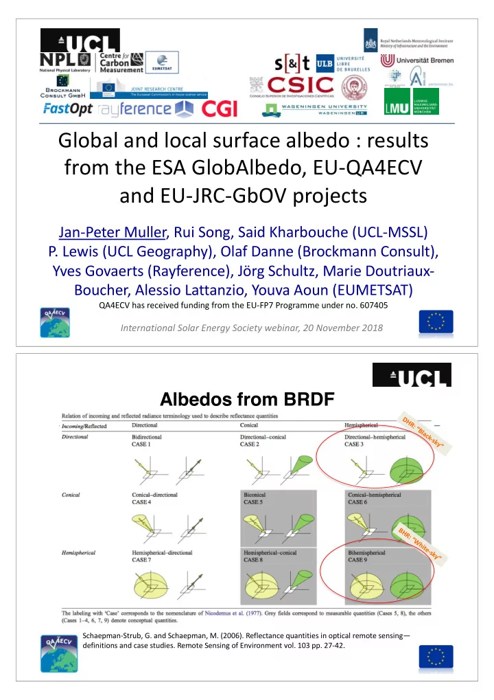
Schaepman-Strub, G. and Schaepman, M. (2006). Reflectance quantities in optical remote sensing— definitions and case studies. Remote Sensing of Environment vol. 103 pp. 27-42.

DHR: “Black-sky” BHR: “White-sky”

Albedos from BRDF

slide-2
SLIDE 2

3

Polar-orbiting satellites for land surface science: 1980s – 1990s data poor, 2000s-data rich

Albedo Production : Input data streams

AVHRR 35 year time period LTDR v5.2, Courtesy of E. Vermote (UMD)

www.GlobAlbedo.org

CSIRO seminar, Canberra, 1 August 2013

GlobAlbedo 8-daily 2006 SW BHR (1998-2011) used MODIS, MERIS and VEGETATION

slide-3
SLIDE 3

GEO BRF

Ø BRF processed from GSA products (Single channel and Broadband)

Broadband BRF processed from all 5 satellites. Corresponding date : 2000-02-28T

Broadband Daily Albedo (1982-2016)

http://www.qa4ecv.eu/ecv/albedo/avhrrgeo To explore all the individual components

Traceability diagram availability for all products

slide-4
SLIDE 4

MODIS Collection 6 Daily Climatology

“True” Colour climatology of 26 years of daily MODIS 7 spectral albedos JASMIN is a world leading, unique hybrid of:

  • 18PB high performance storage (>250GByte/s)
  • High-performance computing (>6,000 cores)
  • 40PB Archive and Elastic Tape
  • Non-blocking Networking (> 3Tbit/sec),

and Optical Private Network WAN’s

  • Coupled with cloud hosting capabilities
  • (Jonathan Churchill, Jasmin Conference, June 2017)

Dedicated to QA4ECV project:

  • Memory: +750TB
  • Cores: [400, 2000]
  • Broad Band Albedo
  • 10.5 Tb inputs
  • 2 compute days/yr GLOBAL
  • Spectral Albedo
  • 11Tb inputs
  • 3 compute days/yr Europe
  • MISR Sea-ice spectral albedo
  • 30Tb inputs,
  • 0.5 compute days/yr Arctic
  • Product sizes:
  • 6 Tb (35 years daily)
  • 0.05Tb (4 years daily)
  • 12 Tb (16 years)

Albedo: Production at JASMIN@Harwell

slide-5
SLIDE 5

AVHRR+GEO(Tri-spectral BHR) Inter-comparison on a global scale

N.B. QA4ECV has better coverage of bright regions cf GlobAlbedo 15-Apr-1998 20-Jul-1998

slide-6
SLIDE 6

20km

Field Radiometer (Parabola), 24Jun2014 Airborne Radiometer (CAR), 16May2008 Altitudes (over surface): ~200m ~645m ~1480m ~3400m 20k m

Calibration site: Railroad Valley Playa, Nevada, US

Landsat 7 Modis

Understanding the effects of scale from field to aircraft to EO satellite in surface bi- directional reflectance.

CAR vs Landsat7 CAR vs MODIS CAR vs MISR

Kharbouche, Muller et al., Remote Sensing (2017)

www.GlobAlbedo.org

CSIRO seminar, Canberra, 1 August 2013

GlobAlbedo 8-daily BHR for Hainich marked in Google Earth Tower sites across the world employed albedometers to measure shortwave albedo to compare against satellite- derived albedo

slide-7
SLIDE 7

CSIRO seminar, Canberra, 1 August 2013

www.GlobAlbedo.org BSRN Toravere: footprint covers multiple land cover types

N.B. Very noisy tower albedometer data, much higher values from tower cf all other EO values

14

Tower albedometer instrumentation at 70m

Photos of 70m Tumbarumba Flux tower, and configuration of the albedometers (extreme right). Courtesy of Dr William Woodgate, CSIRO Australia

slide-8
SLIDE 8

15

Surface albedo from tower measurements

Typically, in-situ measurements of Blue-Sky (or clear sky) albedo are used to validate surface albedo from satellite observations over homogeneous sites. Here BHR and DHR are used to validate surface albedo in an indirect way. !"#$%&'(")$*+ = - ∗ !/0 + 1 − - ∗ 4/0

16

Example of in-situ Tower BHR production

A sample of processed FLUXNET Tumbarumba tower data for in-situ BHR production

β

slide-9
SLIDE 9

17

Example of in-situ Tower DHR production

An example of processed FLUXNET Tumbarumba tower data showing the production of in situ DHR.

β β

18

Upscaling Albedo to Satellite (1km) pixel size

  • ver a heterogeneous site

High-resolution DHR and BHR are not directly available from satellite

  • bservations. So we need to employ surrogates for upscaling.

Processing chain to calculate high-resolution albedo from HR-EO surface reflectance and MODIS BRDF data.

DHR at Sentinel resolution BHR at Sentinel resolution

slide-10
SLIDE 10

19

Validation of upscaled Albedo

Comparison between upscaled DHR and DHR derived from the MODIS BRDF function, at DE-HAI site.

Land Albedo – Summary

  • Long time series satellite-derived broadband and

spectral albedo products available from fusing US and European polar orbiting and geostationary platform data

  • All EO products available through UK CEDA and in future

through the EU Climate Data Store with QA defined through EU-EQC

  • Operational system (http://gbov.copernicus.acri.fr/) to

provide validation data over heterogeneous surfaces using tower platforms with shortwave albedometers

  • Moving towards a tower-based hyperspectral BRF

system to achieve the same for spectral BRDF/albedo