Foo oothill thill Roa oad (D (Del elta ta Wate ters Rd. . to - - PowerPoint PPT Presentation

foo oothill thill roa oad
SMART_READER_LITE
LIVE PREVIEW

Foo oothill thill Roa oad (D (Del elta ta Wate ters Rd. . to - - PowerPoint PPT Presentation

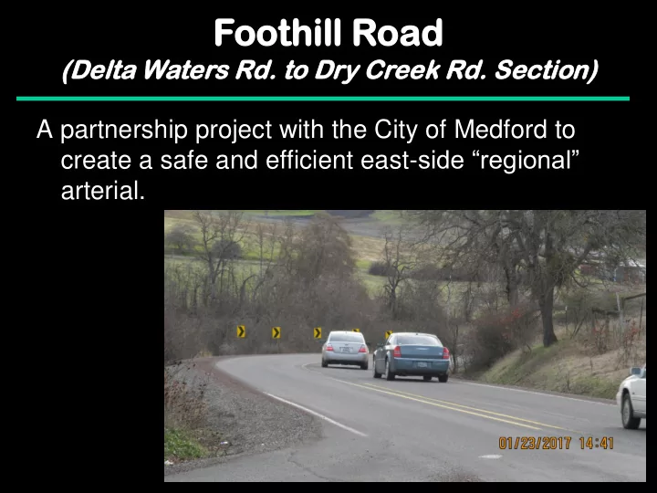
Foo oothill thill Roa oad (D (Del elta ta Wate ters Rd. . to to Dr Dry Cr Cree eek Rd. Se Sect ction) on) A partnership project with the City of Medford to create a safe and efficient east- side regional arterial. Foo


slide-1
SLIDE 1

Foo

  • othill

thill Roa

  • ad

(D (Del elta ta Wate ters Rd. . to to Dr Dry Cr Cree eek Rd. Se Sect ction)

  • n)

A partnership project with the City of Medford to create a safe and efficient east-side “regional” arterial.

slide-2
SLIDE 2

Foo

  • othill

thill Roa

  • ad

(D (Del elta ta Wate ters Rd. . to to Dr Dry Cr Cree eek Rd. Se Sect ction)

  • n)

Problem: Foothill Road is currently a very sub- standard facility to carry current and future traffic

  • Lack of N-S arterial routes in the valley
  • I-5 being used as a local road
  • No good detour for emergencies
  • Poor vertical and horizontal alignment
  • Little or no shoulders – very unforgiving road
  • Increasing ADT’s (currently 8100 N. of Coker Butte Rd.)
  • High crash rate
slide-3
SLIDE 3

Foo

  • othill

thill Roa

  • ad
slide-4
SLIDE 4

Foo

  • othill

thill Roa

  • ad

(D (Del elta ta Wate ters Rd. . to to Dr Dry Cr Cree eek Rd. Se Sect ction)

  • n)
slide-5
SLIDE 5

Foo

  • othill

thill Roa

  • ad

(D (Del elta ta Wate ters Rd. . to to Dr Dry Cr Cree eek Rd. Se Sect ction)

  • n)
slide-6
SLIDE 6

Foo

  • othill

thill Roa

  • ad

(D (Del elta ta Wate ters s Rd. . to to Dr Dry Cr y Cree eek Rd. Se Sect ction)

  • n)
slide-7
SLIDE 7

Foothi thill ll Road

(D (Del elta ta Wate ters s Rd. . to to Dr Dry Cr y Cree eek Rd. Se Sect ction)

  • n)
slide-8
SLIDE 8

Foo

  • othill

thill Roa

  • ad

(D (Del elta ta Wate ters Rd. . to to Dr Dry Cr Cree eek Rd. Se Sect ction)

  • n)

Project Summary

  • 6800 feet long
  • Add 7-foot shoulders (shared shoulder/bike lane)
  • Left-turn lanes at Devils Garden Rd., Coker Butte
  • Rd. and Dry Creek Rd. intersections
  • Improve alignment at selected locations to

address sub-standard vertical and horizontal curves (45 mph design speed)

slide-9
SLIDE 9

Begin Project End Project

slide-10
SLIDE 10
slide-11
SLIDE 11
slide-12
SLIDE 12

Budget and Funding

(current dollars)

CMAQ Awarded $ 755,652 STBG Awarded $1,255,652 County Match (10.27%) $ 287,430 Additional CMAQ Request $ 645,000 Additional Match (10.27%) $ 73,823 Over-Match $ 281,177 Total Project Cost: $3,298,734

Footh

  • thill

ill Road ad

(D (Del elta ta Wate ters s Rd. . to to Dr Dry Cr y Cree eek Rd. Se Sect ction)

  • n)
slide-13
SLIDE 13

Safety Summary

Foothi thill ll Road

(D (Del elta ta Wate ters s Rd. . to to Dr Dry Cr y Cree eek Rd. Se Sect ction)

  • n)
  • 34 reported crashes over the last 5 years (2011 - 2015).
  • 12 at intersections (many rear-end accidents waiting for a left-turn)
  • 20 run off the road and 2 other
  • 18 injury and 15 PDO
  • One fatality
  • The proposed project should address 30 of the 34

reported crashes

  • 10 of the intersection crashes likely prevented if left turn lanes

were present.

  • 7-foot shoulders and better alignment may have prevented the 20

run off the road crashes.

slide-14
SLIDE 14

New Criteria

Foothi thill ll Road

(D (Del elta ta Wate ters s Rd. . to to Dr Dry Cr y Cree eek Rd. Se Sect ction)

  • n)
  • LTS = 2, based on 45 MPH rural facility with 7-foot

shoulders.

  • Emission Reductions:
slide-15
SLIDE 15

Questions?

Foothi thill ll Road

(D (Del elta ta Wate ters s Rd. . to to Dr Dry Cr y Cree eek Rd. Se Sect ction)

  • n)

Fatal Crash Site