Event #3 3000 Discharge (cfs) Turbidity (FNU) ~4 days SSC (mg/L) - - PowerPoint PPT Presentation
Sampling Location: Fruitland Bridge 4000 120,000 100,000 Event #3 3000 Discharge (cfs) Turbidity (FNU) ~4 days SSC (mg/L) 80,000 2000 60,000 40,000 1000 Jeb Brown 20,000 JebBrown@usgs.gov 0 0 9/27 9/28 9/29 9/30 10/1 10/2
Julie Korak JKorak@usbr.gov Jeb Brown JebBrown@usgs.gov
Discharge (cfs) Turbidity (FNU) SSC (mg/L)
Event #3 ~4 days
20,000 40,000 60,000 80,000 100,000 120,000 1000 2000 3000 4000 9/27 9/28 9/29 9/30 10/1 10/2 Date
Sampling Location: Fruitland Bridge
A R S E N I C
- ALL Ag and canal sediment met Ag Guideline
- ALL River sediment met Aquatic and Residential Guidelines
L E A D
- ALL Ag soil met Residential Guideline
- Nearly ALL Ag soil met Ag Guideline
- ALL canal sediment met Ag and Residential Guidelines
- Nearly ALL River sediment met Aquatic Guideline
BEWARE NEED MORE INFO OK
SOIL & SEDIMENT RESULTS
By K. Chief, Assoc Prof & Ext Sp.
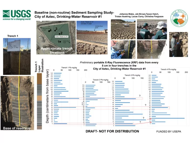
1 2 3 4 5 6 7
Human1Bacteria Quantification San Juan River at Hogback had significantly higher human bacteria than all other sites
Jaclynn Fallon, San Juan Watershed Group
Navajo-Gallup Water Supply Project
Research Focus Area
- Reaches: 12.1, 12.2, & 22
Features
- 280 miles of pipeline
- 2 treatment plants
- Several pumping plants
2 Laterals
- San Juan (red line)
- Cutter (yellow & green)
Bernadette Fontenelle
The Holy Corn Pollen Path and the Gold King Mine Spill
“We as Navajo people view all things as having life and draw no distinction between the abiotic and
- biotic. In our holy songs we sing about being
children of the earth. We were made from ears of corn and the big wind gave us life. Water is revered and held sacred. The rivers carry our prayers and are integral part of ceremonial
- life. When the Gold King Mine Spill happened it
affected a holy part of our world, the San
- Juan. We watched our children, the corn and
plants die. We need the water and plants in our ceremonies to restore balance and harmony to our
- world. Without being sure of the sanctity of our
water and plants, our holy corn pollen path has been disrupted. That why I believe our work is vital to revitalizing our farming way of life and reconnecting to our Mother the Earth. Hózhó.” Brandon Francis NMSU Agricultural Science Center
Particle-bound Metals in San Juan Watershed
Time Magazine Steve Austin, NNEPA
Piedra River San Juan River Lake Powell UT AZ CO NM Animas River Los Piños River Chaco Creek La Plata River McElmo Creek Mancos River Chinle Creek
Steve Austin, NNEPA
San Juan River Delta Logan Frederick, University of Utah
"
"
! ( ! ( ! ( ! ( ! ( ! ( ! ( ! ( ! ( ! ( ! ( ! ( ! ( ! (
£ ¤
5 5
5727.34
Inca
5739.21 5728.46 5733.92 5725.31 5729.98 5739.59 5731.62 5723.55 5729.28 5736.54 5734.37 5740.39 5754.51 5732.03 5 7 3 5 5730 5 7 2 5 5760 5740 5780 5 7 2
107°55'W 107°56'W 107°57'W 237,000 238,000 239,000 240,000 4,086,000 4,087,000 4,088,000
/
B
0.2 0.4 0.6 0.8 1 mi
"
"
! ( ! ( ! ( ! ( ! ( ! ( ! ( ! ( ! ( ! ( ! ( ! ( ! ( ! (
! ! !
£ ¤
5 5
5727.34
Inca
5728.92 5732.84 5723.61 5724.86 5724.33 5721.88 5718.16 5720.67 5736.3 5722.55 5727.34 5735 5730 5725 5760 5 7 4 5780 5720 5700
107°55'W 107°56'W 107°57'W 237,000 238,000 239,000 240,000 4,086,000 4,087,000 4,088,000
/
B
0.2 0.4 0.6 0.8 1 mi
- Most of Animas River has gaining
conditions.
- Seasonal fluctuations in river stage
and water levels are enough to reverse groundwater/ surface water flow direction.
- Potential for future contamination from
lingering sediments, and reversals in groundwater flow
- The river and the groundwater in the
valley are hydrologically connected.
- The irrigation ditch water is feeding
the shallow water table, recharging groundwater during the irrigation season.
- Potential pathway for contamination to
enter aquifer
GROUNDWATER LEVEL MONITORING
along the Animas River, New Mexico, after the Gold King Mine 2015 mine-water release
Ethan Mamer, Talon Newton, Stacy Timmons
Fall water table Spring water table
Ethan Mamer
What happens to stream algae on the Animas during critical low flows?
Nitrogen & Phosphorus
+
Cultural Eutrophication
Nutrients “fertilize” the river Algal Blooms Die off & Decomposition Reduced Dissolved Oxygen Death of fish & aquatic species
Low flow = less water to dilute pollutants “Critical low flow” = 88.8cfs Annual Minimum flows on Animas @ Aztec 2008-2018 Range <10 to 150 cfs
7/1/12 190 cfs 6/13/18 320 cfs Melissa May
1 2 3 4 5 6 7 8 9 0.01 0.1 1 10 100 1000
NAGpH NPR
Combined ARD Classification Plot
Jeter Mine Rosedale District Jicarilla District Silverton, CO
- St. Anthony Mine
Little Davie, Lucky Don, Chupadera
UNCERTAI N NON- ACID FORMING POTENTIAL ACID FORMING UNCERTAIN
Acid Rock Drainage (ARD) plot of waste rock pile at mines examined during the NMBGMR AML project. NPR is a calculated ABA parameter
MINERALOGY AND CHEMISTRY OF MINE WASTE ROCK PILES IN MINING DISTRICTS IN SOUTHERN COLORADO AND NEW MEXICO
Perform a holistic assessment of contaminants and risks Challenging issues for communication: regulatory and technical nomenclature, measurement units, valence states, isotopes, numerous standards and guidelines, background contamination, language barriers GKM potential exposure pathways: drinking surface or groundwater, swimming/boating, sediment exposure, ingestion of crops, livestock, fish, wildlife, airborne dust Communicate using simple terms, without being condescending, that directly address public questions and concerns
Communicating Environmental Risks to the Public
Dennis McQuillan, New Mexico Environment Department
11
Geochemistry the of the Animas River after the Gold King Mine Spill, San Juan County, New Mexico
Talon Newton, Ethan Mamer, Stacy Timmons
- Groundwater recharge sources
- River water via irrigation
- Regional groundwater
- Iron and Manganese
- Exceeds U.S. EPA secondary
MCL in some wells
- Difficult to pinpoint the
source
- Gold King Mine spill
- No evidence of impact to
groundwater quality
- Favorable geochemical
conditions
- Potential for impact still exists
- Ongoing monitoring is
recommended
Water Quality in the Animas and San Juan Rivers Post Gold King Release--Updated with 2017 Water Sampling
Kate Sullivan, Mike Cyterski Office of Research and Development, US Environmental Protection Agency, Athens, GA
BACKGROUND
- The Gold King Mine release mainly affected water and sediment metals in the Animas during the first month
after the release (August 2015)
- The San Juan River did not receive much of the release at that time because most of it was deposited upstream
- f Durango
- EPA’s science team found that these deposits were washed out of the Animas and transported to Lake Powell
during the 2016 snowmelt period from March to June (see EPA report 2016 on the Gold King website)
- We sampled during snowmelt 2017 to confirm that everything had returned to background
RESULTS
- In 2017, many metals in the Animas were the lowest in years
- We don’t have as long a record of metals concentrations in the San Juan, but metals were also very low
throughout the river in 2017
- We developed sensitive indicators of when the GKM metals were carried in the rivers--none were found
in 2017
- Metals were within safe use levels
Scott Roberts, Mountain Studies Institute – scott@mountainstudies.org
Animas River – Aquatic Insects
Predator
soil
sediment
Bottom-feeder
M+ detritivores
scrapers Dissolved
- rganic C
M+ M+
predators
periphyton terrestrial vegetation
Heavy metal cycling through Animas River
- rganisms 2-years after the Gold King Mine spill
Daniel Cadol and Benjamin Duval, NMT
Leaves Corn
Metal concentrations in leaf tissue
Location-Navajo Nation