SLIDE 1 Evaluation of Flood Mitigation Function of the Van Coc Lake in a Catastrophic Flood Event of the Red River, Northern Vietnam
Sai Hong Anh1,3, Toshinori Tabata2*, Kazuaki Hiramatsu2, Masayoshi Harada2
1Department
Agro-environmental Sciences, Graduate School
Bioresource and Bioenvironmental Sciences, Kyushu University, 744 Motooka, Nishi-ku, Fukuoka 819-0395, Japan
2Department of Agro-environmental Sciences, Faculty of Agriculture, Kyushu University, 744
Motooka, Nishi-ku, Fukuoka 819-0395, Japan
3Division for Water Resources Planning for the North Region, Institute of Water Resources
Planning, 162A-Tran Quang Khai, Hoan Kiem, Hanoi, Vietnam *Corresponding author. E-mail: ttabata@bpes.kyushu-u.ac.jp Abstract The Van Coc Lake is a regulating reservoir located in the Dan Phuong and Phuc Tho Districts (30km from the center of Hanoi Capital). In emergency situations, floodwater from the Red River is discharged through the Van Coc Gate and the overflow point on the bank to the downstream through Day Weir. However, the flood mitigation function of the Van Coc Lake in emergency situations to minimize flood risk levels to residential areas located outside protected areas of the Red River dike system (the river area inside the dike system) has not been adequately addressed. In this study, a two-dimensional depth-averaged hydrodynamic model and the latest digital elevation map were utilized to evaluate the flood mitigation function of the Van Coc Lake in the emergency
- situation. The results of our analyses showed that the lake was a useful regulating reservoir to
protect the Hanoi Capital in flood disaster events. However, the residential areas were inundated with 96.0 % (38.0 km2) of the total residential areas vulnerable to flood disasters. This study is aimed at being a foundation for further research on designing flood risk-reduction strategies in Hanoi Capital. Keywords: Two-dimensional depth-averaged hydrodynamic model, flood risk management, flood risk level, flood disaster, hazard map INTRODUCTION The Red River is the largest river in the north of Vietnam and runs through the Hanoi Capital. Nowadays, the river faces challenges from floods and drought, especially in the context of climate change and rural development (MONRE, 2012). Flood is generally characterized by a rapid increase in the river water level, and the flood season in the Red River system occurs from May to September with 3–5 annual floods in the basin (AHA Centre & JICA, 2015). In 1971, the flood was
- ne of the 10 worst floods of the 20th century. A total of 100,000 people died in this disaster
SLIDE 2
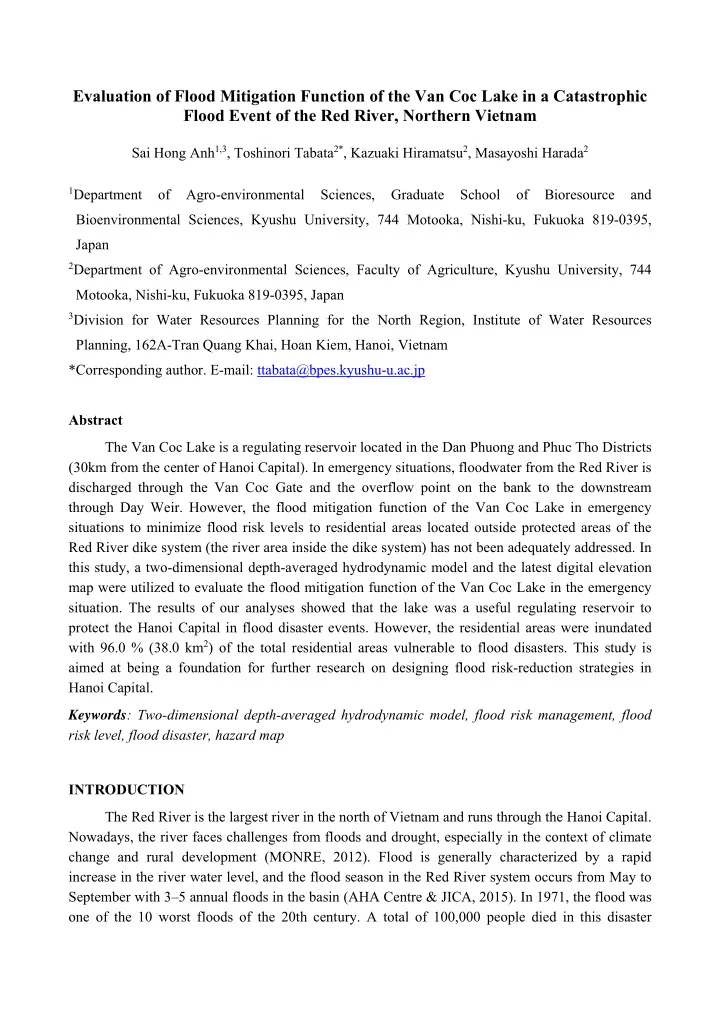
(NOAA, 1993). Until now, protecting the Hanoi Capital from floodwater from the Red River in emergency situations has been an important mission of Vietnam, and many solutions have been provided by the government and its stakeholders (Vietnamese Government, 2011). Presently, as shown in Figure 1, the Hanoi Capital is protected by the Red River dike system, and in emergency situations, floodwater from the Red River is discharged into the Van Coc Lake, which is a regulating reservoir located in the Dan Phuong and Phuc Tho Districts (30 km from the center of the Hanoi Capital), through the Van Coc Gate and the overflow point on the bank of the Red River and is drained to the downstream through the Day Weir. However, the Hanoi Capital has experienced rapid urbanization during the last few decades, and there are many residential areas located outside the protected area of the dike system along the river (the river area inside the dike system) in the Hanoi Capital. The residential areas are highly vulnerable during flood disasters.Moreover, moving thousands of households located outside the protected areas to safer areas is impossible in the near future in a developing country like Vietnam. Therefore, flood risk Figure 1 Location of the research area consisting of a part of the Red River area that runs through the Hanoi Capital from the Son Tay Station to the Hung Yen Station.
SLIDE 3 management needs to be necessary in greater detail than ever. In flood risk management, flood risk mapping and modeling are important for preventing flood damage, and determination of flood- prone areas is a fundamental step (Darabi et al., 2019). Clearly, to evaluate the flood mitigation function of the Van Coc Lake in the operating procedure of the emergency solution based on a comprehensive evaluation of the flood risk level from the Red River to the residential areas is an essential part in the overall development planning of Hanoi. The aim of this study is to evaluate the flood mitigation function of the Van Coc Lake to minimize the flood risk level to the residential areas. A comprehensive assessment results of the impact of floods on residential areas located outside the protected area of the Red River dike system is highlighted as important information for developmental planning of Hanoi. By the latest digital elevation map (DEM) with high spatial resolution, a two-dimensional (2D) depth-averaged hydrodynamic model was constructed to assess flood-related risks in setup scenarios to determine the optimal one. The model was examined by using the observed data from the Red River. We assumed a uniform flow for the downstream boundary conditions in experiments.
MATERIAL AND METHODS
Study area and scenarios Figure 1 depicts the location of the research area comprising a part of the Red River area that runs through the Hanoi Capital from the Son Tay Station to Hung Yen Station, and the Van Coc Lake area. The Red River area was outside the protected areas of the Red River dike system, approximately 110 km in length from the Son Tay Station to Hung Yen Station. Eleven scenarios listed in Table 1 were set to evaluate the flood mitigation function of the Van Coc Lake. In Case 0, the Van Coc Lake was not utilized as a regulating reservoir. In Case 1,
- nly the Van Coc Gate and the Day Weir were operated. In Case 2, the Van Coc Gate, Day Weir,
and overflow point with various opening widths and 13.0 m of the bottom level were operated Table 1: All scenarios for operating procedure of the Van Coc Gate, Day Weir, and various
- pening widths of the overflow point.
Scenario Van Coc Gate Day Weir Overflow point Width (m) Case 0 1st close close close Case 1 2nd
close Case 2 3rd
450 m 4th
650 m 5th
850 m 6th
1000 m 7th
1200 m 8th
1400 m 9th
1800 m 10th
2200 m 11th
2600 m
SLIDE 4 together (Vietnamese Government, 2016). The dike crest elevation at the overflow point is 15.0 m; therefore, the height of the opening section was 2.0 m. Hydrodynamic model A 2D depth-averaged hydrodynamic model was built herein to simulate the floodwater behavior in the area. The shallow water equations used in this study are as follows: Continuity equation:
0
h V y h U x t
(1) Momentum equation in the x and y directions:
3
4 2 2 2 2 2 2 2
h V U U gn y U x U v x g fV y U V x U U t U
h
(2)
3
4 2 2 2 2 2 2 2
h V U V gn y V x V v y g fU y V V x V U t V
h
(3) where U and V are the depth-averaged horizontal velocity components (m/s) in the x- and y- directions, respectively; ƞ is the river water level (m); t is time (s); h is the bottom elevation (m); n is the Manning’s coefficient of roughness (s/m1/3) ; and
h
is the coefficient of the eddy viscosity
(m2/s). The coefficient of the eddy viscosity
h
v was calculated using the Smagorinsky model (1963). The wetting-and-drying scheme of Uchiyama (2004) was introduced for the research area, since the accuracy and stability of the numerical simulation model were affected by the treatments for wet- and-dry fronts, especially in areas with complex geometries. Manning’s coefficient of roughness n for each grid element was set to be n = 0.025–0.172 s/m1/3 depending on the vegetation,
- bstructions, and residential areas.
Boundary conditions The observed river water levels collected in 2013 and 2014 in the Red River area by the Institute of Water Resources Planning, Ministry of Agriculture and Rural Development, Vietnam were used in the model validation. Uniform flow assumption (SUN et al., 2008) used in the scenario analyses was considered at the Thuong Cat and Hung Yen Stations. In the scenario analyses, the observed river water level from the 11-day data of the catastrophic flood in 1971 was used for the upstream inflow boundary conditions at the Son Tay
- Station. The uniform flow assumption was used to calculate the outflow boundary conditions at Day
Weir, Thuong Cat and Hung Yen Stations for all scenarios.
RESULTS AND DISCUSSION
Model validation The model was validated at the Long Bien Station from July 29th to August 7th, 2013 and September 18th to September 29th, 2014. The Nash–Sutcliffe model efficiency (NS) was also calculated to assess the accuracy of the model. In 2013 and 2014, the validation results showed that
SLIDE 5 the calculated river water levels at the Long Bien Station were consistent with observed data. The NSs were 0.75 and 0.85 for both validation periods. The validation results demonstrates the accuracy of the developed 2D hydrodynamic model. The water depth in front of the Day Weir Table 2 presents the maximum water depth in front of the Day Weir at the Van Coc Lake side for all simulated scenarios. The water depth in front of the Day Weir changed depended on the inflow rates at the Van Coc Gate and the overflow point. In the 2nd scenario, the water depth had the smallest value with 4.16 m at the peak, which was lower than the maximum weir height of 4.9 m. Although the water depth increased in the 3rd, 4th, 5th, and 6th scenarios, those were still lower than 4.9 m. In contrast, the water depths in the 7th, 8th, 9th, 10th and 11th scenarios were higher than 4.9 m, with 4.92, 4.95, 4.97, and 4.98 m, respectively. Clearly, when the width of the overflow point was greater than 1200, the water depth in front of the Day Weir was higher than the maximum weir height of 4.9 m. Moreover, the Day Weir was built 70 years ago and has deteriorated, and overload must be avoided. Therefore, the maximum water depth in the 2nd, 3rd, 4th, 5th, and 6th scenarios was much more reasonable. Inundated residential areas Table 3 shows the simulated results of the inundated residential areas when floods reached their peak at the Long Bien Station. In Table 2, the integrated values of the inundated residential areas in the simulated area except for the Van Coc Lake and their percentages compared to the total residential areas in all simulated scenarios are summarized with five inundation depth levels. Most
- f the residential areas located outside the protected area of the Red River dike system were
Table 2 The maximum water depth in front of the Day Weir at the Van Coc Lake side for all simulated scenarios.
SLIDE 6
inundated, with more than 96.0 % (38.0 km2) in all simulated scenarios. The most dangerously inundated residential areas were at Inundation Depth Level 5 from 3.0 m and above for all scenarios. However, there was a decrease in the percentage of the inundated residential areas from 46.4 % (18.4 km2) in the 1st scenario to 39.7 % (15.7 km2) in the 2nd scenario at Inundation Depth Level 5 before dropping to 37.9 % (15.0 km2), 36.2 % (13.3 km2), and 35.7 % (14.1 km2) in the 3rd, 4th, and 5th scenarios, respectively. Moreover, at Inundation Depth Level 5, the inundated residential areas decreased slightly in the remaining scenarios to 34.7 % (13.8 km2) in the 11th scenario. This indicates that the most dangerous flood risk level for the residential areas decreased significantly when the Van Coc Gate, Day Weir, and overflow point were operated. In addition, the simulated results indicate that when the river water level touched its peak at the Long Bien Station, the residential areas were mainly inundated with a depth of more than 1.0 m in all scenarios. This led to huge damage to the residential areas that are highly vulnerable to the impact of floods from the river. Further, there was a slight upward trend in the percentage of the inundated residential areas at Table 3: Inundated residential areas when the flood reached its peak at the Long Bien Station.
Scenario Unit Total inundated residential area Inundation Depth Level
Level 1: 0.2–0.5 m Level 2: 0.5–1.0 m Level 3: 1.0–2.0 m Level 4: 2.0–3.0 m Level 5: 3.0 m and greater
1st % 96.7 1.4 3.2 18.6 27.1 46.4 km2 38.3 0.6 1.3 7.4 10.7 18.4 2nd % 96.3 1.6 5.3 19.9 29.7 39.7 km2 38.1 0.6 2.1 7.9 11.8 15.7 3rd % 96.3 1.7 6.0 20.4 30.3 37.9 km2 38.1 0.7 2.4 8.1 12.0 15.0 4th % 96.1 1.8 6.4 20.6 31.1 36.2 km2 38.0 0.7 2.5 8.2 12.3 14.3 5th % 96.0 1.9 6.3 20.7 31.4 35.7 km2 38.0 0.8 2.5 8.2 12.4 14.1 6th % 96.0 1.9 6.4 20.8 31.6 35.3 km2 38.0 0.8 2.5 8.2 12.5 14.0 7th % 96.1 1.8 6.7 20.7 31.6 35.3 km2 38.0 0.7 2.7 8.2 12.5 14.0 8th % 96.0 1.9 6.7 20.7 31.8 35.0 km2 38.0 0.8 2.7 8.2 12.6 13.9 9th % 96.1 1.9 6.8 20.8 32.0 34.7 km2 38.0 0.7 2.7 8.2 12.7 13.8 10th % 96.1 1.9 6.8 20.8 32.0 34.7 km2 38.0 0.7 2.7 8.2 12.7 13.8 11th % 96.1 1.9 6.8 20.8 32.0 34.7 km2 38.0 0.7 2.7 8.2 12.7 13.8
Inundation Depth Levels 1 and 2 from 1.4% (0.6km2) in the 1st scenario to 1.9% (0.7km2) in the 8th scenario and from 3.2% (1.3km2) to 6.7% (2.7km2), respectively. These results could be explained by the decrease in the percentage at Inundation Depth Level 5 leading to the increase in the
SLIDE 7 remaining Inundation Depth Levels 1, 2, 3, and 4, while the total percentage was almost equal, explained by the decrease in the percentage at Inundation Depth Level 5 leading to the increase in the remaining Inundation Depth Levels 1, 2, 3, and 4, while the total percentage was almost equal, with approximately 96 % for all scenarios. River water level at Long Bien Station Table 4 indicates more clearly the difference in river water level reduction at the Long Bien Station when comparing the 2nd to the 11th operating scenarios with the 1st non-operating scenario. In the 2nd scenario, the river water level at the Long Bien Station decreased significantly to 0.18 m. When the overflow point was opened with 450 m in the 3rd scenario, the river water level decreased to 0.25 m. The difference in river water level was still high at 0.27 m and 0.29 m in the 4th and 5th
- scenarios. From the 6th to 11th scenarios, the difference increased slightly from 0.30 m to 0.31 m
and did not drop further. Obviously, the operation of the Van Coc Gate and Day Weir in the 2nd scenario resulted in a sharp drop in the river water level at the Long Bien Station. Especially, when the overflow point was opened together with the Van Coc Gate and Day Weir, the reduction in river water level increased much more from 0.25 m to 0.31 m. However, owing to the maximum discharge capacity of the Day Weir, the river water level in the last six scenarios went down slightly with approximately 0.31 m of the reduction.
CONCLUSION
This study evaluated the flood mitigation function of the Van Coc Lake to minimize the flood risk level to the residential areas and assessed inundated residential areas when the flood reached its peak at the Long Bien Station. A 2D depth-averaged hydrodynamic model was constructed and the unknown outflow boundary conditions were treated assuming a uniform flow. A wetting-and-drying scheme was used to identify wet and dry areas at each time step. The model was first validated by Table 4 The difference in river water level at the Long Bien Station when comparing the 2nd to 11th operating scenarios with the 1st non-operating scenario.
SLIDE 8 the observed water levels from the research area and the validation results showed the accuracy of the model. Eleven scenarios were set up considering Van Coc Gate, Day Weir, and overflow point with 13.0 m of bottom elevation and various widths of opening section to evaluate the Van Coc Lake function in emergencies. In scenario analyses, the observed river water level from the 11-day data
- f the catastrophic flood in 1971 was used for the upstream inflow boundary conditions. By the
simulation results of the maximum water depth in front of Day Weir, the inundated residential areas
- utside the protected area of the Red River dike system, and the river water level at Long Bien
Station, the Van Coc Lake is essential to reducing the water level at Long Bien Station in
- emergencies. However, residential areas were inundated with 96.0 % (38.0 km2) of the total
residential areas and vulnerable to flood disasters. This study is resourceful to developmental planning of Hanoi Capital, especially for critical developments in Red River basin with adequate protection.
ACKNOWLEDGMENT
The authors appreciate the funding support of JSPS KAKENHI Grant Number JP18H03968 and JP17K15347.
REFERENCES
AHA Centre (ASEAN Coordinating Centre for Humanitarian Assistance on Disaster Management) and JICA (Japan International Cooperation Agency) (2015) Natural Disaster Risk Assessment and Area Business Continuity Plan Formulation for Industrial Agglomerated Areas in the ASEAN Region- Country Report - Vietnam. Darabi, H., Choubin, B., Rahmati, O., Torabi Haghighi, A., Pradhan, B., & Kløve, B. (2019). Urban flood risk mapping using the GARP and QUEST models: A comparative study of machine learning techniques. Journal of Hydrology. Elsevier, 569(November 2018), pp. 142–154. doi: 10.1016/j.jhydrol.2018.12.002. Ministry of Natural Resources and Environment (MONRE) (2012) Climate Change, Sea level rise scenarios for
- Vietnam. Hanoi: Vietnam Publishing House of Natural Resources, Environment and Cartography. (In
Vietnamese) NOAA National Weather Service Public (1993) ‘NOAA’s Top Global Weather, Water and Climate Events of the 20’, US National Oceanic and Atmospheric Administration. Smagorinsky, J., General Circulation Experiments With The Primitive Equations. Monthly Weather Review., 1963,
Sun, D. Po., Xue, H., Wang, P. Tao., Lu, R. Li., & Liao, X. Long. (2008). 2-D Numerical Simulation of Flooding Effects Caused by South-to-North Water Transfer Project. Journal of Hydrodynamics. Publishing House for Journal of Hydrodynamics, 20(5), pp. 662–667. doi: 10.1016/S1001-6058(08)60110-9. Uchiyama, Y. (2004). Modeling wetting and drying scheme based on an extended logarithmic law for a three- dimensional sigma-coordinate coastal ocean model. Report of the Port and Airport Research Institute, 43(4), pp. 3–21. Vietnamese Government (2016a) 257/QĐ-TTg Planning for flood prevention and Red-ThaiBinh River dike system.
- Vietnam. Available at: (In Vietnamese)
Vietnamese Government (2011) 04/2011/ND-CP Abolish the use of flooding diversion areas and flooding diversion system of Day river Vietnam. (In Vietnamese)