Cottenham Village Design Group planning presentation John Williams - - PDF document

cottenham village design group planning presentation john
SMART_READER_LITE
LIVE PREVIEW

Cottenham Village Design Group planning presentation John Williams - - PDF document

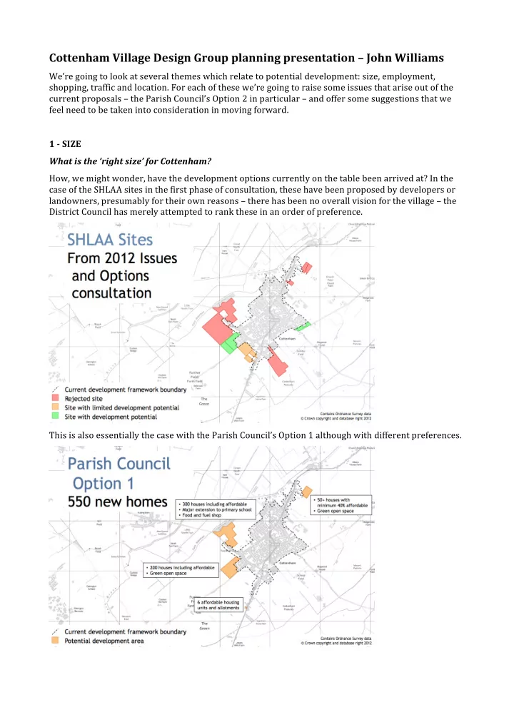
Cottenham Village Design Group planning presentation John Williams Were going to look at several themes which relate to potential development: size, employment, shopping, traffic and location. For each of these were going to raise some


slide-1
SLIDE 1

Cottenham Village Design Group planning presentation – John Williams

We’re going to look at several themes which relate to potential development: size, employment, shopping, traffic and location. For each of these we’re going to raise some issues that arise out of the current proposals – the Parish Council’s Option 2 in particular – and offer some suggestions that we feel need to be taken into consideration in moving forward. 1 ­ SIZE What is the ‘right size’ for Cottenham? How, we might wonder, have the development options currently on the table been arrived at? In the case of the SHLAA sites in the first phase of consultation, these have been proposed by developers or landowners, presumably for their own reasons – there has been no overall vision for the village – the District Council has merely attempted to rank these in an order of preference. This is also essentially the case with the Parish Council’s Option 1 although with different preferences.

slide-2
SLIDE 2

In developing their Option 2 proposals the Parish Council have attempted to address this lack of

  • vision. Their approach seems to have been, in essence, to draw up a ‘shopping list’ of things that might

benefit the village and then work out how many houses might be needed to pay for it. We feel that this ‘shopping list’ approach sees only part of the picture and more weight needs to be given to the effects of any change in size on the quality of life for existing residents, and to assess the potential negative impacts to living a larger settlement as well as the benefits. The potential benefits – more facilities, more employment, improved traffic – are fairly easy to understand. The potential negative impacts are harder to assess. Some – such as greater distances to travel to access facilities or to get to open countryside – can be quantified to some extent, but others – a change in the ‘feel’ of the community from a rural settlement to a more urban one, and a reduction in the distinctive character of the village – are much harder to analyse, and perhaps for that reason easier to ignore. On a more technical point, we’d also like to note that, while Option 2 is specified as being for 1,500+ houses, the shaded areas on the accompanying map – which total around 200 hectares, or a little larger than the existing village – could hold quite significantly more. Even if only half of this area were used for housing and developed at a relatively low density of 25 houses her hectare, this could accommodate 2,500 houses; if 2/3 of the area were developed at 40 houses per hectare (by no means high density) then it might hold over 5,000 houses. Option 3 is stated as being for 4,500 houses, but, depending on how it were developed, the area shown could hold perhaps as many as 7,000.

slide-3
SLIDE 3

So, what suggestions do we have? Perhaps before we make any decisions about planning we should try to determine whether there is an ‘optimal’ size for the village. We do consider that, while now a substantial settlement, Cottenham still manages to maintain significant ‘village’ characteristics, community spirit and pride of place. There are doubtless many reasons for this, but we consider that two significant factors are:

  • First that a high proportion of residents live within fairly easy walking distance of the shops, schools

and community facilities, and of each other, and

  • Second that a very high proportion of children in the village attend the same primary school – which

many of you will know from experience is a major force for forging a close community and integrating newcomers. We think it is likely that a significant proportion of people who live in Cottenham broadly speaking appreciate the type of community it is, and that, while more housing and more facilities within the village are desirable, perhaps even to some extent necessary, any development which involves changing the community beyond recognition is not something that should be undertaken lightly. We consider that distributing houses in smaller developments which are physically close to the existing village core is the best approach to maintaining a close, strong and integrated community. We will expand on this a little later on. We also consider that maintaining a community which can be served by one primary school is desirable, and that adding additional primary schools has the potential to reduce the cohesion of the village and hinder the integration of new residents. Although already large, there is potential to increase the size of the existing primary school, particularly if the infant and junior portions were made more physically distinct. We think that an enlarged school could cope with the level of development envisaged in Option 1, perhaps even a little more. Provision of affordable housing is important. A current need for 140 homes has been assessed. It should be possible to secure this with significantly fewer than 1,500 houses. The 550 houses proposed in Option 1 would require a ratio of 25% affordable homes to achieve this. However, 140 affordable houses should be regarded as a minimum and it would be sensible to plan for more than this over the full planning cycle. For example 700 houses at the same ratio would give 175 affordable units. 2 ­ EMPLOYMENT Could these plans create significantly higher levels of local employment? We don’t know exactly how many jobs there are within the village at the moment – we’ve tried to estimate this and come up with a figure of something like 800, or roughly one for every 3 houses. Obviously by no means all the people doing these jobs live in the village. A 2003 survey found that 24% of respondents worked in the village – this could suggest that the figure may be higher than 800, but it probably includes a quite a high proportion of self‐employed people working from home. On the basis of 800 existing jobs, if we were going to build 1,500 new houses, then simply in order to maintain the current ratio of jobs to houses would mean creating something like 500 new jobs. To make an impact that actually improves the local employment situation to a significant degree would need many more – to double the ratio overall would need around 1,800 genuinely new jobs. We’d see this as a minimum figure to aim for to make Option 2 worth considering. Could a new development attract this many jobs? Even with a bypass, Cottenham would remain relatively poorly connected to the outside world. It is not on the guided busway or a railway, and to reach the trunk road system means negotiating small country roads or bottlenecks in other villages. The next decade or two are liable to see additional commercial development very nearby at

slide-4
SLIDE 4

Northstowe, and probably also at Waterbeach and Cambridge Research Park. All of these sites have better transport links than Cottenham and may be more attractive to employers. Another possible cause for concern is over the density of employment that might be achieved. The area allocated for commercial use in Option 2 could certainly accommodate 1,800 or more jobs in a mix of light industrial, retail and office use, but some uses – in particular warehousing – give a very much lower density of employment which would make the target harder to reach. The density of employment may be something over which we have little control. We also note that many of the older houses in the village – often large and with outbuildings – may be more suitable for some self‐employment activity than today’s average developer house. So a new development might not be able to support levels of self‐employment as high as the existing village. Given these considerations – and even if we assume that the economic situation improves – it seems by no means certain that it will be possible to attract jobs into the village in really large numbers. We think there is a clear risk that a large development might make only marginal improvements to local employment opportunities, and perhaps even some risk that we might end up with more people but fewer jobs per person. In other words it could make matters worse. What suggestions do we have? While we support the Parish Council’s aim of increasing local employment, we are sceptical of any plan which stands or falls on creating very large numbers of local jobs. We do however feel that there is an important place for additional commercial development, in particular small to mid scale commercial

  • units. We were particularly interested by ideas mooted by the Parish Council for start‐up units –

perhaps linked to education and training in some way – which might encourage enterprise generated within the village. That said, we feel that it is a simple fact of life in the 21st century that most people will work some distance from where they live, and while changes to communications and transport mean that home working will probably increase, some degree of commuting will continue to be the experience for most people in the coming generation. We are fortunate that the area we live in provides a relatively wide range of jobs relatively nearby – a very much wider range than could ever be provided within our community alone. One of the best ways we can improve employment opportunities for our residents is to improve transport links to access these jobs. Where possible we would like to see that done

  • sustainably. Initiatives might include:
  • Faster and more direct bus services to Cambridge and the Guided Busway
  • Better cycle links to Northstowe, when it happens,
  • Cycle link to Cambrige Research Park – the back is only a few hundred metres from Long Drove –
  • From there link to any new development in Waterbeach.

3 ­ SHOPPING Would these plans improve the range and accessibility of shops and services? We recognise that, while the current village centre has some very good shops and it is possible to

  • btain most day‐to‐day items in the village, larger retail spaces elsewhere are able to offer more choice

and often lower prices. A new village centre may offer the opportunity to bring such a somewhat larger retail space to the village and have some of these benefits available locally. However, it is hard to see how there could be room both for all the existing businesses in the historic centre and those in a new centre. There is a strong possibility that, owing to competition and a reduction in passing trade, several of the retail outlets in the current centre would close. One big advantage of the current centre is that it is actually very convenient for most people in the village – something approaching 90% of people are within an 10 minute average speed walk (800m)

  • f the Co‐op. This is shown by the blue line in the left‐hand diagram.
slide-5
SLIDE 5

For the new village centre, this figure is unlikely to be more than about 30% for existing residents. The purple line in the right hand diagram tries to give an idea of this. You’ll see that residents in the south

  • f the village would be really quite a long way away from the new centre. Older residents in Franklin

Gardens, who are currently little more than a hundred metres from their nearest shop, could face a journey of something like a kilometre to the new village centre. So, while a new village centre might offer more choice, it would also be significantly less accessible for many existing residents. It is possible that it might even lead to an increase in the proportion of shopping trips made by car, even if the length of some of those trips were reduced. So, what suggestions do we have? It would somewhat ironic if a by‐pass were to ease traffic problems in the middle of the village, and perhaps create conditions which might be more attractive to shoppers, but the shops in this area were killed off by other factors. We feel that there is a strong argument for maintaining and strengthening what we have – the existing village centre. We believe that we should investigate a series of smaller‐ scale initiatives which, while they may not offer everything we could desire, could improve matters incrementally – these might include: Additional and more accessible parking – the Co‐op car park is poorly laid out, hard to find and hard to

  • access. We need to recognise that some shoppers want to drive and to provide more easy to find, safe,

legal and accessible parking for passing trade.

  • Several more pedestrian crossings in the central area of the village – ideally these should be raised

and/or traffic light controlled.

  • A 20mph limit in the centre of the village should also be considered.
  • These last measures should act not only to make things more convenient and safer for pedestrians,

but also to make the village less attractive as a short cut for through traffic.

  • We could also look for opportunities for retail and office and development on central sites, including

the re‐use of redundant or under‐used old agricultural buildings, offering incentives if possible.

slide-6
SLIDE 6

4 ­ TRAFFIC Would these plans improve the traffic situation? It seems plausible that a by‐pass would improve the traffic situation within Cottenham. We do however have a specific concern over the details of the design shown in Option 2 (see map in section 1 above)– this would mean creating a new settlement with a potentially busy road dividing it in two, which seems a questionable option both for road safety and for community cohesion. We would also like to note that a Cottenham by‐pass would do nothing to address traffic problems in the wider area – it could in fact make bottlenecks at Histon worse by attracting additional through traffic to the B1049, and even result in increased journey times for Cottenham residents commuting to Cambridge. What suggestions do we have? While we see the possibility for major advantages in a by‐pass, we think many residents will feel that the ‘cost’ – absorbing 1,500 or more additional houses – would be too high. We think that the village’s traffic problems need to be viewed in context of traffic flows in the wider

  • area. The most significant cause of our problems is the shamefully inadequate nature of the A10

between Stretham and Cambridge (and to a lesser extent of the A14) and any long‐term solution needs to address this. At its closest point the A10 is only a mile from the B1049 – it should really function as a Cottenham by‐pass, but instead the B1049 and other local roads function as an A10 by‐pass. A potential new settlement at Waterbeach brings the threat of making this problem worse – but also strengthens the argument, and perhaps brings an opportunity, for an improvement which could address the traffic problems of Cottenham as well, and reduce the need for a by‐pass. In the mean time, additional traffic calming and pedestrian friendly measures need to be adopted in the village, both to improve safety and to deter rat‐running. 5 ­ LOCATION Are the proposed developments in the best place? One of the reasons initially given by the Parish Council for suggesting the development of land to the north‐east of the village seems to have been that this area lies outside of the Green Belt. They also

  • pposed three of the SHLAA sites on the grounds that they included Green Belt land. However, we note

that Option 2 as submitted now also includes a by‐pass and other developments on Green Belt land further south, which suggests a shift of views on this matter.

slide-7
SLIDE 7

We also note that much of the north‐eastern development is relatively far from the existing core of the village, and that the potential to create pedestrian links between this area and the existing village may be limited. There are a few small roads and tracks that lead into this area either from Rooks Street or from the northern stretch of the High Street, but most of these are private and we simply don’t know whether it would prove possible to create the kind of links that will ensure the two communities are

  • united. The experience of the Broad Lane development, where only one out of three proposed

pedestrian links to the High Street ever became a reality, suggests potential difficulties. Even if it is possible to create several pedestrian links, the connections between this area and the existing village core are unlikely to be really good. If this area is poorly integrated with the rest of the village, has its own shops, and perhaps its own school, then we think there is a strong possibility that it would take on much of the character of a separate adjoining settlement rather than an integral part of Cottenham. We also note that if major development went ahead to the north east of the village the impact on existing recreational routes would be particularly severe – Church Lane and Long Drove are both heavily used by walkers, runners, dog walkers, cyclists and riders, and currently offer good long views into the countryside. Footpath and open space provision in the parish is already inadequate. What suggestions do we have? On simple geographic grounds we are doubtful whether the area to the north east of the village is suitable for large‐scale residential development. Some parts immediately adjacent to the existing village may be suitable for smaller‐scale housing, while other parts could have some potential for commercial development. We feel that residential development should concentrate on areas that have the potential to integrate well with the existing village. This next map attempts to show a first step towards determining where these areas might be. It shows circles of 500m radius drawn around existing village facilities – the Co‐

  • p, Primary School, Village College and the cluster of businesses around the village sign.

The existing village framework is shown in red, the green belt in bright green. It is noticeable that the area which seems to show the greatest potential for connectivity is that to the south east of the Village College and of Brenda Gautry Way, while the area to immediately south of that, the area to the north west of the primary school, and a smaller area between Oakington Road and Histon Road also seem to

  • ffer some potential.

We think that this map gives an indication of where we might look for the areas most appropriate for

  • development. We recognise that some of these areas would encroach on the Green Belt. However,

these would be relatively small encroachments. We feel that the current boundaries of the Green Belt, drawn up many years ago, are now acting to push development into much less appropriate areas and

slide-8
SLIDE 8

hindering the development of some of our community facilities, and that a review of Green Belt boundaries is justified at this time. We think that the area to the south east of the village offers significant potential to enhance the Village College, which is currently hemmed in on its site by Green Belt. There is also the potential to enhance the Sports Centre, which is also on a very restricted site with very poor access. Inappropriate parking in the important green space in front of the College could also be reduced. Development in this area would require new access routes, and it might prove possible to join these up to provide a link between Histon Road and Beach Road – this could significantly reduce any additional through traffic generated by new housing in this area, since it would not need to pass through the village to reach Cambridge or the A10, and perhaps also make a small contribution to the reduction of other traffic. Whatever size or location of development goes forward it will also be vital to include significant improvements both to public open space and to access to the open countryside in the form of additional footpath and cycle path links. Some of this could be achieved by incorporating paths within strips of planting which also shelter the edge of new developments. These need to be designed in from an early stage and planned in a coherent way so that routes link up with each other and with existing routes, which has not been the case in some recent initiatives. CONCLUSION So, to conclude, while we agree with many of the objectives of the Parish Council, we have significant concerns about their proposals as they currently stand. There needs to be more research to underpin whatever decisions are made, and a wider range of factors need to be considered. We would like to put forward the following considerations as principles that could help to inform any new development. Cottenham should be:

  • a village where a high proportion of people can easily walk to shops and schools
  • a village that remains as a single, strong community, served by one primary school
  • a village which builds on and improves the facilities it already has
  • a village with local employment opportunities, but also with good access to wider and more

varied opportunities nearby

  • a village with good access to the countryside
  • a village which retains its own distinctive character