Clontarf has flooded before Protection Project In February 2002 a - - PDF document

clontarf has flooded before
SMART_READER_LITE
LIVE PREVIEW

Clontarf has flooded before Protection Project In February 2002 a - - PDF document

11/7/2011 Clontarf Flood Protection Project Clontarf Flood Protection Project is all about protecting people Their lives Their homes Th i h Their livelihoods Tom Leahy Executive Manager (Engineering) 2003 2005 Coastal Flood


slide-1
SLIDE 1

11/7/2011 1

Tom Leahy Executive Manager (Engineering)

Clontarf Flood Protection Project

Clontarf Flood Protection Project is all about protecting people Their lives Th i h Their homes Their livelihoods

Clontarf has flooded before

In February 2002 a 1/60 year event devastated the area. At risk of a repeat of this event every year D i thi t t t l f Cl t f i t Doing nothing to protect people of Clontarf is not an option

2003 – 2005 Coastal Flood Protection Project

Flood Maps of area at risk Tidal surge early warning system

2003‐2005 Outline Design

Range of potential solutions examined to protect people of Clontarf Recommended option is NOT a 9 Ft wall for 3 Km Km. Recommended option is a landscaped mounding and some limited walls where not possible (e.g. at car parks).

Wall locations( Mounding not possible with car parks)

Hollybrook rd car park Clontarf Baths Vernon Av Car Park Yacht Club & Dublin Bus Car park

slide-2
SLIDE 2

11/7/2011 2

Photomontages (sample) of Approved Scheme compared to Bord Pleanala Scheme

Based on indicative output from Design Review. F ll D i R i t b fi d i N b Full Design Review to be confirmed in November and requires assessment by OPW and Dublin City Council that it will provide required level of protection.

Photomontage Locations

1. Seaview Av 2. Sports ground 3. Oulton Rd 4. Kincora Rd

Photomontage Locations

View 4 View 3 View 1 View 2

Seaview Av

Existing View

Coastal Flooding Clontarf 2002

Historical Flooding on Clontarf Road

slide-3
SLIDE 3

11/7/2011 3

Seaview Av View following construction of current design (ABP approved). Approx 2.1m high View following construction of Design review heights (1.41m) 0.69m reduction in height Seaview Av

Existing View

Sports ground

Existing View

Sports ground View following construction of current design (ABP approved). Approx 2.6m high View following construction of Design review heights (1.43m) 1.17m reduction in height

slide-4
SLIDE 4

11/7/2011 4

Sports ground

Existing View

Oulton Rd

Existing View

Oulton Rd View following construction of current design (ABP approved). Approx 2.6 m high View following construction of Design review heights (2.15m) 0.45m reduction in height (Area lower and most at risk) Oulton Rd

Existing View

slide-5
SLIDE 5

11/7/2011 5

Kincora Rd

Existing View

Kincora Rd View following construction of current design (ABP approved). Approx 1.15m high View following construction of Design review heights (1.04m) 0.11m reduction in height Kincora Rd

Existing View

Animation Locations

1. From Stranville moving East 2. From Clontarf baths moving East 3. From the Bull wall ( wooden Bridge ) moving west

Animation Locations

Animation 3 Animation 1 Animation 2

slide-6
SLIDE 6

11/7/2011 6

2005 – 2007 Detailed Design

Everyone agrees flood defences in Coastal areas are essential Design carried out by International Consultants expert in complexity of coastal design and p p y g considered best technical information. Design:

Predicted sea level 1/200 year storm event Predicted sea level rise over 50 years Impact of wave action in 1/200 year storm

No point in investing in defences which do not protect people!

2007 – 2009 Statutory Process

EIS to An Bord Pleanala Non Technical Summary Public Display Meetings Notified to Residents and Business Associations Approved by An Bord Pleanala after detailed consideration

2009 – 2010 Funding Approval

OPW 2011 budget DECLG Water Services Investment Programme 2010 to 2012

2010 ‐ 2011

Tendering and Procurement of Contractor Plan to construct in 2012-2014 People fully protected by 2014 after a 7 year long (2003 2011) process (2003 – 2011).

2011 Design Review due to concern about height

  • f mounding and enjoyment of promenade

Confirmed Clontarf at high risk of flooding

Highest Astronomical tide = 1.99 m. OD 1/200 Storm event still water level = 3.13 m Climate change sea rise to 2055 = 3.34 m. OD Wave height varies 0.5 m. to 0.9 m. due to coast

exposure. It is possible to reduce height while providing protection to people of Clontarf.

Summary of Design Review

Reduced levels will improve views and amenity Anything lower will not protect people of Clontarf from Flooding.

slide-7
SLIDE 7

11/7/2011 7

Adaptive Management Approach

An adaptive management approach should be adopted now, whereby the new defence structures are built with their foundations and layout designed to allow them to be raised in due course, if necessary. Ongoing monitoring and maintenance will deal with risks such as settlement of or damage to embankments The versatility to allow the defences to be raised in the future, for whatever reason, would ensure that the scheme will provide a 1 in 200 year standard for at least the next 50 years.

2007‐2009 Statutory Planning Process (submission of EIS to ABP and granting of planning permission) 2009‐2010 Funding Approval (WSIP 2001‐2012 and Cost benefit analysis for OPW) 2010‐2011 Tendering and Procurement of Contractor

2012‐2014 Construction And Protection of Business and Residents

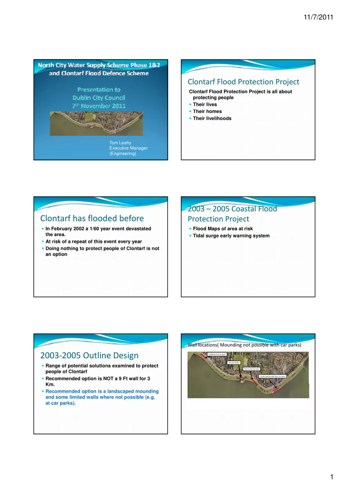
Building Blocks of Clontarf Flood Defence 2002 Tidal Flooding event event 2003‐2005 Dublin Coastal Flood Protection Project (Outline Design) 2005‐2007 Detailed Design Process

g g p g p

Views when walking along roadway Uninterrupted view Obstructed view area subject to severe flooding post 2002 Partially interrupted view

100m 400m

West of Bath 1200m Baths to Vernon Av 700m East of Vernon Av 1100m Location May 2006 Height EIS Design 2007 Height Design Review 2011 Height Max Min Av Max Min Av Max Min Av W f B h 8 8 8 West of Baths (1200m) 1.44 0.3 1.03 2.58 0.85 1.75 1.59 0.45 1.18 Baths to Vernon Av (700m) 1.82 0.82 1.41 2.75 1.32 2.09 2.17 1.02 1.71 East of Vernon Av (1100m) 1.15 0.51 .76 1.8 1.01 1.44 1.5 0.71 1.11 Lower Level of mounds recommended in Design Review (November 2011) compared to An Bord Pleanala Approved Scheme

Next Steps

Public Briefing and opportunity to make views known Report on Planning and Funding issues to December City Council meeting December City Council meeting Clontarf Flood Protection Project is all about protecting people Their lives Their homes Their livelihoods