SLIDE 1
Basic Hydrologic Processes
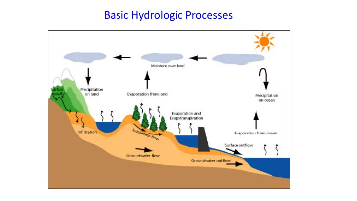
SLIDE 2
Basic Output: Water balance
Basic Approach: Look at the Hydrologic Budget P + Qi - Qo - R(I) – E – T = ∆S P = Precipitation Qi = Inflow Qo = Outflow R(I) = Recharge E = Evaporation T = Transpiration ∆S = Change in Storage I = Infiltration is a process : I = T+R+Q0 Qo
Control Volume
SLIDE 3
Watersheds
NOAA Definition: “It is a land area that channels Rainfall and Snowmelt to creeks, and rivers, and eventually to Outflow Points such as reservoirs, bays, and the ocean”
Typically WSBs align along ridges. Watershed 1 Watershed 2
SLIDE 4
Watershed Components
SLIDE 5
How do we combine these data?
Digital Elevation Models Watersheds Streams Waterbodies
Watershed Data Layers
SLIDE 6
An integrated raster-vector database
Watershed Data Layers
SLIDE 7 2-digit water resource regions 8-digit HUC watersheds
Region 01 New England Region 02 Mid-Atlantic Region 03 South Atlantic-Gulf Region 04 Great Lakes Region 05 Ohio Region 06 Tennessee Region 07 Upper Mississippi Region 08 Lower Mississippi Region 09 Souris-Red-Rainy Region 10 Missouri Region 11 Arkansas-White-Red Region 12 Texas-Gulf Region 13 Rio Grande Region 14 Upper Colorado Region 15 Lower Colorado Region 16 Great Basin Region 17 Pacific Northwest Region 18 California Region 19 Alaska (Old numbering system) Region 20 Hawaii Region 21 Caribbea
Watersheds of the US
SLIDE 8 8 HUC 4 2 6 NHDPlus 10 12 Available In Progress Digit #
Sub-Region Region Accounting U Catalouging U WaterShed Sub-WaterShed
Watershed Hierarchy
02 Mid-Atlantic Region 0201 Richelieu 020100 Richelieu, NY & VT 02010001Lake George 02010004Ausable Example 02010004Great Chazy-Saranac
SLIDE 9
~ 2000 for US, about the size of counties
Hydrologic Unit Code (8-Digit) Watersheds
SLIDE 10
2990 HUC12 watersheds of average area 39.3 square miles HUC12:HUC8 ~ 40:1 watersheds
Watershed Boundary Data for Nebraska
SLIDE 11
EPA Reach Files 100 grid cell threshold 1000 grid cell threshold
Watershed Stream Network
SLIDE 12
EPA River Reach File 1
SLIDE 13
Lower West Fork, Trinity River Basin HUC = 12030102
SLIDE 14
USGS Mission Area: Water Resources
SLIDE 15
Precipitation
Standard way of measuring rain- or snowfall is a standard rain gauge. Rain Gauge or “Bucket” Tipping Mechanism For inaccessible areas => Satellite Imagery.
SLIDE 16
Precipitation
SLIDE 17 Hourly Data for US Stations starting 1951 https://data.nodc.noaa.gov/cgi-bin/iso?id=gov.noaa.ncdc:C00313
Precipitation Data
… many more!
- Gridded (various res)
- Monthly mean
- Yearly mean
- forecasts