SLIDE 1 A special approach of urban inequalities: the French metropolitan area example
Quentin Godoye, Frédéric Audard, Sébastien Oliveau, Contact : quentin.godoye@etu.univ-amu.fr Aix-Marseille University The study of social groups distribution in the city is a vast, yet well-defined, field in social sciences. The development of Chicago’s School of Sociology marks the beginnings of this field. Numerous qualitative surveys have been conducted by E. Burgess and E. Park and their team using the life story method to study the evolution of individuals’ dwelling in Chicago (Bertaux, 1980). Burgess and Park also developed the idea
- f urban ecology, looking at the city not only like an artificial construction, but also like a product of human
nature and the results of the struggle between social groups to claim this territory (Joseph, Grafmayer, 2009; Wacquant, 1992). Analyzing the life stories gathered, Burgess tried to model the individuals’ trajectory inside the city, from their arrival to their integration. From this analysis, he then created the concentric model. Following this work, two other models have been developed: the sectorial model (Hoyt, 1939), describing the socioeconomic distribution of the population, and the polynuclear model (Harris et Ullman, 1945), showing the ethnic distribution. From the 60’s, the emergence of the new geography renewed the interest for this research subject using quantitative methods. These methods enabled us to describe, measure and analyze the population distribution, but also to question the population distribution models developed by sociologists (Madoré, 2016). Our work’s objective is to study the population distribution in contemporary French metropolises going back to the original models, and using contemporary quantitative methods. The aim is to combine multiple quantitative methods together to get closer to the qualitative method used by the Chicago researchers. To achieve this, we mobilized the socioeconomic, sociodemographic and socio-ethnic variables available at finest geographical level. We used the smallest intracity scale data from the 2013 general census lead by the National Institute of Statistics and Economic Studies (i.e. IRIS1). In this poster, we have chosen to
1 IRIS stands for « Ilôts de référence de l’information statistique » and are the finest census districts in France.
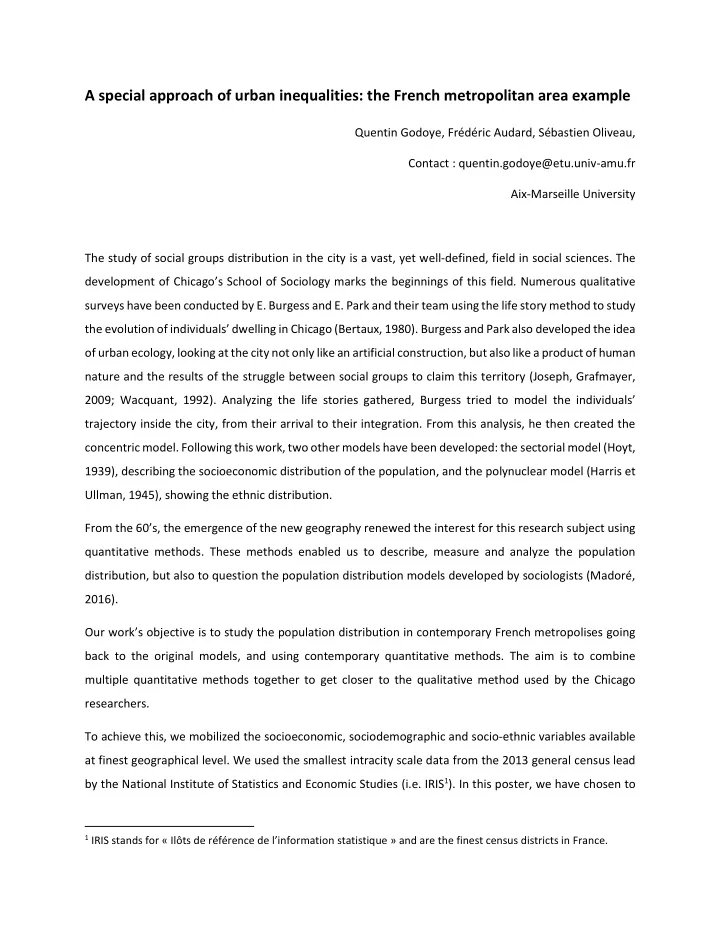
SLIDE 2 focus on the city of Paris to highlight the methodological contribution in our approach of the subject. We will also explore the socioeconomic dimension, and more precisely the “managers and professionals”. Our approach starts with the construction of univariate maps of each of our variables. These maps, which
- nly have a descriptive purpose, allow for a first perception of the population distribution disparities. For
example, we can see on the “managers and professionals” distribution map that this social group is mostly located in the inner city, as well as in the western part of the urban hub. However, using only the univariate “managers and professionals” map, we are not able to go further than the descriptive analysis, and we cannot quantify the observed phenomenon.
Figure 1 : spatial distribution of the “managers and professionals” in Paris (2013)
We carried on with our study using multiple segregation indexes. Massey and Denton (1988) classified those indexes in 5 main dimensions. Here, we will study the dimensions of evenness, concentration and clustering, using respectively Duncan’s segregation index, the Delta Index and the RCL index. These indexes allow us to measure the intensity of the distribution disparities thanks to cartography. The city suburbs show higher distribution disparities than other spaces, even though those spaces are not as
SLIDE 3 concentrated as the inner city and its close suburb. These indexes give a new dimension to social inequalities in space, but do not deliver information on each unit (they are global indexes). To go further and explore the local situations, we used a hierarchical cluster analysis (HCA) of our units. HCA is a multivariate exploratory analytical method. It allows us to create a socioeconomic and sociodemographic landscape of IRIS clustering them by class using their statistical resemblance. Thanks to the HCA, each territory is described from the populations occupying it. This method lets us establish the main population distribution structures. The socio-professional category classification in Paris shows a quite clear spatial structure. The central territories and those close to them to the West show an
- verrepresentation of “managers and professionals”. The pericentral spaces are characterized by an
- verrepresentation of intermediate professions and craftspeople, whereas the peripheral spaces have an
- verrepresentation of blue-collars and employees. This classification presents first a concentric structure
- f the PCS (Social Professional Categories) distribution in the Parisian agglomeration, even if sectorial
repartition elements can also be found. However, this method analyzes each territory according to the nature of its population using the population profile of the other spatial units. Yet the spatial population concentration and the position of each spatial unit in relation to the others is not accounted for.
SLIDE 4 Figure 2 : Hierarchical cluster analysis of socioprofessional categories in Paris (2013)
The local indicators of spatial association (LISA) developed by Luc Anselin (1995) allow us to explore this particular dimension. We used LISA to identify the population clustering zones, in other words the spaces with values above the average in an environment where other individuals also have higher than average values (hot spots). Using LISA enables us to change the analysis scale. The segregation indexes address the global measure
- f spatial disparities, and the HCA offers a social profiling of individuals without taking into account the
space beyond the class cartography. As for LISA, its approach is univariate, spatial and local. These indicators highlight territories marked by specific population clusterings. We can then draw the spaces occupied by different PCS, and, if there is any, the shared spaces. The third map clearly shows that the “managers and professionals” clusterings are located in the inner city and to the West of the urban hub, whereas the intermediate professions are in the urban hub, and the blue-collars’ are in the outskirts
- f the periurban area. The employee clusterings are mainly specific to the spaces to the North-East of the
SLIDE 5
urban hub. The urban structures visible on the PCS LISA map of Paris are complementary to the ones given by the HCA. We therefore combined the two methods.
Figure 3 : LISA of the PCS in Paris (2013)
SLIDE 6 Combining the two methods does not only mean adding up both results. In this case, we would keep two separate maps for each. The association of the two maps gives a new dimension to our results (see figure 4). Figure 4 lets us identify the multiple dimensions characterizing the population distribution disparities. The HCA, being a multivariate aspatial method, highlights the territories’ profiles taking into account all groups together. To be part of the HCA results, the group of interest must then be present in a high enough proportion in some, but not all, spatial units, to be able to have influence on the nature of the classification
The local indicators of spatial association show first and foremost the population clusterings in the neighboring IRIS. This means that the LISA identify first the “clustering” dimension in the Massey and Denton terminology. The only thing that matters is the proportion of the studied group for each spatial unit, not the proportion of the other population groups in the unit.
Figure 4 : Dimensions of spatial inequalities Following Reardon, O’Sullivan, 2004.
SLIDE 7 Combining the two methods lets us identify multiple population distribution disparities. The only distribution method that these two methods do not evaluate is the uniform distribution (figure 4, upper right corner). The fact that a population group is both grouped and concentrated is a different situation than it being only concentrated or only grouped. This means that the group of interest is in high proportion in both the spatial unit and its neighboring units, and this group shares this space with little to no other
- group. This is then the most unequal population distribution, as it translates into an inequality intra and
inter spatial unit.
Figure 5 : Socioprofessional Classification and LISA in Paris (2013)
This is what it happening in the map, with the superposition of the HCA class 2 and the “managers and professionals” LISA in the inner city of the Parisian agglomeration and in the western part of the urban
- hub. Moreover, another interesting result coming from combining the two methods is the case where the
LISA of a PCS and the HCA class where that same PCS is overrepresented but do not overlap. We can see this case in the outskirts of the periurban suburbs. We can observe there some employees and blue-collars concentrations (results from the HCA), but only the blue-collars are grouped (results from the LISA), not
SLIDE 8
the employees. This means that the employee concentrations are more dispersed in this part of the urban space than the blue-collars’. However, the employees are grouped in the North East part of the urban hub, which is in accordance with the HCA, which is not the case for the blue-collars. Combining the HCA and LISA gives us an information with a higher quality and quantity compared to using each method separately.
Bibliography
ANSELIN L., 1995, « Local Indicators of Spatial Association—LISA », Geographical Analysis, 27, 2, p. 93-115. BERTAUX D., 1980, « L’approche biographique : sa validité méthodologique, ses potentialités », Cahiers Internationaux de Sociologie, 69, p. 197-225. JOSEPH I., GRAFMEYER Y., 2009, L’école de Chicago : Naissance de l’écologie urbaine, Paris, Editions Flammarion, 377 p. MADORÉ F., 2016, « Approche comparative de la ségrégation socio-spatiale dans les aires urbaines françaises », Annales de géographie, 706, p. 653-680. MASSEY D., DENTON N., 1988, « The dimensions of residential segregation », Social Forces, 67, 2, p. 281-315. WACQUANT L., 1992, « Banlieues françaises et ghetto noir américain : de l’amalgame à la comparaison », French Politics ans Society, 10, 4, p. 81-103.