2014-2016 Cdiz, 20 October 2016 Interferometric Sonar An - - PowerPoint PPT Presentation

2014 2016
SMART_READER_LITE
LIVE PREVIEW

2014-2016 Cdiz, 20 October 2016 Interferometric Sonar An - - PowerPoint PPT Presentation

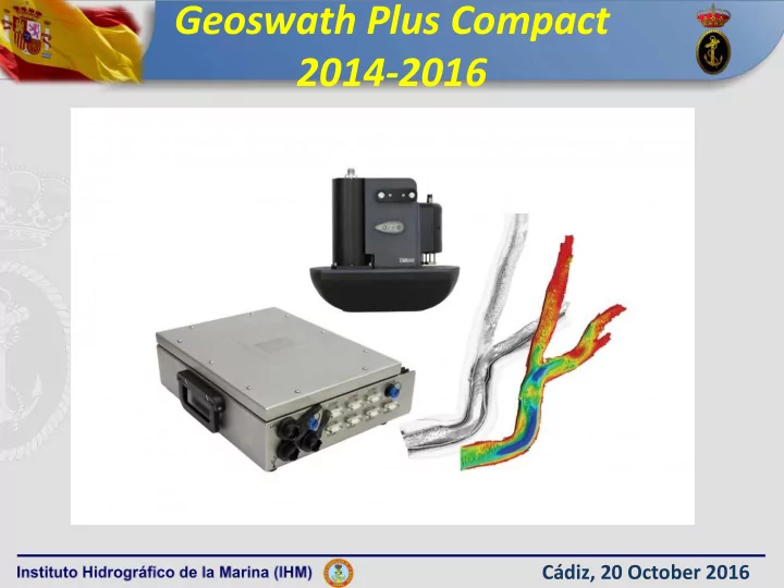
Geoswath Plus Compact 2014-2016 Cdiz, 20 October 2016 Interferometric Sonar An interferometric sonar can be considered a multi-stave side scan , collecting a wide swath of bathymetry up to 12 times depth and sonar amplitude data , with the


slide-1
SLIDE 1

Geoswath Plus Compact 2014-2016

Cádiz, 20 October 2016

slide-2
SLIDE 2

Cádiz, 20 October 2016

Interferometric Sonar

An interferometric sonar can be considered a multi-stave side scan, collecting a wide swath

  • f bathymetry up to 12 times depth and sonar

amplitude data, with the angle of arrival of the seabed returns determined by phase comparison between the receive staves

slide-3
SLIDE 3

Geoswath Plus Compact

The Interferometric Sonar Geoswath Plus, is a very useful tool for shallow waters where the Special Order is required.

Cádiz, 20 October 2016

slide-4
SLIDE 4

Geoswath Plus Compact

IHM: owns three Geoswath Plus Compact (one 250 KHz and two 500 KHz)

Cádiz, 20 October 2016

slide-5
SLIDE 5

Geoswath Plus Compact

  • TWO TRANSDUCERS IN A SINGLE-HEAD SYSTEM.
  • EACH TRANSDUCER: 5 CERAMIC STAVES. 1 TO TX, 4 TO RX.
  • FIELD OF VIEW: 240 º (VERTICAL) AND 0,5º (HORIZONTAL TWO WAY BEAM).
  • EFFECTIVE HORIZONTAL RANGE FOR BATHYMETRY: UP TO 8 TIMES DEPTH

(IHO SPECIAL ORDER) Cádiz, 20 October 2016

slide-6
SLIDE 6

Geoswath Plus Compact

Cádiz, 20 October 2016

slide-7
SLIDE 7

Geoswath Plus Compact

  • DEPLOYED OVER-THE SIDE POOL MOUNTED IN VESSELS OF OPPORTUNITY

Cádiz, 20 October 2016

slide-8
SLIDE 8

Geoswath Plus Set-Up

Cádiz, 20 October 2016

slide-9
SLIDE 9

Geoswath : Advantages

  • HIGH PERFORMANCE: in very shallow waters, in

comparison to a multibeam (for example below 10 meters “8x GS vs 4x Multibeam”).

  • GEO-REFENRENCED SIDE SCAN SONAR for a reliable

bottom classification and object detection.

Cádiz, 20 October 2016

slide-10
SLIDE 10

Geoswath : Disadvantages

  • NOT HIGH DATA COVERAGE WITHIN THE NADIR . High overlap

between lines to meet the IHO specifications for “Special Order” for feature detection.

  • SOPHISTICATED FILTERS REQUIRED during acquisition or during

a pre-processing stage, in addition to be supported during the post processing stage (CARIS processing) by a reliable error model, such as The Combined Uncertainty Bathymetric Estimator (CUBE).

Cádiz, 20 October 2016

slide-11
SLIDE 11

PROCESS WORKFLOW: BEFORE GS4 AND CARIS 9.022

WITH THE PREVIOUS SOFTWARE GS+ AND EARLIER VERSIONS OF CARIS 9.022

  • SLOW WORKFLOW. necessary to pre-process data applying

filters to the raw data with the GS+ software.

  • Remove background noise coming from acoustic and electronic origin
  • Return from WC and surface backscatter
  • FILTERED POINTS during acquisition or during a pre-processing

stage not recoverable in CARIS.

  • If filters were not applied correctly you would have to run the line again

Cádiz, 20 October 2016

slide-12
SLIDE 12

PROCESS WORKFLOW: WITH GS4 AND CARIS 9.022

  • THE NEW SOFTWARE GS4:
  • GS4 replaced the GS+ software in 2015. A completely re-

worked version, providing higher performance and a contemporary graphical interface.

  • Filters can be applied during acquisition
  • LATER VERSIONS OF CARIS 9.022
  • Allow to recover the discarded points filtered with all

processing filters used in GS4 during the acquisition stage.

  • Possible to apply processing filters during the acquisition
  • survey. Raw data can be treated directly in CARIS HIPS

without having to run the GS4 Processing Module.

Cádiz, 20 October 2016

slide-13
SLIDE 13

PROCESS WORKFLOW: WITH GS4 AND CARIS 9.022

SURVEY LINE PLANNING 110% OVERLAP "SPECIAL ORDER"

ACQUISITION: APPLYING GS4 PROCESSING FILTERS REMOVING BACKGROUND NOISE. (DISCARDED POINTS CAN BE RECOVERED) CARIS PROCESING: LINE CONVERSION *.RFF

  • APPLY LINEAR SENSOR

OFFSETS AND CALIBRATION OFFSETS. CARIS PROCESSING:

  • APPLY SVP
  • LOAD TIDES/COMPUTE GPS

TIDE (RTK)

  • MERGE DATA.

CARIS PROCESSING: COMPUTE TOTAL PROPAGATED UNCERTAINTY (TPU) CARIS PROCESSING: CUBE SURFACE ELABORATION CARIS PROCESSING: REMOVING AND DESIGNATION SOUNDINGS

CARIS PROCESSING: FINAL PROCESSED SURFACE

Cádiz, 20 October 2016

slide-14
SLIDE 14

SURVEYED AREAS WITH GS500/250 2014-2016

GUADIANA ESTUARY. GS500 2015 VIGO ESTUARY. GS500 2015 PORT OF MARIN. GS500 2015

Cádiz, 20 October 2016

slide-15
SLIDE 15

SURVEYED AREAS WITH GS500/250 2014-2016

PASAJES ESTUARY AND SAN SEBASTIAN COAST. GS250 2015

Cádiz, 20 October 2016

slide-16
SLIDE 16

SURVEYED AREAS WITH GS500/250 2014-2016

MIÑO RIVER ESTUARY AND LA GUARDIA

  • COAST. GS250 2015 AND 2016

Cádiz, 20 October 2016

slide-17
SLIDE 17

SURVEYED AREAS WITH GS500/250 2014-2016

FERROL PORT. GS250 2016 BALDAIO SHALLOWS. GS500 2016 PORT OF BILBAO. GS500 2016

Cádiz, 20 October 2016

slide-18
SLIDE 18

CONCLUSSIONS

  • HIGH PERFORMANCE FOR VERY SHALLOW WATERS…RIVERS???
  • EASILY TRANSPORTABLE
  • CHEAP
  • DOES NOT WORK PROPERLY WITH ROUGH SEAS
  • PROCESSINGWORKFLOW STILL VERY LOW
  • REQUIRES GOOD SKILLS AND STRONG KNOWLEDGE OF WHAT

YOU´VE GOT IN YOUR HANDS

Cádiz, 20 October 2016