SLIDE 1
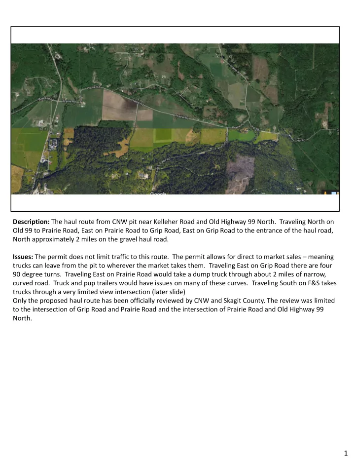
Description: The haul route from CNW pit near Kelleher Road and Old Highway 99 North. Traveling North on Old 99 to Prairie Road, East on Prairie Road to Grip Road, East on Grip Road to the entrance of the haul road, North approximately 2 miles on the gravel haul road. Issues: The permit does not limit traffic to this route. The permit allows for direct to market sales – meaning trucks can leave from the pit to wherever the market takes them. Traveling East on Grip Road there are four 90 degree turns. Traveling East on Prairie Road would take a dump truck through about 2 miles of narrow, curved road. Truck and pup trailers would have issues on many of these curves. Traveling South on F&S takes trucks through a very limited view intersection (later slide) Only the proposed haul route has been officially reviewed by CNW and Skagit County. The review was limited to the intersection of Grip Road and Prairie Road and the intersection of Prairie Road and Old Highway 99 North.
1
SLIDE 2
Description: Grip Road traveling East of the mine entrance. Four 90 degree turns are not navigable for dump truck and pup trailer. Issues: Example of what you find on other protentional haul routes. This is why every potential haul route needs to be identified and studied prior to issuing a permit.
2
SLIDE 3 Description: Grip Road and Prairie Road intersection. Anyone ever see an accident at this intersection? Anyone ever have a near miss at this intersection? Issues: Per DN Traffic Consultants, this intersection is sub-standard. Should have 445’ of site
- distance. DN recommended fixing the sight distance issue but due to cost, recommend “advanced
warning signs with flashing beacons”. DN did not provide any cost estimates of the recommended permanent fix. A county official discussed this intersection with a Sherriff dispatched to an accident at Grip and Prairie Road. The sheriff said that a flashing light is not adequate for the intersection. He also stated that the configuration of Grip Road is insufficient for a truck and a pup. This was confirmed
visually when the County sent a dump truck and pup trailer to test the proposed haul route.
3
SLIDE 4 Description: Intersection of Old Hwy 99 N and Prairie Road from the West. Who here has seen an accident at this intersection? Has anyone had a near miss? Any confusion
- n whose turn it is to go next? Ever see the intersection backed up significantly?
Issues: This intersection has near misses and accidents on a daily basis prior to adding regular dump truck traffic to the intersection. It was acknowledged by Skagit County at an informational meeting discussing the Burlington Northern
Overpass Project that this intersection is a problem but it costs about $3 million dollars for a round-a-bout.
The Burlington Northern Overpass Project was scheduled to start 2/21 with an initial duration of 18
- months. For 18 months after the project starts traffic will detour through this intersection making it
much busier than it already is. We will see additional accidents at this intersection as a result. Bottom line is this intersection has too many safety issues for today’s use before adding dump trucks with pup trailers. 4
SLIDE 5
Description: Traveling East from Old 99 – This is the first 90 degree curve just past the Friday Creek Bridge on Prairie Road. Issues: A West bound dump truck and pup trailer cannot stay in its lane through this corner without the trailer leaving the pavement on the inside of the corner. This has been confirmed by local truck drivers and by witnessing Skagit County on the haul route test run. 5
SLIDE 6
Description: Traveling East on Prairie Road. Approximately 1.5 miles East of Grip Road. Road width, shoulder, and road conditions are typical of Prairie Road. Issues: This fifth wheel trailer was in its lane but veered over the centerline prior to entering the curve so the trailer would not leave the pavement as it travels through the corner. Notice the space between the trailer and the fog line? Looks like about 18” after crossing the center line. This combination is smaller than a dump truck and pup. 6
SLIDE 7 Description: Prairie Road at Park Ridge Lane. Traveling East, you just passed through the two 90 degree corners and are entering the first straight away. Issues: The issue at Park Ridge Lane needs to be fixed regardless of the CNW mining operation. East bound traffic on Prairie Road is allowed to pass prior to Park Ridge Lane. This can create a situation where someone Eastbound is passing while someone from Park Ridge Lane is entering the roadway
- Westbound. Not a combination many of us want to encounter. When dump truck traffic is added,
you will have people trying to pass as soon as possible so they don’t get stuck behind the dump
- truck. Who wants to be stuck behind a slow dump truck that also might drop a rock and nail your
windshield? Anyone ever see water is often over the road way in this area? This creates a traffic hazard and a weak spot for dump trucks to tear up. Has anyone ever noticed their vehicle roll side to side between Park Ridge Lane and Grip Road? This is something to pay attention to. We will have 105,000 pound trucks traveling 50 mph with the road giving them a little bit of weave. This is much more manageable in a car than it is a dump truck. Another note: Otto Day used to walk almost every day through this stretch of road. He was hit by a logging truck and never made it out of the nursing home. 7
SLIDE 8 Description: Intersection of F & S Grade Road and Prairie Road. Issue: This intersection has not been part of any review that I am aware of. East Bound traffic tends to lean into the center line due to the geometry of the curve and the intersection. This will create a bad situation when someone decides to cut the corner and a dump truck and pup trailer is coming the other way with no place to go. Another challenge at this intersection is West Bound Prairie Road traffic making a left-hand turn
- nto F & S Grade Road. The next slide shows the limited view at this intersection.
8
SLIDE 9
Description: Intersection of F&S Grade Road and Prairie Road. View while traveling Westbound on Prairie Road. Issues: The first picture is at 455’ from the intersection of Prairie Road and F&S Grade Road. I believe this is how much clear view is required at 40 mph. The second picture is at 50’ from the intersection of Prairie Road and F&S Grade Road. This is the distance where you have appropriate site distance. There have been a few accidents here too. This is where the passing lane starts for West Bound Prairie Road. Can you envision this: You just caught up to a fully loaded truck and pup, and it has accelerated to 25 mph. How many people are going to try to pass ASAP? The view is limited and the geometry of Prairie Road at this location pulls
you to the South. Bad things are going to happen with people passing at this location. You certainly don’t
want to be on a bicycle or a motorcycle heading East on Prairie Road near this intersection when this happens. 9
SLIDE 10
Description: East Bound on Grip Road a few hundred yards from the intersection of Grip Road and Prairie Road. Issues: Not certain the truck and pup can pass the corner just prior to the Samish River bridge and keep the pup in its lane. There is not a lot of room for the truck to swing wide. (When the County did their test run, I was unable to see the truck move through this area.) Grip Road is narrow, has abrupt lane edges, only a 40’ right of way as apposed to a 60’ right of way, and no fog line. 10
SLIDE 11
Description: Street view of the previous slide. Just past the Samish River Bridge, looking East on Grip Road to the first corner on the hill. Issues: This area floods often. Notice, no fog line, the abrupt lane edge and the telephone pole in the center of the ditch. Grip road only has a 40’ right of way, not a 60’. This limits options to fix these issues. 11
SLIDE 12 Description: Still heading East on Grip Road. Showing the two corners going up the hill. Issue: This first corner does not accommodate a dump truck and a pup trailer heading East or West. Traveling East, the pup trailer tires are in the gravel on the inside of the corner. Traveling West, the pup trailer is at least 1.5 feet over the yellow line. Now picture two trucks trying to pass at the same
- time. I was unable to witness the County truck and pup traveling through the second corner as I was
too far back. This section of road has no guardrails and has been prone to sluffing for years. 12
SLIDE 13
Description: A close-up traveling East on Grip Road through the curves going up the hill Issues: Notice the width of the road, abrupt lane edges, no fog lines, and no guard rail. 13
SLIDE 14
Description: Entrance to the mine from Grip Road. Issues: The entrance to Grip Road is inadequate/does not meet requirements. Possible site distance issues at the entrance to Grip Road. (Will show on the next slide.) The house directly downhill from the mine entrance has a site distance issue with their driveway – it will be worse with fully loaded truck and pup coming down hill at them. (Approximately 105,000 lbs) There are many driveways on the haul route that will have similar issues. 14
SLIDE 15 Description: The first picture is looking West toward the mine entrance. This is the view at 445’ from the mine entrance/exit on Grip Road. The second picture is 374’ from the mine entrance/exit
Issues: Possible site issues. Again, notice no fog lines, cracking pavement, narrow shoulders, etc. 15
SLIDE 16 Description: Overview of the haul route from Grip Road to the mine. Additional Notes: This project is currently planned for a 25-year duration. This is not a temporary
- thing. There is a lot more gravel in the area than the 68 acres CNW is requesting to mine which leads
me to believe, we are really looking at more than 25 years of gravel mining at this location.
Additional issues with the haul route not covered are: school buses, bus stops, road shoulder issues,
traveling in poor weather conditions, noise, air brakes, etc. 16
SLIDE 17 Reported Incident 2010 2011 2012 2013 2014 2015 2016 Total Annual Ave. Dui - Alcohol Or Drugs 5 6 9 5 6 1 3 35 5.8 Abandoned Vehicle 18 15 17 12 6 14 11 93 15.5 Traffic Enforcement 62 47 41 53 57 50 44 354 59.0 Traffic Hazard 34 25 22 24 23 33 21 182 30.3 Vehicle Accident 33 26 33 34 21 42 51 240 40.0 Total 152 119 122 128 113 140 130 904 150.7
Prairie Road Accident Data – From County Crime Map
This data is readily available from the Crime Map on Skagit County’s website. I believe this data is over stated and double counts some data. An example of this is someone has an auto accident and gets ticketed. The incident could potentially show up twice as an auto accident even though it was one event. The Crime Map does not allow me to parse out the information so that I can limit data to just the proposed haul route. This data is all of Prairie Road. I have requested and received more detailed data from the Skagit County Sheriffs Office. The data could not be produced in and “electronic” format that allowed any analysis. Because of this, I am manually entering all
- f the data and will have a clearer picture of the real accident statistics. The data will not include hit and run
issues like someone taking out the stop sign at Grip and Prairie Road (happened recently) or someone who might have hit my Grandmas mail box. We found the mailbox a ¼ mile down the road and over a guard rail about 6 months after it disappeared.
17