Weathr 1 Presentation overview Introduction Project contributions - - PowerPoint PPT Presentation

weathr
SMART_READER_LITE
LIVE PREVIEW

Weathr 1 Presentation overview Introduction Project contributions - - PowerPoint PPT Presentation

Weathr 1 Presentation overview Introduction Project contributions Software architecture Abstract data types (ADTs) Performance studies Related work Status Future work 2 Introduction Data comes from a Local


slide-1
SLIDE 1

Weathr

1

slide-2
SLIDE 2

Presentation overview

  • Introduction
  • Project contributions
  • Software architecture
  • Abstract data types (ADTs)
  • Performance studies
  • Related work
  • Status
  • Future work

2

slide-3
SLIDE 3

Introduction

  • Data comes from a Local

Area Weather Radar (LAWR)

  • We warn users of

upcoming rainfall

3

slide-4
SLIDE 4

Introduction

  • 240×240 matrix
  • Each cell is 500m×500m

and has a value [0;255]

  • We query:
  • Single cells
  • Routes
  • Polygons

4

slide-5
SLIDE 5

Contributions

  • Grand scale vision:
  • Warn StreamSpin users of rainfall
  • Route recognition
  • Warn web users of rainfall
  • Scalable up to n radar stations and n

users with personal profiles

5

slide-6
SLIDE 6

Contributions

  • More specifically, we contribute with:
  • A first-step prototype
  • Modularized framework
  • Efficient ADTs (storage & query)

6

slide-7
SLIDE 7

Software Architecture

7

slide-8
SLIDE 8

Initial Considerations

  • GeoTools (Java Library)
  • Highly advanced Java API implementing the GeoAPI.
  • Being advanced is also its downside.
  • Oracle Spatial and GeoRaster.
  • Not interesting at this point, as we expect to gain

more from processing queries in memory for current data.

8

slide-9
SLIDE 9

Goals

  • Obtain a flexible architecture facilitating:
  • support for different types of storage devices
  • support for storing grids in various formats (binary, ascii,

compressed etc.)

  • support for dynamic ADT loading
  • ADT plugins
  • support for both in-application querying and delegating logic

to DBMS (stored procedures)

  • support for both “stream-based” query and “request-based”

query (inspiration: XML => SAX vs DOM)

  • Not all features will be leveraged in this coming

release, but will serve as bricks for coming thesis work

9

slide-10
SLIDE 10

Implementation Details

  • Implementation using the Seam Framework
  • Component based application framework making a “seam”-less

integration of EJB3 standard, JSF (Facelets) and several other

  • pen source products
  • Development by configuration
  • Employes several well-known patterns without the usual

tedious boiler-plate code (intensive use of annotations).

  • IoC - Inversion of Control (Dependency Injection and

Outjection) provides loose coupling

  • Currently deployed for public on a Pentium 3 with 512MB of

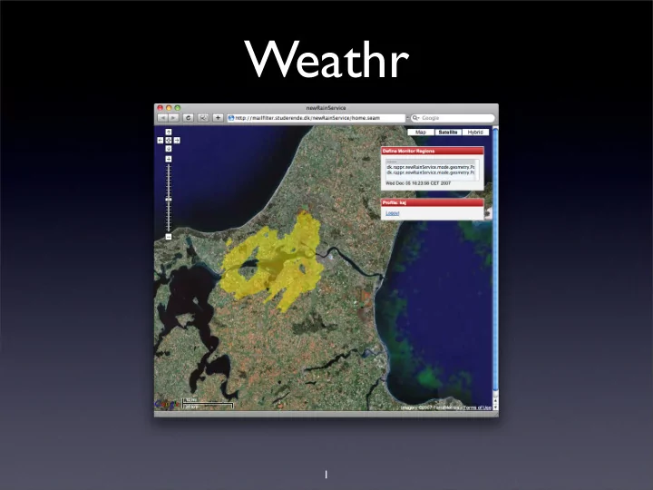
memory and SCSI drives running a JBoss AS at: http://mailfilter.studerende.dk/newRainService/

10

slide-11
SLIDE 11

Components

  • Main Controller
  • Data Monitor Component
  • Data Access Layer
  • StreamSpin Component
  • Versatile parse mechanism with callback

events

  • Spatio Temporal Data Access Layer

11

slide-12
SLIDE 12

Data Monitor Component

  • Initialized automatically when framework itself has concluded

initialization leveraging the EJB Timer mechanism

  • Polls remote store via SFTP for new incoming data with a given

interval (10 secs)

  • On new available data, file is downloaded and datareceived

notification is emitted

  • Executed in separate thread
  • Application Scoped

12

slide-13
SLIDE 13

Weathr Controller Component

  • Responsibility of the general application

flow dealing with monitoring and actions

  • n incoming data
  • Observes the monitor for new data and

initiates initial parsing registering relevant callback handlers:

  • Image generation (saves png image to disk for the UI)
  • User profile querying (querying all saved profile geometries on parse time)
  • ADT generation and registration

(user provides a query to the system)

13

slide-14
SLIDE 14

Data Access Layer Component

  • For storage and retrieval of historic data
  • Employs a DAO style architecture for data-access

implementing a common data access generic typed interface.

  • Date range selects, returning the single nearest in time
  • Singe point in time with a given +/- threshold, returning single nearest

in time

  • Select specific dataitem given some ID (eg. filename or integer value).

Must be defined through generic type argument

  • Insert (save)
  • Currently only a FileSystemWeatherGridDAO is

fully implemented, and a generic DBMS is partially present.

14

slide-15
SLIDE 15

DBMS ...... Filesystem Data Access Component

...... Connector FileSystem Connector Database Connector

Registered Grid File ContentHandlers Grid Data Stream Parser <T extends AbstractWeatherGrid

15

slide-16
SLIDE 16

Parser

  • Versatile Grid stream parsing mechanism using

callback handlers

  • Heavily inspired by SAX for stream based XML

parsing.

  • Parser Interface describes only one method

parse(InputStream is, ContentHandler ch)

  • Each implemented parser must call 4 methods on the

ContentHandler at given stages of the parsing process

  • startDocument(), endDocument(),

metaValuesProcessed(GridMetaData gmd), cellValueEncountered(int x, int y, byte value)

16

slide-17
SLIDE 17

WeatherGrid ContentHandler ...ContentHandler parse(InputStream is, ContentHandler[] ch) : void <<Interface>> GridParser documentStart() : void metaDataProcessed(int noCellsX, int noCellsY) : void cellValueEncountered(int x, int y, byte[] value) : void documentEnd() : void <<Interface>> ContentHandler TextGridParser BinaryGridParser <<argument>>

Parser w/ callback event-mechanism

Customizing behaviour at parse time

StreamQueryHandler(ResultHandler rh)

  • criteria : FilterCriteria

StreamQueryHandler Query on parse time Construct In-Memory Weathergrid

17

slide-18
SLIDE 18

StreamSpin Component

  • Handles all communication with the

Streamspin service. Incoming and outgoing.

  • Dispatches incoming user locations
  • Submission of user messages
  • Creates new service and signs up user for

submission, submits message and destroys service

18

slide-19
SLIDE 19

Needs to be done

  • Constrained by unknown factor regarding provision of

forecasts in realizing a true service.

  • More specialized Data Access Layer which suits on top of
  • ur own Query engine and the possibility of delegating

queries to a DBMS leveraging fx. Oracle Spatial and GeoRaster or any other through eg. Stored Procs.

  • Treats our query engine as a Source of Data.
  • Interface is partially defined:
  • getGridsWithRain(Geometry geom, [int minutesInAdvance])
  • isRaining(Geometry geom, [int minutesInAdvance]);

19

slide-20
SLIDE 20

Future version

  • Statistical queries on historic data. Wrapping data access

layer must implement methods such as:

  • getRainOnGeometry(Geometry geom, Date from, Date to)
  • getAvgRainOnGeometry(Geometry geom, Date from, Date to)
  • ...

20

slide-21
SLIDE 21

ADTs

21

slide-22
SLIDE 22

Weather Radar

Frequency [MHz] 9410 ± 30 MHz Output Power [kW] 25 Maximum range [km] 60 km Grid resolution (pixel size) [meter] 500x500(60 km range) 250x250 (30 km range) 300x300 (15 km range) 100x100 (15 km range) Image Frequency [minutes] 1 or 5 Antenna- Slotted wave guide [m] 2.44 Horizontal beam width (BWH) 0.95° Vertical beam width (BWV) (measured from horizontal) ±10° Rotation Speed [rpm] 24 Power consumption [kWh/ year] 5700

22

slide-23
SLIDE 23

Data Set

  • Data set of 240×240 fields (57600)
  • Precipitation is specified as a numeric value

ranging from 1 to 255

  • No precipitation is expressed by the

numeric value zero (0)

  • A new data set is received each five

minutes through an FTP connection

23

slide-24
SLIDE 24

Data Set Statistical Analysis

  • Close to three weeks of data sets have been

analyzed:

  • 72,4% of the rows consist of all zeros
  • 97,2% of the fields in a data set contains a zero
  • 1,8% of the data sets is a complete set of zeros
  • Some noise values occur

24

slide-25
SLIDE 25

Stream Spin Weathr Service

240 240 15

25

slide-26
SLIDE 26

ADT: Grid

  • byte[][][]
  • x-axis (North-South)

— currently 240

  • y-axis (East-West)

— currently 240

  • Time intervals

(Forecasts) — currently 15

240 240 15

26

slide-27
SLIDE 27

ADT: Hash Map

  • HashMap <Key,Value>
  • <Key> consists of a coordinate pair (x,y), specifying location in

the weather grid

  • <Value> consists of an array of bytes. The array describes the

precipitation in a single cell in time

  • Number of forecasts [15, 70 minutes into the future]
  • Forecast interval [5 minutes]

Minutes 0 1 2 3 4 5 6 7 8 9 10 11 12 13 14 Precipitation - 2 23 58 93 72 41 11 -

  • 12

27

slide-28
SLIDE 28

Performance Studies

  • Space vs. precipitation concentration of ADTs
  • Performance
  • Single-cell queries.
  • Route (multiple cells) queries
  • Polygon queries for the various ADTs
  • Polygon, cell vs. MBR
  • Caching queries
  • Caching precipitation data

28

slide-29
SLIDE 29

Related Work

  • Different spatial query types:
  • Stationary queries on moving objects
  • Moving queries on stationary objects
  • Moving queries on moving objects
  • We differ since our data is always complete
  • No prediction is necessary
  • There are no moving objects

29

slide-30
SLIDE 30

Related Work

  • Main memory: Implementation of data

structures in main memory

  • Sparse data: Sparse data is by nature easily

compressed

  • 97,5% zero cells
  • 72,4% zero-rows (October 2007)

30

slide-31
SLIDE 31

Related Work

  • Space filling curves:
  • Curve that visits every point/cell in a

space

  • Maps multidimensional data to one

dimension.

  • Map e.g. (x,y) to a derived key:

(110,100) ⇒ 101110

31

slide-32
SLIDE 32

Related Work

  • Other indices to index spatial data:
  • B-trees
  • B+-trees
  • R-trees (MBR)

32

slide-33
SLIDE 33

Related Work

  • Other Similar projects:
  • IBM Thomas J. Watson Research Center:

Visualization of data from a weather simulation

  • Departement de Linguistique Universite

de Montreal has researched in synthesizes marine weather forecasts

33

slide-34
SLIDE 34

Status

  • The application: Nearing “completion”
  • Article outline:
  • Introduction, related work, software

architecture and implementation, StreamSpin, ADTs, performance study, conclusion, and future work

34

slide-35
SLIDE 35

Future Work

  • Statistics on historical data using a DBMS

back-end

  • In-memory solution is infeasible
  • E.g. a farmer wants to monitor the

amount of rainfall his land has received

  • Oracle provides GeoRaster for raster

(grid) data

35

slide-36
SLIDE 36

Future Work

  • Support for multiple radars
  • Handle overlapping data grids
  • Scalability
  • Variable grid cell size

36

slide-37
SLIDE 37

Feedback

  • We would appreciate feedback on:
  • Abstract data types
  • Related work (anything comes to mind?)

37