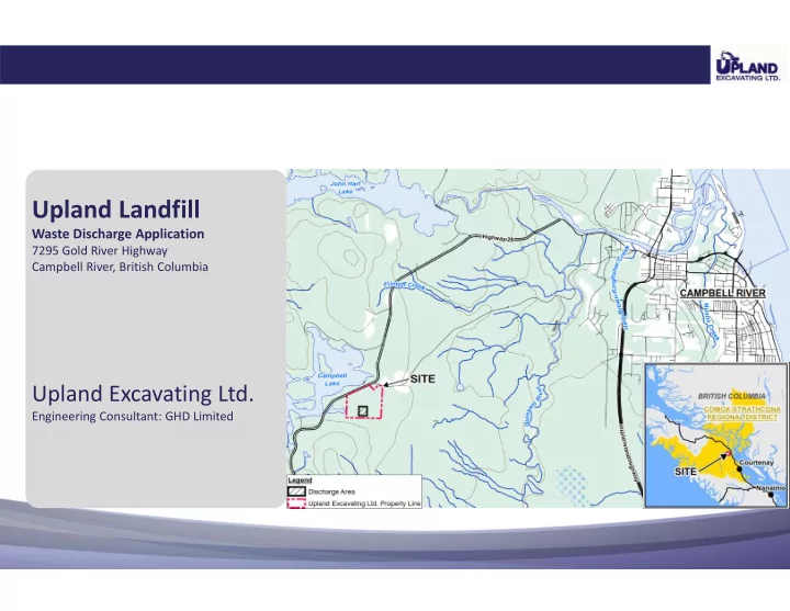
upland landfill
play

Upland Landfill Waste Discharge Application 7295 Gold River Highway - PowerPoint PPT Presentation

Upland Landfill Waste Discharge Application 7295 Gold River Highway Campbell River, British Columbia Upland Excavating Ltd. Engineering Consultant: GHD Limited Presentation Agenda Project Background Site Plan and Environmental Controls


  1. Upland Landfill Waste Discharge Application 7295 Gold River Highway Campbell River, British Columbia Upland Excavating Ltd. Engineering Consultant: GHD Limited

  2. Presentation Agenda Project Background • Site Plan and Environmental Controls • Landfill Design • Additional Information Developed • Additional Investigations and Studies • Updated Hydrogeologic and Hydrologic Characterization • Conceptual Site Model •

  3. Background ‐ Upland in the Community Upland Group is one of the largest and most diverse construction companies on Vancouver Island. Active member of the Campbell River community and economy since 1969. Upland Group strives to maintain a solid reputation for providing a professional work ethic with honest, trustworthy employees and management. Constantly looking for new, more efficient methods and equipment to meet the needs of the clients and community. Operations include: • Gravel extraction, custom crushing, aggregate supply • Highway, road, subdivision construction • Logging road construction • Spawning channel restoration • Hydroelectric construction • Pipe line and mining construction • Land reclamation • Concrete production • Construction, demolition, and land clearing disposal • Asphalt and concrete recycling

  4. Background ‐ Project Overview Existing Permit PR ‐ 10807 (June 2, 1992) • Waste Discharge Application submitted May 27, 2016 to the MOE for an Operational Certificate • Design and Operated as per Landfill Criteria for Municipal Solid Waste, Second Edition (June 2016) • Landfill to receive only non ‐ hazardous solid waste: • Construction and demolition waste • Land clearing debris • Non ‐ hazardous contaminated waste soil • Material recovery/recycling: • Clean wood • Asphalt • Concrete • Steel • Upgraded Landfill Approximate Site life: • 20 years • 500,000 cubic metres of capacity •

  5. Site Plan and Environmental Controls Lined Cells near Centre of • Property Leachate Treatment System to • East including: Aeration pond • Contingent settling pond • Infiltration pond • Treated leachate quality will • meet applicable Schedule 6 Drinking Water Standards Groundwater Monitoring • locations are located throughout the Site Water quality at the property • boundary will also meet applicable Schedule 6 Drinking Water Standards

  6. Leachate Collection System and Base Liner The landfill will have a base liner system composed of (from • bottom to top): Compacted native ground • Geosynthetic clay liner • HDPE geomembrane liner • Non ‐ woven geotextile • Leachate collection pipes within a granular drainage • blanket Woven geotextile • The base of the landfill will be sloped to convey leachate to a • single sump location for extraction and treatment

  7. Landfill Final Contours Vegetated, Sand and Geosynthetic • Clay Liner Cover 3H:1V Side Slopes • 10H:1V Top Plateau • Landfill Disconnected from Pit Walls • Except on lined Southern • Slope Surface Water Diversion Berm • Constructed on top of • excavation to prevent run ‐ on from south of Landfill outside of aggregate pit Surface Water from Closed Landfill • Conveyed to base of pit for • infiltration

  8. Additional Information Developed • Compliance with June 2016 Landfill Criteria • Landfill Criteria Compliance Checklist • Increase Hydrogeologic and Hydrologic Characterization • Four monitoring wells installed between Site and McIvor Lake • A downgradient monitoring well installed • Additional hydraulic monitoring completed • Watershed divide refined with additional topographic survey data • Test pits and survey to map near surface bedrock • Include additional Monitoring Wells in Environmental Monitoring Plan • Environmental Monitoring Program Updated Confirmation /Assessment of Applicable Water Quality Standards and Guidelines • Registered Professional Biologist retained to assess presence of Aquatic Receptors •

  9. Additional Information Developed (Cont.) Financial Security • Financial Security Plan Developed in accordance with Landfill Criteria • Location and Volume of Existing Waste • All non ‐ recyclable waste to be relocated to lined landfill • Existing location and approximate volume determined • Provision of Leachate Level Monitoring • Environmental Monitoring Program Updated • Leachate level monitoring part of 2017 Design, Operation, Closure Plan • Calculation of Permit Fees • Permit fee for discharge of waste and treated leachate calculated for Stage 1 •

  10. Additional Investigations and Studies 5 Additional Monitoring Wells • Additional Groundwater and Surface Water • Monitoring 9 Test Pits and Bedrock Outcrop Survey to Map • Bedrock Ridge Hydraulic Monitoring to Confirmed Gradients • Refined Location of Watershed Divide • Updated Site Impact Assessment • Aquatic Receptor Assessment Completed • Assessed and Confirmed Applicable Water Quality • Updated Conceptual Site Model •

  11. Bedrock Contours

  12. Overburden Groundwater Contours

  13. Regional Watersheds

  14. Refined Watershed Divide

  15. Conceptual Site Model (West to Southeast)

  16. Conceptual Site Model (North ‐ Southeast)

Download Presentation
Download Policy: The content available on the website is offered to you 'AS IS' for your personal information and use only. It cannot be commercialized, licensed, or distributed on other websites without prior consent from the author. To download a presentation, simply click this link. If you encounter any difficulties during the download process, it's possible that the publisher has removed the file from their server.

Recommend


More recommend