UAV Presentation Bill Timmins GIS Services UAV copters can provide - - PowerPoint PPT Presentation

uav presentation
SMART_READER_LITE
LIVE PREVIEW

UAV Presentation Bill Timmins GIS Services UAV copters can provide - - PowerPoint PPT Presentation

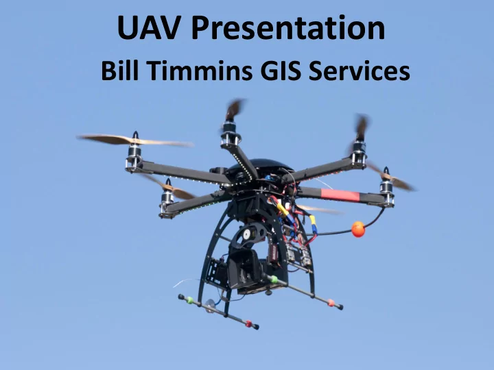
UAV Presentation Bill Timmins GIS Services UAV copters can provide for a variety of sensors for solution requirements. Flight time depends on payload weight, temperature and alititude . UAV Unmanned Aerial Vehicles It is an aircraft


slide-1
SLIDE 1

UAV Presentation

Bill Timmins GIS Services

slide-2
SLIDE 2

UAV copters can provide for a variety of sensors for solution requirements. Flight time depends on payload weight, temperature and alititude .

slide-3
SLIDE 3

UAV

  • Unmanned Aerial Vehicles

– It is an aircraft without a human pilot on board. Its flight is controlled either autonomously by computers in the vehicle, or under the remote control of a pilot on the ground or in another

  • vehicle. Wikipedia
  • Also known as drone, remotely piloted

Vehicle (RPV), remotely piloted aircraft (RPA), or remotely operated aircraft (ROA)

slide-4
SLIDE 4

Types of UAVs (not)

slide-5
SLIDE 5

Rules

  • Recreational or Sport Use

– These "limited-size" unmanned aircraft flown in the USA‘s National Airspace System, flown solely for recreation and sport purposes such as models. These are generally flown under the voluntary safety standards of the Academy of Model Aeronautics which is the US national aero modeling organization.

  • Non-Recreation Use

– To operate a UA for non-recreational purposes in the United States, users must obtain a Certificate of Authorization (COA) to operate in national airspace. At the moment, COAs require a public entity as a sponsor.

slide-6
SLIDE 6

Types of Civilian UAVs

  • Copters
  • Planes (fixed wing)
slide-7
SLIDE 7

Copter Uses

  • Events

– Real time evaluation of a location – Emergency Response

  • Aerial Photography (AP)

–Usually for small areas – Can provide high resolution imagery

slide-8
SLIDE 8

Training

  • Typically it is recommended that
  • rganizations purchase a training copter

before using one for Aerial Photography

  • r real time event response
  • The majority of Aerial Photography
  • perations will have preset flight plans.
slide-9
SLIDE 9

Copter Example for Aerial Photography

  • 20 Mega Pixel Camera
  • Remote Control
  • GPS, Flight Planning Software; and
  • Post Processing Aerial Photo Software.
slide-10
SLIDE 10

Aerial Photography Examples

Typical Photograph Oblique Photograph

slide-11
SLIDE 11

Flight Specifications for Inexpensive Copter Solutions for Event Response ($5K to $10K)

  • Flight time 15 to 20 minutes
  • Batteries switch out easily
  • Camera with viewing goggles (light

and powerful – such as GoPro)

  • Interchangeable lens
slide-12
SLIDE 12

Mission Planning Example

  • Copters auto-compensates for wind
slide-13
SLIDE 13

Aerial Photography

  • Post Processing
slide-14
SLIDE 14

Aerial Photography Maricopa County Flood Control Example

  • Surface Modeling provided 6mm vertical accuracy

flying at 100 feet.

slide-15
SLIDE 15

Detail Surface Modeling

slide-16
SLIDE 16

GPS MODULE

The plug and play GPS module will greatly enhance the performance for Aerial Photography providing: Accurate Position Hold, Return-To-Home and Intelligent Orientation Control functionalities. With the GPS Module, the multi-rotor will have position and altitude locked accurately even in windy conditions.

slide-17
SLIDE 17

Copters for Events

  • Can carry video cameras
  • Provide GPS locations
  • Real-time video to:

–Tablets –Phones –Computers

  • Using a remote control you can manually

capture situational awareness or use preplanned flight plans and/or waypoints

  • r determine your areas of interest and

plan your flights and capture.

slide-18
SLIDE 18

Mobile Copter Pack Custom Designed for AZ Counter Terrorism Information Center

  • Transmitter
  • Antennae
  • Batteries
  • Goggles
  • Remote Control
  • Backpack
slide-19
SLIDE 19
slide-20
SLIDE 20

Site Reconnaissance – Superior AZ

slide-21
SLIDE 21

GeoBlu Explorer Quad

  • Complete Set Up - Bench/Flight Tested and Tuned
  • GPS, Return Home, Intelligent Orientation Control
  • Flight Controller
  • GoPro Hero 3 Black Edition - 16GB Class10 MicroSD Card
  • Brushless Motor Stabilized Camera Gimbal for GoPro
  • Pelican Travel Case
  • 2 Flight Batteries
  • Battery Charger
  • Live View Goggles
  • Video transmitter
  • Battery Level Checker
  • 2 sets - extra props
  • Flight Training –

Pre/Post Flight Training

slide-22
SLIDE 22

Questions?

Bill Timmins Office 520-795-1162 Mobile 520-991-0727 Info@GISServices.net