
SLIDE 1
Topics View from our HAB at 90.000+ ft. Project Goals Actual - - PowerPoint PPT Presentation
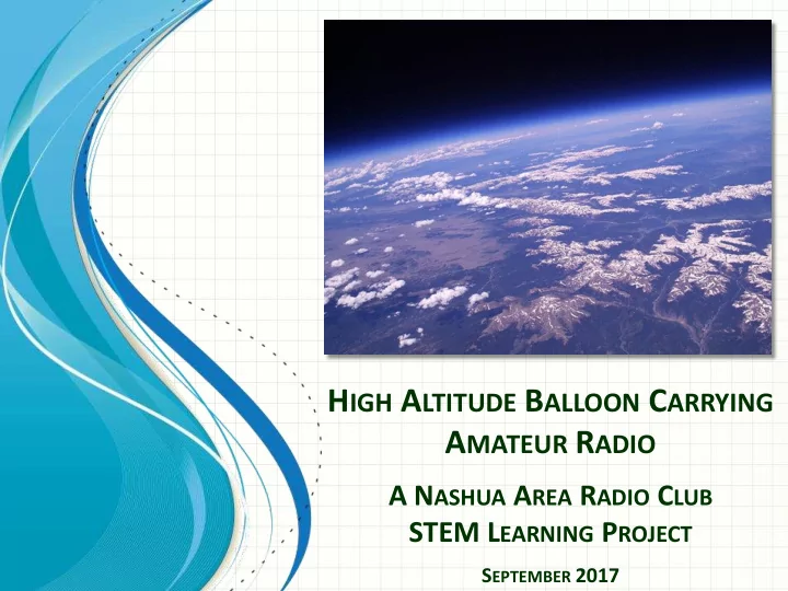
H IGH A LTITUDE B ALLOON C ARRYING A MATEUR R ADIO A N ASHUA A REA R ADIO C LUB STEM L EARNING P ROJECT S EPTEMBER 2017 Topics View from our HAB at 90.000+ ft. Project Goals Actual Flight Path Analysis STEM Learning Elements Our
2
Not to Scale
View from our HAB at 90.000+ ft.
3
Not to Scale
Balloon Just Before Burst
4
Not to Scale
Project Start Minimum Funding
Set Launch Date & Site Phase I Launch!
Analyze, Learn and Present Build & Launch! Detailed Planning Funding Feasibility Startup Planning
Refine Budget
Package & Plan Youth Engagement Plan/School Signup Raise Money Form Youth Teams & Set Final Goals/Plan Purchase Equipment Begin Phase I Build & Test Data Analysis, Preso, Prep & Presentations
Youth Teams In Place
Late May, Early June
March 2nd
Project Launch Go/No Go
5
Not to Scale
Bishop Guertin HS STEM Club Merrimack HS Physics Students Independent Students
6
Not to Scale
additional launches after the initial one
7
Radio Telemetry and Sensor Technology Filing a Flight Plan
Open House at Member’s Station to Test HAB and Explore Amateur Radio Taught Over Five 1 ½ – 2 hour Classroom Sessions
8
at the surface and thins rapidly with altitude.
weight of the molecules above you.
atmosphere is below you.
Burst
HAB Sensors Measure Pressure Enabling Students to Compare Actual Flight Conditions to Model
9
Not to Scale
Earth’s surface because heat from the Earth warms this air.
molecules decreases, thus the average of their kinetic energy decreases. The results is a decrease in air temperature with an increase of altitude.
This region is called the tropopause.
is concentrated in this layer and it absorbs UV light from the Sun.
compared to the lower stratosphere, so the temperature increases.
Burst
HAB Sensors Measure Temperature Enabling Students to Compare Actual Flight Conditions to Model
– 1 km = 0.54 nautical mi.
10
11
12
Not to Scale
13
Not to Scale
14
15
16
155
Average ascent speed Burst altitude Descent rate (at impact) Launch date and time Define launch location
17
18
2017-04-07 21:16:50 EDT: N1FD-11>CQ,WIDE1-1,WIDE2-2,qAR,NX1W:!4242.70N/07135.41WO148/000/A=000351RadBug,16C,984mb,3,001 2017-04-07 21:17:50 EDT: N1FD-11>CQ,WIDE1-1,WIDE2-2,qAR,AB1OC-10:!4242.70N/07135.41WO148/000/A=000354RadBug,10C,984mb,3,002 2017-04-07 21:18:50 EDT: N1FD-11>CQ,WIDE1-1,WIDE2-2,qAR,NX1W:!4242.70N/07135.41WO148/000/A=000360RadBug,08C,985mb,3,003 2017-04-07 21:19:50 EDT: N1FD-11>CQ,WIDE1-1,WIDE2-2,qAR,AB1OC-10:!4242.70N/07135.41WO148/000/A=000360RadBug,06C,985mb,3,004 2017-04-07 21:20:50 EDT: N1FD-11>CQ,WIDE1-1,WIDE2-2,qAR,NX1W:!4242.70N/07135.41WO148/000/A=000347RadBug,05C,985mb,3,005 2017-04-07 21:21:51 EDT: N1FD-11>CQ,WIDE1-1,WIDE2-2,qAR,NX1W:!4242.70N/07135.41WO148/000/A=000344RadBug,05C,985mb,3,006 2017-04-07 21:22:51 EDT: N1FD-11>CQ,WIDE1-1,WIDE2-2,qAR,NX1W:!4242.70N/07135.41WO174/000/A=000347RadBug,04C,985mb,3,007 2017-04-07 21:23:51 EDT: N1FD-11>CQ,WIDE1-1,WIDE2-2,qAR,NX1W:!4242.70N/07135.41WO174/000/A=000344RadBug,04C,985mb,3,008 2017-04-07 21:24:51 EDT: N1FD-11>CQ,WIDE1-1,WIDE2-2,qAR,NX1W:!4242.70N/07135.41WO325/000/A=000347RadBug,04C,985mb,3,009 2017-04-07 21:25:52 EDT: N1FD-11>CQ,WIDE1-1,WIDE2-2,qAR,NX1W:!4242.70N/07135.41WO325/000/A=000351RadBug,04C,985mb,3,010 2017-04-07 21:26:52 EDT: N1FD-11>CQ,WIDE1-1,WIDE2-2,qAR,AB1OC-10:!4242.70N/07135.41WO325/000/A=000351RadBug,04C,985mb,3,011 2017-04-07 21:27:52 EDT: N1FD-11>CQ,WIDE1-1,WIDE2-2,qAR,NX1W:!4242.70N/07135.41WO325/000/A=000351RadBug,04C,985mb,3,012 2017-04-07 21:28:51 EDT: N1FD-11>CQ,WIDE1-1,WIDE2-2,qAR,NX1W:!4242.70N/07135.41WO325/000/A=000351RadBug,04C,985mb,3,013 2017-04-07 21:29:52 EDT: N1FD-11>CQ,WIDE1-1,WIDE2-2,qAR,AB1OC-10:!4242.70N/07135.41WO109/000/A=000351RadBug,04C,985mb,3,014 2017-04-07 21:30:51 EDT: N1FD-11>CQ,WIDE1-1,WIDE2-2,qAR,NX1W:!4242.70N/07135.41WO109/000/A=000347RadBug,04C,985mb,3,015 2017-04-07 21:31:51 EDT: N1FD-11>CQ,WIDE1-1,WIDE2-2,qAR,NX1W:!4242.70N/07135.41WO109/000/A=000351RadBug,04C,985mb,3,016 2017-04-07 21:32:51 EDT: N1FD-11>CQ,WIDE1-1,WIDE2-2,qAR,NX1W:!4242.70N/07135.41WO266/000/A=000360RadBug,04C,985mb,3,017 2017-04-07 21:33:51 EDT: N1FD-11>CQ,WIDE1-1,WIDE2-2,qAR,NX1W:!4242.70N/07135.41WO266/000/A=000360RadBug,04C,985mb,3,018 2017-04-07 21:34:51 EDT: N1FD-11>CQ,WIDE1-1,WIDE2-2,qAR,NX1W:!4242.70N/07135.41WO266/000/A=000360RadBug,04C,985mb,3,019 2017-04-07 21:35:51 EDT: N1FD-11>CQ,WIDE1-1,WIDE2-2,qAR,NX1W:!4242.70N/07135.41WO269/000/A=000364RadBug,04C,985mb,3,020 2017-04-07 21:36:51 EDT: N1FD-11>CQ,WIDE1-1,WIDE2-2,qAR,NX1W:!4242.71N/07135.41WO269/000/A=000367RadBug,08C,985mb,3,021 2017-04-07 21:37:52 EDT: N1FD-11>CQ,WIDE1-1,WIDE2-2,qAR,AB1OC-10:!4242.71N/07135.41WO045/001/A=000364RadBug,13C,984mb,3,022 2017-04-07 21:38:52 EDT: N1FD-11>CQ,WIDE1-1,WIDE2-2,qAR,AB1OC-10:!4242.71N/07135.41WO056/000/A=000367RadBug,15C,984mb,3,023
19
Predicted Flight Path from Pre-Flight Modeling Actual HAB Flight Track (Tracked via Cell Phones, Tablets, anything with a Web Browser)
Predicted Landing Pt.
20
Not to Scale
21
Nashua Area Radio Club HAB Project Team Members: