st george s barracks
play

St George's Barracks Manton Residents Draft Discussion Document 31 - PowerPoint PPT Presentation

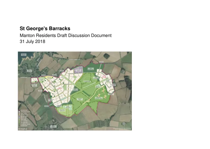
St George's Barracks Manton Residents Draft Discussion Document 31 July 2018 St Georges Barracks Proposal: 300 hectare site 70 houses on Officers Mess Site 3,000 houses on the western development plot 500 houses in the Future


  1. St George's Barracks Manton Residents Draft Discussion Document 31 July 2018

  2. St Georges Barracks Proposal:  300 hectare site  70 houses on Officers Mess Site  3,000 houses on the western development plot  500 houses in the Future Satellite Settlement  14 hectares of employment  New Primary School  Local Centre  180 hectares (60%) green space

  3. Scale: (urban mass)  Oakham 346 hectares  Uppingham 111 hectares  St Georges 113 hectares (excludes satellite village)  Manton 15 hectares

  4. Main Issues  Whilst there is an overall issue regarding the scale of development, it's character and the need for such a development, the visual impact will not be significant for Manton.  The key issue and impact on the village will be traffic, noise and air quality.  This would apply to construction traffic, quarrying? and traffic generation from the development itself.  The main visual impact would be a new roundabout on the A6003. This may be a positive for the village.

  5. Housing Need  The Strategic Housing Market Assessment (SHMA) update 2017 established a need in the County for 3,200 new dwellings from 2011 to 2036 based on a delivery rate of 160 dwellings per annum.  Whilst St Georges Barracks could deliver 3,570 homes in total an assumption has been made in the Draft Local Plan that only 1,200 dwellings will be delivered in the plan period (up to 2036). This is based on a delivery rate of 100 units per annum from 2024 to 2036. The balance will be delivered beyond the current plan period. Table 1: Proposed Spatial Distribution across the County 2. Table 2: Comparison of the Revised Housing Requirement proposed in this paper and the Consultation Draft Plan (2017) requirements  This effectively means that there will be a reduction in development elsewhere in the County as indicated in the table below which could be seen as a positive factor.

  6. Employment Baseline  The Rutland County Council Employment Land Assessment Update - Final Report Jan 2016 assesses the supply, need and demand for employment land in Rutland up 2036.  The report suggests that an additional 29.09 HA of employment land is required up to 2036.  St Georges could supply 14 hectares of this.  The proposed mix (in the Transport Assessment) at St Georges is: B1 (offices) 25% B2 (Light Industrial) 40% B8 (Distribution) 35%

  7. Masterplan Analysis

  8. Use Area Required Actual Area Notes Overall Site Area 300 HA 300 HA Includes Officers Mess Site 60% Public Open Space 180 HA 195.8 HA The 195.8 HA is based on the drawn masterplan which has a shortfall in (only 160 HA housing and employment of 37 HA. If achievable if this is corrected to take up the Eastern Area shortfall and omitting the eastern delivered) housing 180 acres are achieved. Officers mess site 2.4 HA 2.4 HA Delivers 70 houses at 2.9/HA Western Area 3,000 homes 103.5 HA 73HA This is a shortfall of 28 HA which, at at 29 dwellings/hectare 29/HA, accommodates only 2,117 dwellings (To achieve 3,000 homes a (excluding officers mess) density of 41/HA would be needed). Eastern Area 500 homes at 17.2 HA 20 HA Adequate provision for 500 homes 29 dwellings/hectare Employment Zone 14 HA 5.0 HA A shortfall of 9 HA. At standard development densities (17,500sqft/ac) this equates to a shortfall in employment floorspace of 390,000 sq ft. School 2.3 HA 2.3 HA Local Centre 1.5 HA 1.5 HA SUDS (Sustainable Urban None None 4.5 ha of land will be required to Drainage) achieve greenfield run-off rates based on 15m3/dwelling.

  9. Quantum of Development - Housing  The High-Level Masterplan sets out a target of 3,570 homes on the St Georges Barracks Site. 70 on the former Officers Mess, 3,000 on the western site and an additional future 500 on the eastern satellite village.  To achieve 3,000 dwellings at 29 dwellings per hectare 103.5 hectares of development land will be required. Only 73 hectares are shown on the masterplan. This would provide 2,190 dwellings. The difference between actual and required land (30.5 hectares - or an area larger than Edith Weston) is shown on the overlay below.

  10. Quantum of Development - Employment  The High-Level Masterplan refers to employment as a key element of the scheme to ensure that the development is sustainable.  The Masterplan states an area of 14 hectares (34.5 acres) should be provided. At average commercial densities (and based on the Traffic Assessment) this would give 61,200m2 (650,000 sq ft) of commercial development.  The masterplan states the aspiration to create one job per household. A total of 3,570 new jobs.  As illustrated below only 5 hectares of employment space is shown on the masterplan. A shortfall of 9 hectares. At average commercial densities this would equate to a shortfall of 39,342 m2 (423,000 sq ft).

  11. Drainage  To comply with current government guidance on flood prevention new developments must attenuate surface water runoff so that the discharge matches a standard greenfield discharge. This prevents rapid fluctuations in surface water flow through a greater discharge from hard surfaces such as roads and roofs. As a rule of thumb an allowance of 15m3 per house should be allowed which is an area of 4.5 hectares.  As the site is a former airfield it is likely that the high point of the site is the centre of the runways so effectively the centre of the site. As attenuation ponds need to be located at the low points these may impact on the location of the housing. No information on drainage strategy (foul and storm) seems to be contained within the documentation. Transport  A Transport Assessment (TA) was prepared for St Georges in April 2018 and contains an assessment of the existing traffic situation, the assumptions on trip generation from the new development, distribution of traffic and predicted traffic generation post development.  Traffic will be one of the key factors impacting on Manton and its impact needs to be fully understood. The TA needs to be reviewed in detail and assessed to understand the impact on the existing highway network, the rural character of the roads and tourism (cycling etc). Affordable housing  Whilst affordable housing is mentioned there does not appear to be a percentage established in the available documentation. Establishing a minimum should be a key consideration.

  12. Next Steps  Develop a coherent plan and a consistent message to enable the group to respond to the consultation timescales.  It seems that there are three key options available: 1. Fight for no development at all (unlikely to succeed) 2. Accept the scale of development but ensure safeguards are in place to control development and ensure that the infrastructure, affordable housing, employment targets etc are met. 3. Push for a development of a scale which compliments, and does not have an adverse impact on, the County (this seems to be the favoured approach from Edith Weston and North Luffenham) If a smaller 500 unit scheme were proposed it would be of a scale which complimented rather than overshadowed Edith Weston as illustrated below.

  13.  The St George's proposals have been through a range of public consultations, including a recent public exhibition in Manton. At the same time RCC are bringing forward an updated Local Development Plan (LDP) extending the plan period to 2036. This is now working its way through the consultation process. The new LDP will incorporate the St George's Development into it. The timescale is broadly set out below. Anticipated Date Process 31st July cabinet Report RCC are carrying out an additional non-statutory consultation to consider the implications of including St George's Barracks into the LDP. Consultation opens 13th Consultation Period 6 weeks August closes 24th sept Nov / Dec 2018 LDP Published. The LDP will be available for a minimum of 6 weeks for public comment Early 2019 If the plan is considered sound RCC can submit to the Planning Inspectorate. 2019/2020 The plan is examined by an independent planning Inspector, normally at a public hearing. 2020 If the Inspector finds the plan to be sound it can be adopted by the local Authority. 2020/2021 Following adoption of the plan it is likely that the developer will submit an outline planning application to establish the principles and quantum of development. 2020/2021 Once the outline application is determined individual development plots / phases will be submitted as reserved matters applications.  The first key milestone is to prepare representations to the non-statutory consultation by the 24th September.

Download Presentation
Download Policy: The content available on the website is offered to you 'AS IS' for your personal information and use only. It cannot be commercialized, licensed, or distributed on other websites without prior consent from the author. To download a presentation, simply click this link. If you encounter any difficulties during the download process, it's possible that the publisher has removed the file from their server.

Recommend


More recommend