Spatial navigation in humans (mostly) Sensing the world with - - PDF document
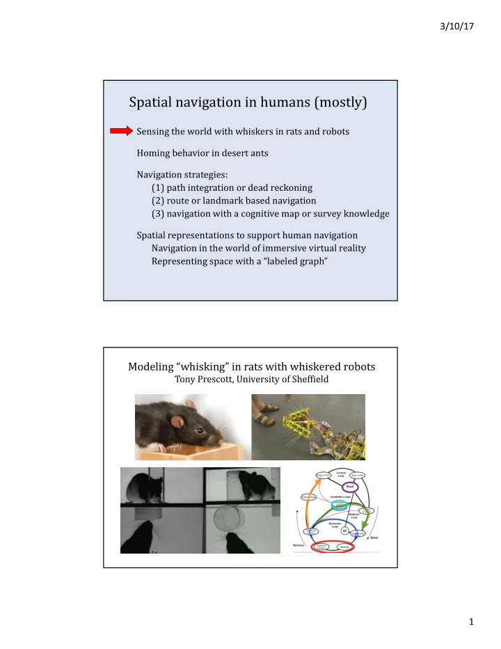
3/10/17 Spatial navigation in humans (mostly) Sensing the world with whiskers in rats and robots Homing behavior in desert ants Navigation strategies: (1) path integration or dead reckoning (2) route or landmark based navigation (3)
3/10/17 2
nest food homeward path search path
Homing behavior in desert ants
Desert ants compute straight path home after circuitous outward path Location represented in 2D or 3D space? “… desert ants must have developed some other cognitive mechanism to find their way back home” Do ants count steps?
Scientific American, The Thoughtful Animal
Spatial navigation in humans (mostly)
Sensing the world with whiskers in rats and robots Homing behavior in desert ants Navigation strategies: (1) path integration or dead reckoning (2) route or landmark based navigation (3) navigation with a cognitive map or survey knowledge Spatial representations to support human navigation Navigation in the world of immersive virtual reality Representing space with a “labeled graph”
3/10/17 3
Path integration (aka dead reckoning)
- update distance and direction traveled from a starting point
- standard test for path integration ability: triangle completion task
Route or landmark based navigation
- remember specific sequences of positions, turns, landmarks, junctions
- series of place-action associations
- detours can be challenging if only use remembered routes
Navigation guided by a cognitive map or survey knowledge
- map may encode metric distances and angles between objects
- enables novel shortcuts, general route planning
- but routes still helpful to avoid constant planning from map
- path integration and routes can be used to build cognitive map
Navigation strategies
- immersive virtual reality gives subjects a realistic interactive environment
- subject moves freely in a 12m x 12m room
- 3D location and orientation is tracked continuously, visual input updated
- cues: stereo/motion vision, proprioception, vestibular
Spatial navigation with immersive virtual reality
3/10/17 4
It has often been suggested that... When learning the layout of a new environment, humans first learn particular routes to important locations, then gradually build up survey knowledge of the environment Many researchers have assumed that... We ultimately build a cognitive map that captures metric information about distances and angles Questions: Foo, Warren, Duchon & Tarr (2005, 2007) Do humans integrate route-based knowledge into survey knowledge of environmental layout? If so, what is the geometric structure of this spatial knowledge?
- do we represent metric properties e.g. distances, angles between
known locations?
- or “weaker” geometric knowledge of layout?
From route knowledge to survey knowledge?
Do humans combine traveled routes into a survey representation that permits metric navigation in the environment?
- two virtual worlds: desert or forest (8 subjects each)
- subjects learn two paths (home-blue, home-red) to
remembered target locations, with fixed angle between the paths, until consistent, high accuracy
- after training, walk novel shortcut between endpoints
- if subjects represent metric information about distances
and angles, should accurately walk novel shortcut
- if subjects rely on landmarks, expect more accurate
performance for forest scene
3/10/17 5
Do humans build survey knowledge from learned routes? Does such survey knowledge preserve metric distances, angles?
Desert: initial bearing and distance to target was good for practiced legs, but large accumulated errors over path, not accurate shortcuts, undershoot turning angle and distance, no corrections Forest: greater accuracy in reaching targets for both practiced paths and shortcuts, midcourse corrections
Without landmarks, humans cannot accurately perform simple shortcuts, spatial knowledge does not support navigation based on survey knowledge
- f metric distances, angles
- same task as before
- virtual world: desert with 7 posts
- after training, translate or rotate posts
near red target, on some trials (different subject groups)
- landmarks near start of shortcut
helped initial bearing, but then large errors accumulated
- landmarks at end of shortcut: rely
- n as “beacons” for navigation
Further exploring the role of landmarks to guide navigation
no change translated rotated Also suggests that our “survey knowledge” is not accurate
3/10/17 6
Exploring sources of spatial knowledge
Virtual world: hedge maze Subjects explored maze for 10 minutes to learn locations of 8 objects active vs. passive exploration (free vs. guided) Different cue combinations during exploration: visual + vestibular + podokinetic (walking) visual + vestibular (wheelchair) visual (video) Testing: walk along novel shortcut between pair of learned objects ... ... using remembered locations survey knowledge needed for this task
Graph-like representations of spatial knowledge
Graph in (a) only captures connectivity
- nodes represent places visited
- edges represent connectivity (routes)
- enables detours
Labeled graph in (b) includes metric info
- connections have distances, nodes have
angles between paths that meet at node
- may be less precise than survey knowledge
- good enough for finding efficient routes or
detours, novel shortcuts
Spatial knowledge based on labeled graphs
Chrastil & Warren (2014)
3/10/17 7
After training, walk between two learned objects using shortest path possible 40% trials: barrier appears, requiring detour from plan Experienced paths between sink and bookcase During test, walked the shortest novel path between sink & bookcase