SE 162 nd Safety and Access to Transit Project SE Stark to SE - - PowerPoint PPT Presentation
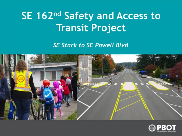
SE 162 nd Safety and Access to Transit Project SE Stark to SE Powell Blvd Where on 162nd? South of the STARK STREET Stark Street intersection - the Stark Street 162 ND AV intersection and 1.7 the area north miles of Stark Street is
Where on 162nd?
South of the Stark Street intersection - the Stark Street intersection and the area north
- f Stark Street is
part of the City
- f Gresham.
This project will not be changing the Stark Street intersection.
1.7 miles
STARK STREET DIVISION STREET 162ND AV
Why a crossing safety project on SE 162nd?
Traffic crashes are
- preventable. No one should
die or be incapacitated in the everyday act of getting where they need to go. The goal of Vision Zero is to eliminate fatal and serious injury crashes involving people walking, biking and driving.
Vision Zero goals
Why a crossing safety project on SE 162nd?
- 1. Portland streets are disproportionately dangerous for people
walking.
- 2. 23 of the 34 of the deadly crashes in 2018 were east of 82nd
Avenue.
- 3. Speed is a factor in 47% of fatal crashes. Higher speeds mean
more risk and greater damage when people are distracted, drive impaired, or simply make mistakes.
City-wide statistics
The posted speed is 35 miles per hour
- But as many as 80% of people are driving over the
posted limit!
- As many as 17% of people are driving 45 mph or
more!
- City and national data shows that higher speeds mean more
risk and greater damage when people are distracted, drive impaired, or simply make mistakes.
162nd Speed Data (2019) Why a crossing safety project on SE 162nd?
- 11 people injured while walking
- 5 people injured while biking
- 8 people seriously injured in a
vehicle
- 1 person died in a vehicle
Crash History on SE 162nd Alder to Powell 2007-2016 Why a crossing safety project on SE 162nd?
2019 data SHERMAN STREET 39-44 mph 5517 cars a day 45-50 mph 812 cars a day 51+ mph 148 cars a day 2019 data TAYLOR STREET 39-44 mph 2269 cars a day 45-50 mph 209 cars a day 51+ mph 32 cars a day 2019 data TAGGART STREET 39-44 mph 4397 cars a day 45-50 mph 1666 cars a day 51+ mph 454 cars a day
162nd Car Speed Data High end speeds!
What do those numbers really feel like and look like to the neighborhood? That looks like hundreds of people speeding on this street every day. Hundreds
- f people going 10 miles
- ver the speed limit or
more. City and national data show that slower driving speeds help prevent crashes, and when crashes occur, reduce the harm that results.
About 6,500 cars speeding each day
- 18,300 cars per day on 162nd Street north of Division Street
- 10,000 cars per day on 162nd Street south of Division Street
- Highest hourly volume by direction
- Northbound - 740 cars AM peak hour (at 162nd Street and
Market Street )
- Southbound - 910 cars PM peak hour (162nd Street and Taylor
Street)
162nd Car Speed and Volume Data (2019) Why a crossing safety project on SE 162nd?
For comparison – the highest recent count on Division Street = 35,700 cars per day. The north end of 162nd Street gets half the number of cars each day as Division
- Street. The south end of 162nd gets one third of the cars as Division Street.
There are fewer cars on 162nd Street south of Division Street. This makes sense with what we know about the high rates of speeding from the last slide. There’s so much unused space on the road that it’s encouraging faster speeds.
- High speeds!
- Street is 76 feet wide! Takes over 20 seconds to
walk across
- The 6,500 cars going over 40 mph each day + the
sprint across 5 lanes of traffic make this a dangerous street to cross
SE 162nd Stark to Powell Challenges Why a crossing safety project on SE 162nd?
Bus stop at Mill
TriMet Bus Line 74
- Launched line 74 in
2018
- Expanded service in
September 2019
- More buses during
peak commuting times
- Later trips
- Weekend service
Why a crossing safety project on SE 162nd?
Project area
TriMet Area Network Map
- Build safer crossings near
transit stops
- Increase safety through street
design and reduce speeding
- Improve existing bicycle lanes
About the project Project Goals
About the project: Project Elements
- Convert 5 lane road way to 3 lane by removing the
current striping and painting new striping
- New safer crossings with lighting at Mill, Lincoln
and Tibbets
- New sidewalk on Main west of 162nd and 162nd
north of Taylor
- Buffered bike lanes
About the project Project Elements
- Convert 5 lane road way to 3 lane by removing the
current striping and painting new striping
- This design reduces high end speeding
- Wide buffered bike lanes – more comfortable to ride
About the project Project Elements
Modeling of Travel Time Impacts
Existing 162nd (two lanes in each direction + center turn lane) Reorganized 162nd (1 lane in each direction plus a center turn lane) Southbound peak hour travel time SE Alder (just south of Stark) to SE Rhone (just north of Powell) 3 minutes 4 minutes and 8 seconds Northbound peak hour travel time SE Alder to SE Rhone 2 minutes 55 seconds 3 minutes and 32 seconds
68 additional seconds of travel driving from Stark Street to Powell Blvd
About the project: Project Elements New crossings with lights at Mill Street, Lincoln Street and Tibbets Street
At Tibbets Street, the speeds are slower, there’s lighting, there’s a shorter distance to cross exposed to cars.
About the project: Project Elements New crossings with lights at Mill Street, Lincoln Street and Tibbets Street
At Lincoln Street, the speeds are slower, there’s lighting, there’s a shorter distance to cross exposed to cars.
About the project: Project Elements New crossings with lights at Mill Street, Lincoln Street and Tibbets Street
At Mill Street, which has the highest ridership, the plan includes a island bus stop design which speeds up the bus and cuts down on waiting time when you’re riding the bus. Our budget is only large enough to do this design at one location.
Project Recommendation
53 lanes: Why ?
- Reduce fatal and serious crashes
- Reduce top-end speeding and average speeds
- Make pedestrian crossings safer
- Provide room for better bike & bus lanes
- Right-size roads to actual travel demand
- Create safe crossings at more locations for
- ur budget
68 additional seconds of travel driving from Stark to Powell in peak hour
What we heard and where we heard it
- Many parents and educators: envision a SE 162nd
Avenue that is more comfortable for pedestrians and people biking
- People with physical disabilities: challenges crossing
the street
- People are concerned about the road reorganization’s
impact on vehicle travel times.
- Some don’t feel that SE 162nd Avenue is unsafe.
What we heard and where we heard it
- In early April 2019: mailed both a project newsletter
and open house invitation to 10,000 homes and businesses in the project area.
- Held a community Open House in late April to receive
feedback about the proposed changes.
- Attended events at area schools and Rosewood Night
Out
- Connected with people via the feedback form on the
project’s website, email, and phone calls.
Principal Marin, Powell Butte Elementary School STEM night event “Student safety is always our number one priority. Many of our Powell Butte Students use 162nd
- n a daily basis. Any project that
increases our student's safety is important for our school community.”
What we heard and where we heard it
Lynchview Park
Two incredible parks are coming to this neighborhood that will attract kids from both sides
- f 162nd Ave.