radar observation of intense rain events during the
play

RADAR OBSERVATION OF INTENSE RAIN EVENTS DURING THE BOLLENE 2002 - PDF document

Sixth International Symposium on Hydrological Applications of Weather Radar RADAR OBSERVATION OF INTENSE RAIN EVENTS DURING THE BOLLENE 2002 EXPERIMENT John Nicol 1 , Guy Delrieu 1 , Dominique Faure 2 and Pierre Tabary 3 1 L.T.H.E., Grenoble,


  1. Sixth International Symposium on Hydrological Applications of Weather Radar RADAR OBSERVATION OF INTENSE RAIN EVENTS DURING THE BOLLENE 2002 EXPERIMENT John Nicol 1 , Guy Delrieu 1 , Dominique Faure 2 and Pierre Tabary 3 1 L.T.H.E., Grenoble, France : nicol@hmg.inpg.fr 2 Alicime, Lyon, France 3 Météo France, Paris, France Abstract 
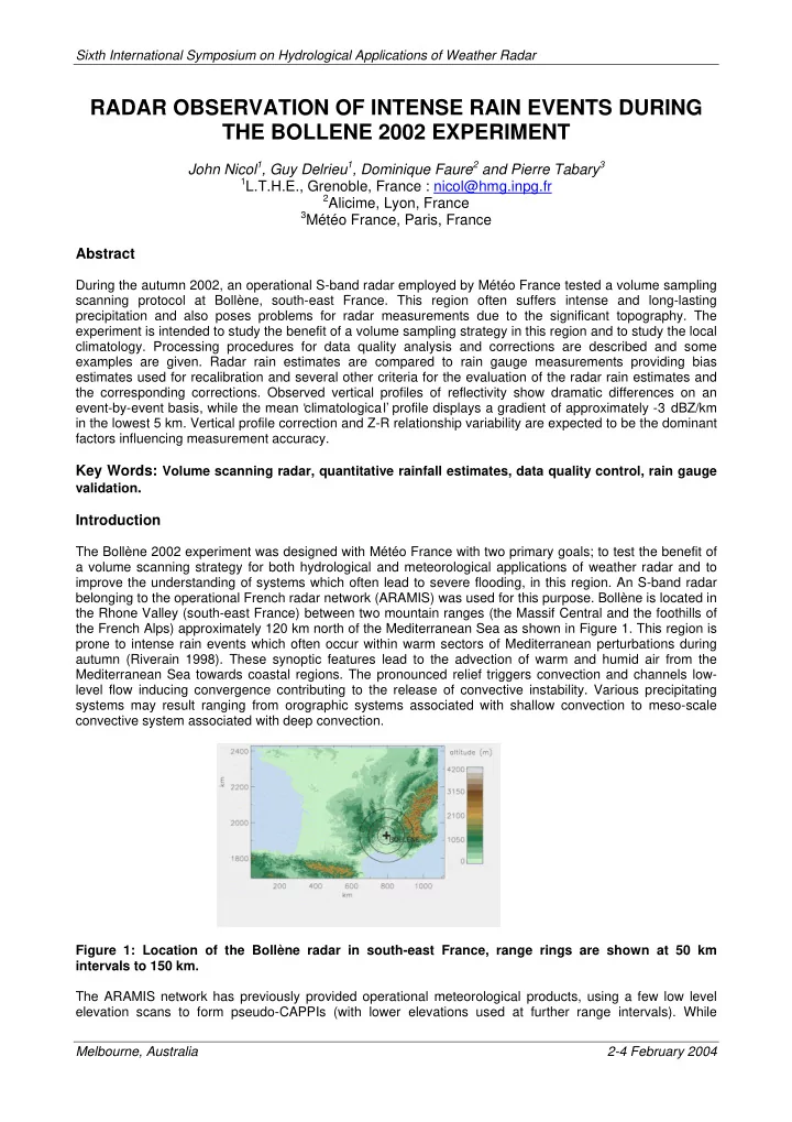
During the autumn 2002, an operational S-band radar employed by Météo France tested a volume sampling scanning protocol at Bollène, south-east France. This region often suffers intense and long-lasting precipitation and also poses problems for radar measurements due to the significant topography. The experiment is intended to study the benefit of a volume sampling strategy in this region and to study the local climatology. Processing procedures for data quality analysis and corrections are described and some examples are given. Radar rain estimates are compared to rain gauge measurements providing bias estimates used for recalibration and several other criteria for the evaluation of the radar rain estimates and the corresponding corrections. Observed vertical profiles of reflectivity show dramatic differences on an event-by-event basis, while the mean ‘climatological’ profile displays a gradient of approximately -3 dBZ/km in the lowest 5 km. Vertical profile correction and Z-R relationship variability are expected to be the dominant factors influencing measurement accuracy. Key Words: Volume scanning radar, quantitative rainfall estimates, data quality control, rain gauge validation . Introduction The Bollène 2002 experiment was designed with Météo France with two primary goals; to test the benefit of a volume scanning strategy for both hydrological and meteorological applications of weather radar and to improve the understanding of systems which often lead to severe flooding, in this region. An S-band radar belonging to the operational French radar network (ARAMIS) was used for this purpose. Bollène is located in the Rhone Valley (south-east France) between two mountain ranges (the Massif Central and the foothills of the French Alps) approximately 120 km north of the Mediterranean Sea as shown in Figure 1. This region is prone to intense rain events which often occur within warm sectors of Mediterranean perturbations during autumn (Riverain 1998). These synoptic features lead to the advection of warm and humid air from the Mediterranean Sea towards coastal regions. The pronounced relief triggers convection and channels low- level flow inducing convergence contributing to the release of convective instability. Various precipitating systems may result ranging from orographic systems associated with shallow convection to meso-scale convective system associated with deep convection. Figure 1: Location of the Bollène radar in south-east France, range rings are shown at 50 km intervals to 150 km. The ARAMIS network has previously provided operational meteorological products, using a few low level elevation scans to form pseudo-CAPPIs (with lower elevations used at further range intervals). While Melbourne, Australia 2-4 February 2004

  2. Sixth International Symposium on Hydrological Applications of Weather Radar necessitating faster scans rates to obtain similar temporal resolution, a volume scanning protocol allows many advantages with respect to data quality. A dense network of rain gauges (365 gauges, ~1/100 km²) cover the chosen research region (the Cevénnes-Vivarais) as shown in Figure 2 and are used for calibration and evaluation purposes. Both ‘static’ and ‘dynamic ’ data processing are developed for the estimation of rain rate fields at ground level with a view to the evaluation of the relative ability of the corrections. ‘Static’ approaches use ‘information a priori’ products such as dry weather ground clutter maps and climatological vertical profiles of reflectivity (VPR). ‘Dynamic’ approach uses adaptive treatments, utilising data on a scan- by-scan basis. These include; the identification of ground clutter areas using a combination of a variability criterion derived from the inter-pulse radar signal and of horizontal reflectivity gradients, and the use of ground clutter targets of high intensity and low variability (low SIGMA, hence clutter) to analyse radar calibration stability. The processing is based on a modular approach allowing the inclusion of various correction procedures to evaluate the relative improvement in terms of rainfall estimation. Figure 2: The topography of the Cevénnes-Vivarais region, showing the radar at Bollène and the sites of the 365 rain gauges (triangles) and the neighbouring radar at Nimês. The rain gauge accumulations are used to create 2D rain and error estimates using interpolation based on kriegage. Selected parts of rain fields derived from the radar and gauge network measurements are then compared for calculating biases in the accumulations and other similarity criteria. Only regions with low estimated standard deviation (eg normalised std. dev. < 40%) in the kreiged-rain gauge field and which are also outside regions of affected by ground clutter and beam shielding are used in the comparison. The analyses presently consider daily and event-long gauge accumulations. This will be complimented by hourly comparisons for which 170 gauges exist in the study region. Future work will focus on the correction of the vertical profile of reflectivity (VPR) and its association with Z-R relationships and drop size distributions. Bollène 2002 experiment Operating protocol and data set Between September and December 2002, the radar at Bollène was operated with an “interlaced” volume scanning strategy: 8 PPIs were performed every 5 min. with antenna rotation speeds of 10°/s (low elevation angles) and 15°/s (higher elevation angles). 3 PPIs at elevation angles of 0.8°, 1.2° and 1.8° were repeated every 5 min. to provide the pre-existing operational products. Two sets of additional angles (0.4°, 3.6°, 6.0°, 9.0°, 14.0° and 2.4°, 4.8°, 7.3°, 11.1°, 18.0°) were alternated every 5 min. in order to optimise the volume sampling of atmosphere. Hence, a ‘complete’ volume scan was accomplished every 10 min. Both the average reflectivity (Z, stored as dBZ)) and the inter-pulse variability (SIGMA) are archived for each PPI with a spatial resolution of 1 km². SIGMA, which is the absolute difference in reflectivity (dBZ) between each second pulse, averaged over the Cartesian grid, is used as part of a ground clutter identification procedure both for the elimination and the identification of non-raining regions of intense clutter for calibration stability analysis. The autumn 2002 had about 21 rainy days in the Cevénnes-Vivarais region, of these several Melbourne, Australia 2-4 February 2004

  3. Sixth International Symposium on Hydrological Applications of Weather Radar produced significant accumulations near the Bollène radar, allowing accurate comparisons. The radar worked well with the new operating protocol during this period, providing a unique data set including the catastrophic 8-9th Sept. event in the Gard region in which rain accumulations over 600 mm were recorded in 24 hours by both radar and rain gauges. Radar processing strategies and validation The final objective of this project is to define optimal processing strategies to obtain both temporal 2D (ground level rain amounts) and eventually 3D (water content) hydro-meteorological products to be used for the forcing and/or validation of meteorological and hydrological models. Naturally, quality control is critical in any analysis and the current work is ongoing. A number of preliminary studies have and are being conducted on the following subjects; Ground clutter identification, beam shielding correction, vertical profile of reflectivity measurement and correction, precipitation type classification and calibration analysis. Some examples are given in the following sections. Ground clutter The ground clutter identification scheme uses a combination of the mean inter-pulse variability on a scan-by- scan basis and neighbouring horizontal reflectivity gradients. The product SIGMA for the Bollène radar is a 1x1 km² average of the absolute difference in terms of dBZ for pulses at equal range separated by two pulses or 8 ms. This has been shown, when incorporated with a threshold on neighbouring maximum local gradients, to be an efficient method of ground clutter identification for incoherent radar. For the example given, the parameterisation eliminates all pixels with mean values of SIGMA < 3.5 dB and all surrounding pixels with maximum absolute horizontal gradients > 8 dBZ/km (relative to their eight closest pixels). This approach allows the identification of regions of anomalous propagation and has been shown to remove over 99% of regular ground clutter in dry conditions, while affecting less than 2% of precipitation measurements (Nicol et al., 2003). Figure 3: PPIs at 0.8° with clutter-processed data (left) and raw data (right) shown for a dry weather example (upper) and an example in precipitation (lower). The range rings correspond to 50 km. Melbourne, Australia 2-4 February 2004

Download Presentation
Download Policy: The content available on the website is offered to you 'AS IS' for your personal information and use only. It cannot be commercialized, licensed, or distributed on other websites without prior consent from the author. To download a presentation, simply click this link. If you encounter any difficulties during the download process, it's possible that the publisher has removed the file from their server.

Recommend


More recommend