
SLIDE 1
Laboratoire de systèmes d’information géographique LaSIG
An open monoplotter to register landscape oblique images and generate their synthetic model.
26-Oct-12 OGRS 2012, Yverdon-les-Bains, Produit T. 1
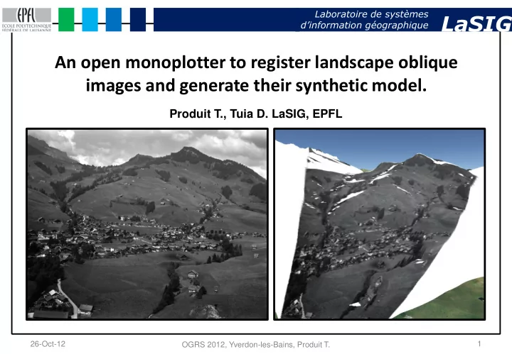
Produit T., Tuia D. LaSIG, EPFL 26-Oct-12 1 OGRS 2012, - - PowerPoint PPT Presentation
Laboratoire de systmes dinformation gographique LaSIG An open monoplotter to register landscape oblique images and generate their synthetic model. Produit T., Tuia D. LaSIG, EPFL 26-Oct-12 1 OGRS 2012, Yverdon-les-Bains, Produit T.
Laboratoire de systèmes d’information géographique LaSIG
26-Oct-12 OGRS 2012, Yverdon-les-Bains, Produit T. 1
Laboratoire de systèmes d’information géographique LaSIG
26-Oct-12 OGRS 2012, Yverdon-les-Bains, Produit T. 2
Laboratoire de systèmes d’information géographique LaSIG
26-Oct-12 OGRS 2012, Yverdon-les-Bains, Produit T. 3
Laboratoire de systèmes d’information géographique LaSIG
26-Oct-12 OGRS 2012, Yverdon-les-Bains, Produit T. 4
Laboratoire de systèmes d’information géographique LaSIG
26-Oct-12 OGRS 2012, Yverdon-les-Bains, Produit T. 5
Laboratoire de systèmes d’information géographique LaSIG
26-Oct-12 OGRS 2012, Yverdon-les-Bains, Produit T. 6
Laboratoire de systèmes d’information géographique LaSIG
26-Oct-12 OGRS 2012, Yverdon-les-Bains, Produit T. 7
Laboratoire de systèmes d’information géographique LaSIG
26-Oct-12 OGRS 2012, Yverdon-les-Bains, Produit T. 8
Laboratoire de systèmes d’information géographique LaSIG
26-Oct-12 OGRS 2012, Yverdon-les-Bains, Produit T. 9
Library of Congress, View of Switzerland , ~1890-1900, http://www.loc.gov/pictures/
Laboratoire de systèmes d’information géographique LaSIG
26-Oct-12 OGRS 2012, Yverdon-les-Bains, Produit T. 10
Laboratoire de systèmes d’information géographique LaSIG
26-Oct-12 OGRS 2012, Yverdon-les-Bains, Produit T. 11
Laboratoire de systèmes d’information géographique LaSIG
26-Oct-12 OGRS 2012, Yverdon-les-Bains, Produit T. 12
Laboratoire de systèmes d’information géographique LaSIG
26-Oct-12 OGRS 2012, Yverdon-les-Bains, Produit T. 13
Acm – EPFL, fonds Perrochet – Pleinciel SA , ~1960.
Laboratoire de systèmes d’information géographique LaSIG
26-Oct-12 OGRS 2012, Yverdon-les-Bains, Produit T. 14
Laboratoire de systèmes d’information géographique LaSIG
26-Oct-12 OGRS 2012, Yverdon-les-Bains, Produit T. 15
SURF features SURF matching
Laboratoire de systèmes d’information géographique LaSIG
26-Oct-12 OGRS 2012, Yverdon-les-Bains, Produit T. 16
SURF matching RANSAC computation Visual quality assessment
Laboratoire de systèmes d’information géographique LaSIG
26-Oct-12 OGRS 2012, Yverdon-les-Bains, Produit T. 17
EFLUM – EPFL, 2012.
Laboratoire de systèmes d’information géographique LaSIG
26-Oct-12 OGRS 2012, Yverdon-les-Bains, Produit T. 18