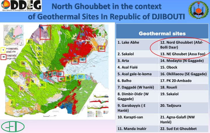
of geothermal sites in republic of djibouti
play

of Geothermal Sites In Republic of DJIBOUTI Geother Geothermal mal - PowerPoint PPT Presentation

North Ghoubbet in the context of Geothermal Sites In Republic of DJIBOUTI Geother Geothermal mal sites sites 1. Lake Abhe 12. Nord Ghoubbet (Afa- Bolli Daar) 2. Sakalol 13. NE Ghoubet (Assa Foo) 3. Arta 14. Modayto (N Gaggade) 4. Asal


  1. North Ghoubbet in the context of Geothermal Sites In Republic of DJIBOUTI Geother Geothermal mal sites sites 1. Lake Abhe 12. Nord Ghoubbet (Afaî- Bolli Daar) 2. Sakalol 13. NE Ghoubet (Assa Foo) 3. Arta 14. Modayto (N Gaggade) 4. Asal Fialé 15. Obock 5. Asal gale-le-koma 16. Okililaeou (SE Gaggade) 6. Balho 17. PK 20-Ambado 7. Daggadé (W hanlé) 18. Roueli 8. Dimbir-Didir (W 19. Sakalol Gaggade) 9. Garabayyis ( E 20. Tadjoura Hanlé) 10. Karapti-san 21. Agna-Galafi (NW Hanlé) 11. Manda Inakir 22. Sud Est Ghoubbet

  2. North Ghoubbet Geothermal site 11 °35’18 N ; 42 °35’13 E • Good access with two tracks allowing to reach S part the site; numerous hydrothermal manifestations, Access: 2h from Djibouti; 1h from Tadjourah past (fossil silica deposits) and present (fumaroles and hydrothermal alteration and deposits (RN9)

  3. North-Ghoubbet Geographic context No electric line at present but 320 kVA DEM (rose : 0-300m, blue : 300-600m, green : 600-900m, foreseen by EDD linking Djibouti to Tadjourah yellow 900-1200m, brown 1200-1500m

  4. • DEM picture and geological context

  5. North Ghoubbet geological context Geological map of N Ghoubbet showing the location of major fumaroles and hot-springs (orange circles) identified (from geological map of Tadjourah, 1/100.000 scale)

  6. North Ghoubbet Geological, hydrogeological and geophysical context: • The basalts of the Ghoubbet series, emitted along the axis of the proto-rift between 2 an 1 My ago are coverning in discordance the basalts of the Dalha series (8 to 4My), which are intensively faulted, tilted and eroded, as well as the alluvial detrital series resulting from the surrection and erosion of Mt. Goda. • Numerous fumaroles, hot grounds and hydrothermal alteration and deposits are observed along NNW-SSE and NW-SE faults and open fissures affecteing the basalts of the Ghoubbet series. • More recent basalts occur along the Gulf shore, coverning in discordance the previously faulted basalts of the Gulf showing a continuous process of accretion. • Thermal manifestations are equally zoned. Gas geothermometres indicate temperatures of 228-323°C.

  7. • Geodynamic context showing the rotation of the N-Ghoubbet block (Manighetti et al. 2001) on a regional relief map. • Deformations measured from radar satellite images interferometry over a 10 year period (1997-2008). The most intense deformations in red and violet reach 30 mm/y in the N-Ghoubbet block (Doubre et al. 2012)

  8. North Ghoubbet; an attractive geological context in the Republic of Djibouti • Nothern side of Ghoubbet active oceanic rift (normal faults with SW throw) • Very faulted area due to normal and transform faulting NNW- SSE & WNW-ESE • Rotating block under intense deformation • Intense and active erosion for the last 4Ma at the foot of rising Mt. Goda (1799m) • One of the only site in Djibouti fed by fresh meteoritic water • Good geothermal reservoir conditions (formation + faulting) • Good heat source (vicinity of the assymetric active ridge)

  9. North Ghoubbet geophysical survey Map of the gravimetric anomalies (in milligals) obtained by Puvilland et al. (BRGM, 1993). Yellow dots indicate the location of fumaroles MT sites measurements by CERD (2011) are shown as green triangles

  10. Nothe Ghoubbet conceptual geothermal model • Heat source: Ghoubbet active oceanic ridge located in the immediate vicinity (a few 100m) from the shore, with a well identified shield volcano along the axis. • Reservoir: Dalha basalts and detrital fromations intensively faulted (230-320°C) • Cover; recent basalts and hyaloclastites and clay alteration zones • Low salinity expected (meteoritic and sea water) • Conductive layers identified, to be mapped more precisely (reservoir cover)

  11. Conceptual model North Ghoubbet Coupe schématique du modèle de gisement géothermique de Nord Ghoubbet : les basaltes du Dalha (8 à 4 Ma), qui recouvrent les rhyolites des Mabla faillées et érodées, sont soulevés et intensément faillés à l’approche du Ghoubbet. Ils sont érodés et les alluvions grossiers sont intercalés dans les basaltes initiaux du golfe de Tadjourah et du Ghoubbet (moins de 1Ma). L’ensemble est à nouveau intensément faillé lors de la formation du Ghoubbet et du fait de l’activité du rift du Ghoubbet et de la zone transformante qui fait le relais avec le rift de Tadjourah. Source de chaleur magmatique et mantellique et circulation des fluides (eau météoritique et eau de mer) alimentant le réservoir géothermique

  12. North Ghoubbet perspectives • Exploration works : géologie structurale (1975-2000), hydrogéochimie (1983, 1987, 1992), géophysique : gravimétrie et AMT/TDEM and MT (1983, 2011), géologie ODDEG (en cours). • Easy access by tracks from the asphalted road (RN9) • Near to Fiale and Gale le Koma sites Perspectives : a geothermal site of major interest that could show a large extension (connection E-W along the Ghoubbet N shore and the ghoubbet pass) Remaining to be done : complementary geology, mineralogy and geochemistry, extension of the MT surveys, exploration drilling

  13. N Ghoubbet references AQUATER (1981). Projet pour l'évaluation des ressources géothermiques. ISERST .137p. AQUATER (1989) Geothermal exploration project. Republic of Djibouti. Final Report. ISERST. 159p Barberi F., Ferrara G., Santacroce R. and Varet J. (1975) Structural evolution of th Afar triple junction. Afar Depression of Ethiopia, Bad Bergzarben, Germany, April 1-6 1974. A. Pilger and A. Rösler1 38-54. Barberi F. & Varet J. (1977) Volcanism of Afar: small scale plate tectonics implication. Bull. Géo. Soc. Amer. 881251-1266. CERD (2011) Etude de préfaisabilité du prospect Nord Ghoubbet, République de Djibouti. Rapport final, 58p. Correia, H., Demange, J., Fabriol, R., Gérard, A., Varet, J. (1983) Champ géothermique d’Asal . Synthèse des données disponibles au 1er janvier 1983. BRGM/83-SGN-022-GTH 71p., 10 cartes. Gadalia, A., Iundt, F., Fabriol, R. (1982) Géothermie – République de Djibouti. Exploration géologique et géochimique de la zone Nord-Ghoubat. BRGM/82-SGN-022-GTH 21p. 5 cartes. Dauteuil, O., Huchon, P., Quemeneur, F., Souriot, T. (2001) Propagation of an oblique spreading centre : the west Gulf of Aden. Tectonophysics , 332, 423-442. Houmed, A.M., Haga, A.O., Abdillahi, S.O., Varet, J. (2012) Nord-Ghoubbet geothermal site, Djibouti Republic. Proc. 4 th Afric. Rift Conf. Nairobi, Kenya , 7p. Jalludin M. (2003) An overview of the geothermal prospections in the Republic of Djibouti. Results and perspectives. Kengen geothermal conference, Nairobi. Manighetti, I., Tapponnier, P., Gillot, Y., Jacques, E., Courtillot, V., Armijo, R.,Ruegg, J.C. & King, G. (1998) Propagation of rifting along the Arabia- Somalia plate boundary Into Afar. J . Geoph. Res. 103 p.4947-4974 Manighetti, I., P. Tapponnier,V. Courtillot,Y. Gallet, E. Jacques, & Y. Gillot (2001) Strain transfer between disconnected, propagating rifts in Afar, J. Geophys. Res .,106 13,613 – 13,665. Marinelli G. et Varet J. (1973) Structure et évolution du Sud du ”horst Danakil” (TFAI et Ethiopie). C.R. Acad. Sci. Paris , D 276 1119-1122. Puvilland, P., Benderitter, Y., Charboneyre, P., Dore, P., Lesage, P., Madelaine, B., (1983) Reconnaisssance géothermique par prospection gravimetrique et électrique audiomagnetotellurique dans la région du Nord-Ghobbat (République de Djibouti). BRM/83-SGN-932-GTH 54p., 6 cartes Richard, O. & Varet, J. (1979) Study of the transition from a deep oceanic to emerged rift zone: Gulf of Tadjoura, République de Djibouti. Int. Symp. Geodyn. Evols. Afro-Arabian System, Roma Sanjuan B., Michard G. et Michard A. (1990) Origine des substances dissoutes dans les eaux des sources thermales et des forages de la région Asal-Goubhet (République de Djibouti). J. Volcanol. & Geothermal Res , 43 333-352 Varet J. (1975) Carte géologique de l’Afar central et méridional, CNR-CNRS, 1/500 000 Géotechnip Varet J. (2010) Contribution to favourable geothermal site selection in the Afar triangle, Argeo Meeting, Djibouti , 17p.

Download Presentation
Download Policy: The content available on the website is offered to you 'AS IS' for your personal information and use only. It cannot be commercialized, licensed, or distributed on other websites without prior consent from the author. To download a presentation, simply click this link. If you encounter any difficulties during the download process, it's possible that the publisher has removed the file from their server.

Recommend


More recommend