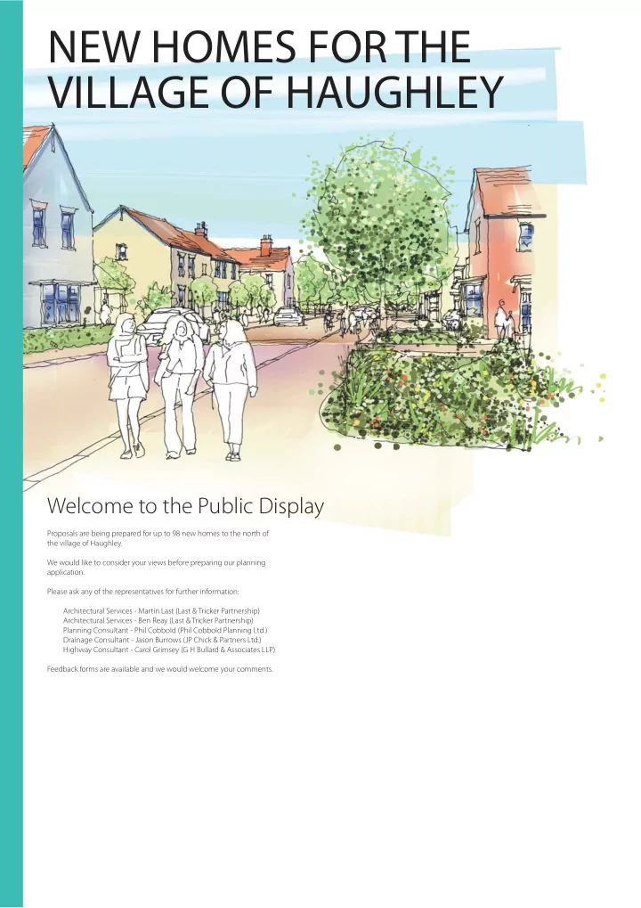
new homes for the village of haughley
play

NEW HOMES FOR THE VILLAGE OF HAUGHLEY Welcome to the Public Display - PDF document

NEW HOMES FOR THE VILLAGE OF HAUGHLEY Welcome to the Public Display Proposals are being prepared for up to 98 new homes to the north of the village of Haughley. We would like to consider your views before preparing our planning application.


  1. NEW HOMES FOR THE VILLAGE OF HAUGHLEY Welcome to the Public Display Proposals are being prepared for up to 98 new homes to the north of the village of Haughley. We would like to consider your views before preparing our planning application. Please ask any of the representatives for further information: Architectural Services - Martin Last (Last & Tricker Partnership) Architectural Services - Ben Reay (Last & Tricker Partnership) Planning Consultant - Phil Cobbold (Phil Cobbold Planning Ltd.) Drainage Consultant - Jason Burrows (JP Chick & Partners Ltd.) Highway Consultant - Carol Grimsey (G H Bullard & Associates LLP) Feedback forms are available and we would welcome your comments.

  2. SITE LOCATION The Site The proposed site is 4.28 hectares (10.58 acres) in area and lies to the east of King George’s Playing Field. Haughley is located 2.5 miles to the north of the town of Stowmarket, within the district SITE of Mid-Su fg olk Council. The parish has a population in excess of 1600 people. HAUGHLEY A14 NORTH Education Crawford’s Primary School is situated to the west of the site on Green Road and within easy walking distance from the new dwellings indicated. Plot nos. 95-98, ie: the dwellings furthest from the school are just 500m walk away. Latest Su ff olk County Council figures (published Autumn 2016) indicate that the school currently has su ffi cient capacity for the additional pupils likely to be generated by this development. SCC have also confirmed that Thurston, Stowupland and Stowmarket secondary schools currently have capacity. Village Amenity Amenity provision in Haughley includes a Co-op store together with the village hall, the post o ffi ce, the Kings Arms PH, bakery, restaurant, and hairdressers. Again, the Looking South on to the site from Bacton Road connectivity of the site to the village via new and existing footpaths linked to Church View is ideal for walking and cycling. The dwellings indicated on plot nos. 95-98 are just 800m from the Co-op and 600m from the Kings Arms PH. Recreation The site lies immediately to the East of King George’s Field and it is proposed that Crawford’s CEVC Primary School, Green Road Play area to the south of King George’s Field footpaths within the development will link to those which exist around the playing field. King George’s Field is home to Haughley Utd Football Club, Haughley P. F. Bowls Club and has a well-equipped children’s play area. The Ron Crascall Pavilion is at the northern end of the playing field. The development proposes a new under-10’s 7-a-side football pitch which will also act as a bu ff er between existing housing to the south and the new development whilst also linking the development to the sports facilities. Old Street, Haughley - looking south Ron Crascall Pavilion, King George’s Playing Field A ff ordable housing There will be a significant percentage of a ff ordable housing included within the develoment. Subject to agreement tenures will include: - A ff ordable rent - Shared ownership - Discounted market value dwellings COOP supermarket - Old Street, Haughley The Post O ffi ce - The Green, Haughley

  3. SITE CONTEXT 1 Existing footway 2 King George’s Playing Field 3 Haughley P. F. Bowls Club Green Road 4 Ron Crascall Pavilion 5 Crawford’s CEVC Primary School 6 Church 7 The King’s Arms PH 8 Post O ffi ce P u b l i c 9 Bakery f o o t p a t h 10 Village Hall 3 11 Supermarket (COOP) 4 12 Agricultural fields Bus stops Green Road Public footpath Boundary with existing SITE playing fields 2 Boundary with existing residential area 1 Proposed location of vehicular access 12 5 Duke Street 1 6 7 8 NORTH Castle Rise O y a 9 l d W C h u S r c e h t V r g i e 10 e w n e The Folley i t a r G 11 Flood Risk Utilities The proposed development will be safe from Enquiries have been made to utility providers. There is an AW foul water flooding and will not increase flood risk to third sewer on the site. The development will be designed to ensure the parties. The site lies in ‘Flood Zone 1’ (Low required utility easements are provided in accordance with industry Probability of river or sea flooding). guidelines. Overhead electricity cables will be diverted and relocated underground. Ecology Surface water An ecological assessment has been undertaken on the site. The Surface water drainage from roofs, roads and hard proposed development site was considered low in ecological value. The surfaces will be based on Sustainable Drainage areas of highest ecological value, the hedgerows and trees on the Systems (SUDS). This will be developed as part of boundary will be retained the planning application to include a guarded on-site attenuation pond, which will be of amenity The proposed landscape strategy will incorporate native species of tree and ecological benefit. The pond will discharge to and wild flower planting ensuring the continuity of habitats for wildlife the existing ditch to the south of the site. within the site. Bird and bat boxes will be built into the development as required by the ecological consultant. Tra ffi c Vegetation A new access is proposed o ff Green Road. The proposed junction will be The site is currently overgrown with wild oats. constructed in accordance with the design standards of SCC. The siting Existing trees and hedges are restricted to the of the access and required visibility splays has been derived from western, southern and eastern boundaries of the speed/tra ffi c surveys carried out by Highway Consultants. The 30mph site. Existing vegetation will be retained and speed restriction will be extended if required by SCC. enhanced. Small breaks will be formed to allow pedestrian access. Contact has been made with Su ff olk County Council with regard to public transport. They have suggested a contribution of £5,000 for im- The development will include new planting of provements to the bus stop infrastructure. The Su ff olk County Council native species of trees and hedgerows common to Passenger Transport Operations Manager acknowledges that most bus the Su ff olk countryside. journeys on the existing route would be able to cope with the addition- al demand created by the development.

Download Presentation
Download Policy: The content available on the website is offered to you 'AS IS' for your personal information and use only. It cannot be commercialized, licensed, or distributed on other websites without prior consent from the author. To download a presentation, simply click this link. If you encounter any difficulties during the download process, it's possible that the publisher has removed the file from their server.

Recommend


More recommend