SLIDE 1
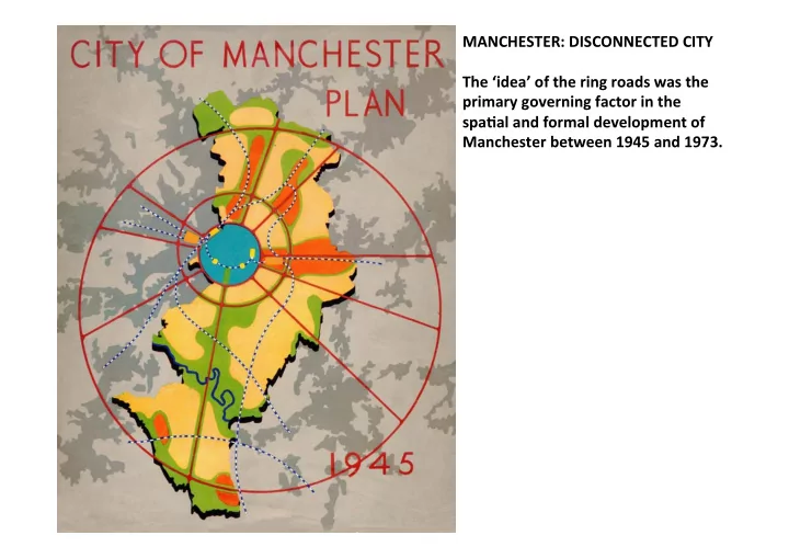
MANCHESTER: ¡DISCONNECTED ¡CITY ¡ ¡ The ¡‘idea’ ¡of ¡the ¡ring ¡roads ¡was ¡the ¡ primary ¡governing ¡factor ¡in ¡the ¡ spaDal ¡and ¡formal ¡development ¡of ¡ Manchester ¡between ¡1945 ¡and ¡1973. ¡ ¡
SLIDE 2
SuggesDon ¡of ¡ring-‑roads ¡around ¡Manchester. ¡Anonymous, ¡1928. ¡ ¡
SLIDE 3 Proposal ¡for ¡city ¡centre ¡ring-‑road ¡in ¡Manchester. ¡City ¡Surveyor, ¡1932. ¡ ¡ ‘…the ¡Region ¡is ¡very ¡badly ¡ provided ¡for ¡in ¡the ¡ma7er ¡of ¡ circumferen:al ¡roads’ ¡ ¡ Manchester ¡and ¡District ¡Joint ¡ Town ¡Planning ¡Advisory ¡
- Commi7ee. ¡Report ¡Upon ¡The ¡
Regional ¡Scheme, ¡1926. ¡ ¡ ¡ ¡ ¡
SLIDE 4 City ¡of ¡Manchester ¡Plan ¡1945. ¡ ¡ Plate ¡21 ¡ ¡
- City ¡Centre ¡Road ¡
- Inner ¡Ring ¡Road ¡
- Link ¡Road ¡17/7 ¡
- Intermediate ¡Ring ¡Road ¡
- Outer ¡Ring ¡Road ¡
Rowland ¡Nicholas ¡
SLIDE 5 Extract ¡from: ¡Manchester ¡Regional ¡Plan ¡1945. ¡Proposed ¡Road ¡System ¡ ¡
- Link ¡Road ¡17/7 ¡is ¡not ¡shown ¡as ¡a ¡feature ¡here, ¡nor ¡is ¡the ¡City ¡Centre ¡Road. ¡
SLIDE 6
City ¡of ¡Manchester ¡Plan. ¡Central ¡Area ¡zoning. ¡1945. ¡ ¡
SLIDE 7
- 1945. ¡Map ¡drawn ¡by ¡M. ¡Jarvis ¡
SLIDE 8
City ¡of ¡Manchester ¡Plan. ¡Manchester ¡2045 ¡AD. ¡1945. ¡ ¡
SLIDE 9
City ¡Centre ¡plans, ¡revised ¡1948. ¡ ¡
SLIDE 10
Bomb ¡damage ¡maps. ¡Manchester. ¡ ¡
SLIDE 11
Area ¡between ¡Portland ¡Street ¡and ¡Mosley ¡Street, ¡late ¡1940s. ¡
SLIDE 12
Portland ¡Street ¡sketch, ¡late ¡1940s. ¡
SLIDE 13
Central ¡Area ¡Replanning. ¡Release ¡of ¡sites ¡in ¡relaDon ¡to ¡city ¡centre ¡road ¡route. ¡1947. ¡ ¡
SLIDE 14
Aerial ¡view ¡of ¡Cathedral ¡Area. ¡Longridge ¡House, ¡H.S. ¡Fairhurst ¡& ¡Sons, ¡1959. ¡
SLIDE 15
- 1961. ¡Map ¡drawn ¡by ¡M. ¡Jarvis ¡
SLIDE 16
Granada ¡TV. ¡Ralph ¡Tubbs. ¡1954-‑1966. ¡
SLIDE 17
Granada ¡main ¡building. ¡
SLIDE 18
Grenfell ¡Baines ¡and ¡Hargreaves. ¡Lower ¡Mosley ¡Street. ¡1960-‑61. ¡
SLIDE 19
Grenfell ¡Baines ¡and ¡Hargreaves. ¡Lower ¡Mosley ¡Street. ¡1960-‑61. ¡
SLIDE 20
Grenfell ¡Baines ¡and ¡Hargreaves. ¡Lower ¡Mosley ¡Street. ¡1960-‑61. ¡
SLIDE 21 Cover: ¡ S.E.L.N.E.C. ¡A ¡Highway ¡Plan. ¡1962 ¡ ¡ ¡
- City ¡Centre ¡Road ¡
- Inner ¡Ring ¡Road ¡
- Link ¡Road ¡17/7 ¡
- Intermediate ¡Ring ¡Road ¡
- Outer ¡Ring ¡Road ¡
SLIDE 22 Extract ¡from: ¡ S.E.L.N.E.C. ¡A ¡Highway ¡Plan. ¡1962 ¡ Overloading ¡Diagram ¡ ¡ ¡
- Almost ¡every ¡road ¡in ¡central ¡Manchester ¡is ¡
predicted ¡to ¡be ¡at ¡100-‑150% ¡or ¡over ¡150% ¡ capacity ¡by ¡1965. ¡
SLIDE 23 Extract ¡from: ¡ S.E.L.N.E.C. ¡A ¡Highway ¡Plan. ¡1962 ¡ Road ¡Network ¡Model ¡ ¡
- Each ¡junc:on ¡is ¡made ¡as ¡a ¡node ¡
in ¡the ¡networked ¡model ¡and ¡ assigned ¡a ¡number. ¡These ¡were ¡ traffic ¡survey ¡points. ¡
SLIDE 24 A ¡Phased ¡Programme ¡of ¡Roadworks ¡ in ¡the ¡SELNEC ¡Area. ¡1963. ¡ ¡
- M62 ¡as ¡sec:on ¡of ¡future ¡M60 ¡
- SW ¡sec:on ¡of ¡City ¡Centre ¡Road ¡
- Link ¡Road ¡17/7 ¡
- Intermediate ¡Ring ¡Road ¡
- Outer ¡Ring ¡Road ¡
SLIDE 25 Manchester ¡City ¡Centre ¡Road, ¡
¡
- Route ¡shown ¡to ¡cross ¡the ¡
Irwell ¡into ¡Salford ¡
- Car ¡parking ¡at ¡edges ¡of ¡
centre ¡is ¡posi:vely ¡drawn ¡in ¡ rela:on ¡to ¡ring ¡road ¡seZng ¡
- ut ¡
- Major ¡railway ¡proposals ¡no ¡
longer ¡indicated ¡
SLIDE 26
- 1967. ¡Map ¡drawn ¡by ¡M. ¡Jarvis ¡
SLIDE 27
Extract ¡from ¡Manchester ¡City ¡Centre ¡Map ¡showing ¡CDA ¡allocaDon, ¡1967. ¡ ¡
SLIDE 28
Model ¡of ¡City ¡Centre ¡that ¡was ¡on ¡display ¡in ¡Planning ¡Department ¡foyer. ¡
SLIDE 29
Car ¡park ¡provision. ¡Joint ¡report ¡on ¡car ¡parking ¡in ¡central ¡Manchester. ¡1967. ¡ ¡
SLIDE 30
Sketch ¡Plan ¡to ¡accompany ¡1968 ¡City ¡Centre ¡Road ¡study. ¡
SLIDE 31
City ¡Centre ¡Advisory ¡Schemes. ¡Mid-‑1960s. ¡ ¡
SLIDE 32
Entertainment ¡Centre ¡/ ¡Portland ¡Street ¡Area. ¡Model. ¡Mid-‑1960s. ¡
SLIDE 33
Bomb ¡damage ¡maps. ¡Portland ¡Street ¡area. ¡ ¡
SLIDE 34
Eagle ¡Star ¡House, ¡Mosley ¡Street. ¡ ¡ Cruickshank ¡and ¡Seward. ¡1973 ¡
SLIDE 35
Williams ¡Deacons ¡Bank, ¡Mosley ¡Street. ¡H.S. ¡Fairhurst ¡and ¡Sons. ¡1960. ¡
SLIDE 36
View ¡along ¡Portland ¡Street. ¡St. ¡Andrew’s ¡(Portland) ¡Tower. ¡Leach, ¡Rhodes ¡and ¡Walker, ¡1963. ¡ Telephone ¡House, ¡E. ¡Norman ¡Bailey ¡& ¡Partners, ¡1961. ¡
SLIDE 37
Ridgefield ¡House, ¡John ¡Dalton ¡Street. ¡Leach, ¡Rhodes ¡and ¡Walker. ¡1966. ¡ ¡
SLIDE 38
Leach, ¡Rhodes ¡and ¡Walker. ¡Highland ¡House. ¡1966. ¡ ¡
SLIDE 39
Cruickshank ¡and ¡Seward. ¡Lower ¡Mosley ¡Street. ¡1971/72. ¡ ¡
SLIDE 40
Cruickshank ¡and ¡Seward. ¡Lower ¡Mosley ¡Street. ¡1971/72. ¡ ¡ The ¡City ¡is ¡renewing ¡itself, ¡assuming ¡a ¡fresh ¡form, ¡and ¡in ¡doing ¡so ¡genera:ng ¡a ¡demand ¡for ¡ building ¡which ¡has ¡scarcely ¡been ¡equalled. ¡W.A. ¡Gibbon, ¡Cruickshank ¡and ¡Seward. ¡ ¡
Waterhouse, ¡R. ¡(1972) ¡‘Dis:nguished ¡Buildings ¡in ¡Central ¡Manchester’. ¡The ¡Guardian. ¡18th ¡July. ¡
SLIDE 41
DistribuDon ¡of ¡new ¡building ¡in ¡Manchester ¡in ¡relaDon ¡to ¡city ¡centre ¡road. ¡1963. ¡ ¡
SLIDE 42
Cruickshank ¡and ¡Seward. ¡Central ¡StaDon ¡redevelopment. ¡Early ¡1970s ¡
SLIDE 43
Leach, ¡Rhodes ¡and ¡Walker. ¡Lower ¡Mosley ¡Street. ¡1973. ¡ ¡
SLIDE 44
Leach, ¡Rhodes ¡and ¡Walker. ¡Lower ¡Mosley ¡Street. ¡1973. ¡ ¡
SLIDE 45
Leach, ¡Rhodes ¡and ¡Walker. ¡Portland ¡Towers. ¡Portland ¡Street/Princess ¡Street. ¡1973. ¡ ¡
SLIDE 46
Greater ¡Manchester ¡County ¡Structure ¡Plan ¡boundary. ¡1974. ¡ ¡
SLIDE 47
- 1977. ¡Map ¡drawn ¡by ¡M. ¡Jarvis ¡
SLIDE 48
The ¡‘idea’ ¡of ¡the ¡ring ¡roads ¡was ¡the ¡primary ¡governing ¡factor ¡in ¡the ¡spaDal ¡and ¡formal ¡ development ¡of ¡Manchester ¡between ¡1945 ¡and ¡1973. ¡ ¡ ¡ 1945 ¡Plan ¡ ¡ ¡Non-‑statutory ¡ambi:on ¡ 1951 ¡ ¡ ¡Development ¡Plan ¡submi7ed ¡based ¡on ¡1945 ¡Plan ¡ 1961 ¡ ¡ ¡1951 ¡submission ¡approved ¡with ¡caveat ¡to ¡revisit ¡central ¡areas ¡ ¡ ¡ ¡ ¡J.S. ¡Millar ¡appointed ¡ 1962 ¡ ¡ ¡SELNEC ¡highway ¡study ¡reaffirms ¡1945 ¡ring ¡road ¡intents ¡ 1963 ¡ ¡ ¡Rowland ¡Nicholas ¡re:res ¡and ¡Millar’s ¡role ¡(Chief ¡Planner) ¡officially ¡created ¡ ¡ ¡ ¡ ¡Phased ¡roadworks ¡programme ¡ 1965 ¡ ¡ ¡64-‑65 ¡City ¡Planning ¡Dept. ¡Report ¡ 1967 ¡ ¡ ¡65-‑67 ¡City ¡Planning ¡Dept. ¡Report ¡ 1967 ¡ ¡ ¡City ¡Centre ¡Map ¡prepared ¡ ¡ ¡ ¡ ¡Ring ¡road ¡re:tled ¡as ¡‘Inner ¡Relief ¡Road’ ¡ 1968 ¡ ¡ ¡City ¡Centre ¡Map ¡approved ¡as ¡outline ¡guide ¡to ¡development ¡ ¡ ¡ ¡ ¡City ¡Centre ¡Road ¡study ¡aims ¡for ¡comple:on ¡by ¡1976 ¡ 1969 ¡ ¡ ¡Radcliffe-‑Maud ¡Report ¡recommends ¡unitary ¡authori:es ¡ 1973 ¡ ¡ ¡Local ¡Government ¡Act ¡ ¡ ¡ ¡ ¡Portland ¡Towers ¡is ¡rejected ¡aeer ¡public ¡enquiry ¡ 1974 ¡ ¡ ¡April ¡1st ¡Greater ¡Manchester ¡is ¡formally ¡established ¡ 1977 ¡ ¡ ¡Ring ¡road ¡programme ¡officially ¡halted ¡ ¡ ¡
SLIDE 49
‘The ¡Ring’. ¡1984. ¡
SLIDE 50
- 1984. ¡Map ¡drawn ¡by ¡M. ¡Jarvis ¡
SLIDE 51
2004, ¡Map ¡drawn ¡by ¡M. ¡Jarvis ¡
SLIDE 52
Plaque ¡to ¡commemorate ¡the ¡compleDon ¡of ¡the ¡loop. ¡1945-‑2004. ¡
SLIDE 53 Newly ¡configured ¡inner ¡relief ¡route. ¡ No.1 ¡Angel ¡Meadow, ¡3D-‑Reid ¡ ¡