LiDAR-Maps Airborne LiDAR and More for Digital Cameras Engineers - - PowerPoint PPT Presentation

lidar maps
SMART_READER_LITE
LIVE PREVIEW

LiDAR-Maps Airborne LiDAR and More for Digital Cameras Engineers - - PowerPoint PPT Presentation

TechTime TechTime TechTime New Mapping Tools for New Mapping Tools for New Mapping Tools for Transportation Engineering Transportation Engineering Transportation Engineering LiDAR-Maps Airborne LiDAR and More for Digital Cameras


slide-1
SLIDE 1

TechTime

New Mapping Tools for Transportation Engineering

TechTime

New Mapping Tools for Transportation Engineering

Airborne LiDAR Digital Cameras and Their Applications

TechTime

New Mapping Tools for Transportation Engineering

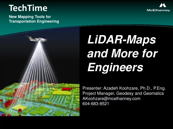
LiDAR-Maps and More for Engineers

Presenter: Azadeh Koohzare, Ph.D., P.Eng. Project Manager, Geodesy and Geomatics AKoohzare@mcelhanney.com 604-683-8521

slide-2
SLIDE 2

TechTime

New Mapping Tools for Transportation Engineering

TechTime

New Mapping Tools for Transportation Engineering

Slide #2 26/05/2009 9:13:34 AM

ALS50-II Leica components (Leica LiDAR Manual, 2007)

TechTime

New Mapping Tools for Transportation Engineering

McElhanney’s system

slide-3
SLIDE 3

TechTime

New Mapping Tools for Transportation Engineering

TechTime

New Mapping Tools for Transportation Engineering

RGB and NIR Digital Cameras

Rolleimetric AIC P65+ with RGB lens Rolleimetric AIC P45 with Near IR lens (same housing)

TechTime

New Mapping Tools for Transportation Engineering

McElhanney’s Cameras (linked to LiDAR)

slide-4
SLIDE 4

TechTime

New Mapping Tools for Transportation Engineering

TechTime

New Mapping Tools for Transportation Engineering

GPS Base

LiDAR Components:

  • GPS
  • IMU (Inertial Measuring Unit)
  • Scanner

Slide #4

Components of LiDAR

TechTime

New Mapping Tools for Transportation Engineering

slide-5
SLIDE 5

TechTime

New Mapping Tools for Transportation Engineering

TechTime

New Mapping Tools for Transportation Engineering

Slide #5 26/05/2009 9:12:54 AM

Grouse Mt, B.C.

Slide #5 26/05/2009 9:12:54 AM

TechTime

New Mapping Tools for Transportation Engineering

Designed Flight Lines

slide-6
SLIDE 6

TechTime

New Mapping Tools for Transportation Engineering

TechTime

New Mapping Tools for Transportation Engineering

  • Dense pickup of DEM mass points
  • Data reduction using Airborne GPS/IMU
  • Ground Kinematic
  • Result – Point cloud
  • Data classification from point cloud to Bare Earth
  • Creation of TIN’s, Contours and other products

LiDAR Process

TechTime

New Mapping Tools for Transportation Engineering

slide-7
SLIDE 7

TechTime

New Mapping Tools for Transportation Engineering

TechTime

New Mapping Tools for Transportation Engineering

McElhanney’s LiDAR Classification and Quality Control

TechTime

New Mapping Tools for Transportation Engineering

slide-8
SLIDE 8

TechTime

New Mapping Tools for Transportation Engineering

TechTime

New Mapping Tools for Transportation Engineering

  • Overlay Bare Earth Data
  • Scan Images for voids and

erroneous points

HIGH DEGREE OF CONFIDENCE

IN ALL DELIVERABLES

From Stereo Photo or LiDARgrams

TechTime

New Mapping Tools for Transportation Engineering

LiDAR Quality Control

slide-9
SLIDE 9

TechTime

New Mapping Tools for Transportation Engineering

TechTime

New Mapping Tools for Transportation Engineering

Photogrammetric WorkStation

TechTime

New Mapping Tools for Transportation Engineering

slide-10
SLIDE 10

TechTime

New Mapping Tools for Transportation Engineering

TechTime

New Mapping Tools for Transportation Engineering

Accuracy Expectations

  • Vertical accuracies Based on Project Reports

Grouse Mountain 10cm on Hard surfaces (95% confidence level) Kitsault 12cm on Gravel Surfaces Campbell River 20cm in Heavy Tree cover

  • Horizontal accuracies vary depending on flying

height and terrain surface

TechTime

New Mapping Tools for Transportation Engineering

slide-11
SLIDE 11

TechTime

New Mapping Tools for Transportation Engineering

TechTime

New Mapping Tools for Transportation Engineering

Page 8 of 32

Slide #11 26/05/2009 9:12:54 AM

The Value of LiDAR

slide-12
SLIDE 12

TechTime

New Mapping Tools for Transportation Engineering

TechTime

New Mapping Tools for Transportation Engineering

LiDAR data by Elevation

slide-13
SLIDE 13

TechTime

New Mapping Tools for Transportation Engineering

TechTime

New Mapping Tools for Transportation Engineering Profile view of LiDAR data

slide-14
SLIDE 14

TechTime

New Mapping Tools for Transportation Engineering

TechTime

New Mapping Tools for Transportation Engineering

Extracted LiDAR data over Orthophoto

slide-15
SLIDE 15

TechTime

New Mapping Tools for Transportation Engineering

TechTime

New Mapping Tools for Transportation Engineering

Slide #15 26/05/2009 9:12:54 AM

Profile view of LiDAR data

slide-16
SLIDE 16

TechTime

New Mapping Tools for Transportation Engineering

TechTime

New Mapping Tools for Transportation Engineering

Transmission Line from LiDAR data

Software can extract powerlines and store in vector format.

slide-17
SLIDE 17

TechTime

New Mapping Tools for Transportation Engineering

TechTime

New Mapping Tools for Transportation Engineering

Contours generated from LiDAR points

slide-18
SLIDE 18

TechTime

New Mapping Tools for Transportation Engineering

TechTime

New Mapping Tools for Transportation Engineering

Shaded relief with contours generated from LiDAR points

slide-19
SLIDE 19

TechTime

New Mapping Tools for Transportation Engineering

TechTime

New Mapping Tools for Transportation Engineering

Applications

  • f LiDAR
slide-20
SLIDE 20

TechTime

New Mapping Tools for Transportation Engineering

TechTime

New Mapping Tools for Transportation Engineering

Aerial Photograph

Kerr Sulphurets site

1000 m 100 m

Bare Earth LiDAR

slide-21
SLIDE 21

TechTime

New Mapping Tools for Transportation Engineering

TechTime

New Mapping Tools for Transportation Engineering

  • Civil engineering & Infrastructure development
  • Corridor mapping
  • Spatial planning
  • Flood monitoring
  • Landslide monitoring
  • Erosion monitoring
  • Coastline monitoring
  • Irrigation management
  • Coastline Analysis and Protection
  • Volumetric studies
  • Engineering Design (Transmission Lines)
  • 3D City Model and Asset Management Applications
slide-22
SLIDE 22

TechTime

New Mapping Tools for Transportation Engineering

TechTime

New Mapping Tools for Transportation Engineering

  • Kinskuch and Jade creek, near Stewart, BC.– 2008
  • Chilliwack Power Transmission– 2008
  • Campbell River, BC. University of British Columbia -2008
  • Kerr-Sulphurets-Mitchellin site northern Terrace, BC. -2008
  • Mtn Milligan, BC. -2008
  • Skeena Flood Plain Mapping-2008
  • Abbotsford Development-2008
  • Grouse Mt site in Vancouver, B.C. -2008
  • Galore Creek Mine site Galore Creek Mining Corp. - 2008
  • Pickle Lake Mine in northern Ontario-2008
  • Onion Creek - Smithers, BC. -2008
  • Maroon Creek in north west B.C. -2008
  • Fraser and Nechako River for hydraulic modeling- 2008
  • Urban and mountainous areas for geo-technical applications – 2007
  • SFPR – Gateway Program
  • Sechelt Inlet – Land Development
  • Sechelt Ledge/ Thornborough/ McNab Creek – Land development
  • Port Renfrew – ND Lea
  • Kitimat - PNG

Some Projects

slide-23
SLIDE 23

TechTime

New Mapping Tools for Transportation Engineering

TechTime

New Mapping Tools for Transportation Engineering

Slide #23 26/05/2009 9:12:55 AM

Slide #23 26/05/2009 9:12:55 AM

RGB Imagery NIR Imagery Combined RGB and NIR Images

+ =

slide-24
SLIDE 24

TechTime

New Mapping Tools for Transportation Engineering

TechTime

New Mapping Tools for Transportation Engineering RGB

GB and NIR and NIR Applica pplications tions

NIR/CIR

  • Agriculture
  • Forest Classification
  • Environmental Terrain Hazard Studies
  • Municipal Impervious Surfaces Analysis

RGB

  • Colour orthophoto
  • Photogrammetric data capture
slide-25
SLIDE 25

TechTime

New Mapping Tools for Transportation Engineering

TechTime

New Mapping Tools for Transportation Engineering

TechTime

New Mapping Tools for Transportation Engineering

THANK YOU!