
SLIDE 1
INTEGRATED GREEN INFRASTRUCTURE
Landscape Urbanism Design Strategy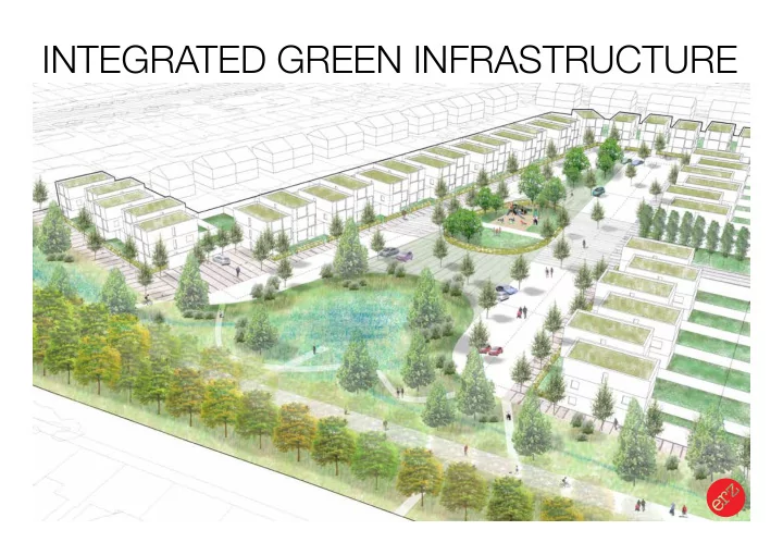
INTEGRATED GREEN INFRASTRUCTURE Landscape Urbanism Design - - PowerPoint PPT Presentation
INTEGRATED GREEN INFRASTRUCTURE Landscape Urbanism Design Strategy INTEGRATED GREEN INFRASTRUCTURE WHY? Landscape Urbanism Design Strategy THE WORLD IS MADE UP OF INTERCONNECTED SYSTEMS Landscape Urbanism Design Strategy Landscape
INTEGRATED GREEN INFRASTRUCTURE
Landscape Urbanism Design Strategy INTEGRATED GREEN INFRASTRUCTURE
Landscape Urbanism Design Strategy THE WORLD IS MADE UP OF INTERCONNECTED SYSTEMS
ROADS / TRANSPORT HABITAT NETWORKS ACCESS NETWORKS BUILT DEVELOPMENT WATER MANAGEMENT GREEN / OPEN SPACE
ROADS / TRANSPORT HABITAT NETWORKS ACCESS NETWORKS BUILT DEVELOPMENT WATER MANAGEMENT GREEN / OPEN SPACE
INTEGRATED GREEN INFRASTRUCTURE
Landscape Urbanism Design Strategy INTEGRATED GREEN INFRASTRUCTURE
Landscape Urbanism Design StrategySTRATEGY
NITSHILL / SW GLASGOW IGI GREATER EASTERHOUSE IGI
MASTERPLAN / DELIVERY
FORESTERHILL HEALTH CAMPUS IGI HALFWAY PARK IGI GLASGOW 2014 MGP: BARROWFIELD PARK
INTEGRATED GREEN INFRASTRUCTURE
Landscape Urbanism Design StrategySTRATEGY
NITSHILL / SW GLASGOW IGI GREATER EASTERHOUSE IGI
MASTERPLAN / DELIVERY
FORESTERHILL HEALTH CAMPUS IGI HALFWAY PARK IGI GLASGOW 2014 MGP: BARROWFIELD PARK
SOUTH-WEST GLASGOW / NITSHILL IGI
client: Glasgow & Clyde Valley Green Network Partnership / GCC team: ERZ & Enviro-centre (ecology / hydrology) HYDROLOGY: CATCHMENTS
Levern Water Brock Burn White Cart Water River Clyde HYDROLOGY: FLOODING
200 year pluvial fmood 30 year pluvial fmood 1984 fmood event URBAN STRUCTURE: BARRIERS
URBAN STRUCTURE: BARRIERS
URBAN STRUCTURE: DESTINATIONS
800m = 10 min walk 400m = 5 min walk URBAN STRUCTURE: DENSITY
WIDER GREEN NETWORK: GAPS
Pollok Country Park Dams to Darnley Country Park Rouken Glen Park STRATEGY: GREEN NETWORK
green network that functions on both a local and citywide level centre of Nitshill becomes a hub
point of arrival to Dams to Darnley Country Park and wider network make the green network accessible & visible & redefjne the character / identity of the area
STRATEGY: WATER
Peat Road corridor redesigned to manage surface water thro’ SUDs features such as: swales, linear wetland, tree planting etc. SUDs features associated with adjacent residential development site incorporated into linear park SUDs feature created as terminus to boulevard on cleared site: addressing water management requirements of surrounding development sites linear swale/wetland SUDs features incorporated into design
surface water in upper portion of catchment (south of rail line)
STRATEGY: OVERVIEW
DETAIL AREAS:
GREATER EASTERHOUSE IGI
client: Glasgow City Council / GCVGNP team: ERZ & Enviro-centre (ecology / hydrology) HYDROLOGY: CATCHMENTS
GREEN NETWORK: BREAKS
Glasgow
NCR 75 N C R 7 5 Strathkelvin Railway Path Glasgow to Cumbernauld 1kmGlasgow Coatbridge
0km 24kmGlasgow Coatbridge
0km 16kmNCR 75 7 Lochs Cycle Link
Coatbridge to Kirkintilloch Gartcosh Glenboig Bargeddie Rutherglen Bishopbriggs Airdire Blairtummock Cranhill Ruchazie Landscape Urbanism Design StrategyWIDER GREEN NETWORK:
STRATEGY:
DETAIL AREAS:
INTEGRATED GREEN INFRASTRUCTURE
Landscape Urbanism Design StrategySTRATEGY
NITSHILL / SW GLASGOW IGI GREATER EASTERHOUSE IGI
IN AREAS OF ANTICIPATED CHANGE PLANNING / DESIGN GUIDANCE CREATES COMMON PLATFORM OF UNDERSTANDING FOR ALL PARTIES NEED TO EMBED IN STATUTORY PROCESSES
INTEGRATED GREEN INFRASTRUCTURE
Landscape Urbanism Design StrategyMASTERPLAN / DELIVERY
FORESTERHILL HEALTH CAMPUS IGI HALFWAY PARK IGI GLASGOW 2014 MGP: BARROWFIELD PARK
FORESTERHILL CAMPUS
client: NHS Grampian / Green Exercise Partnership team: ERZ & Enviro-centre (ecology / hydrology) FORESTERHILL: 1944
EXISTING: ROADS / PARKING
FORESTERHILL GI MASTER PLAN
FORESTERHILL CAMPUS
FORESTERHILL CAMPUS
HALFWAY PARK
client: Southside Housing Association HALFWAY PARK
MGP 2014: CAMLACHIE
client: West of Scotland Housing Association / Glasgow City Council / CSGN MGP 2014: CAMLACHIE
MGP 2014: CAMLACHIE
MGP 2014: CAMLACHIE
MGP 2014: CAMLACHIE
INTEGRATED GREEN INFRASTRUCTURE
Landscape Urbanism Design StrategyMASTERPLAN / DELIVERY
FORESTERHILL HEALTH CAMPUS IGI HALFWAY PARK IGI GLASGOW 2014 MGP: BARROWFIELD PARK
PROBLEM SOLVING INTERVENTIONS DRIVEN BY NEED FOR CHANGE SEEK BETTER BALANCE OF ‘SYSTEMS’ IN BUILT ENVIRONMENT
ROADS / TRANSPORT HABITAT NETWORKS ACCESS NETWORKS BUILT DEVELOPMENT WATER MANAGEMENT GREEN / OPEN SPACE