
SLIDE 1
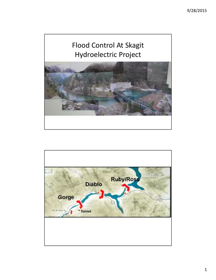
Flood Control At Skagit Hydroelectric Project 1 9/28/2015 Ross - - PDF document
9/28/2015 Flood Control At Skagit Hydroelectric Project 1 9/28/2015 Ross Reservoir full pool elevation 1,602.5 feet 23 miles in length surface area of 11,700 acres 1,052,323 Acre Feet of storage AF FERC-required flood
5000 10000 15000 20000 25000 30000
Jan Feb Mar Apr May Jun Jul Aug Sep Oct Nov Dec Discharge (cfs) 1922 1998
Storage of snowmelt
1586 1588 1590 1592 1594 1596 1598 1600 1602 1604 Ross Elevation (feet) Date
Skagit Flood Control Curve
Continues at 1,592' until April Complete Flood Pocket must be reached by November 30th each year Full Reservoir Elevation = 1,602.5 ft
Lake Elevation feet acre-feet second-foot-day acre-feet second-foot-day 1602.50 1,434,796 723,376 1602.00 1,428,856 720,382 5,940 2,995 1601.00 1,417,044 714,426 17,752 8,950 1600.00 1,405,321 708,516 29,475 14,860 1599.00 1,393,670 702,642 41,126 20,734 1598.00 1,382,073 696,795 52,723 26,581 1597.00 1,370,529 690,975 64,267 32,401 1596.00 1,359,040 685,183 75,756 38,194 1595.00 1,347,604 679,417 87,192 43,959 1594.00 1,336,222 673,679 98,574 49,698 1593.00 1,324,894 667,967 109,902 55,409 1592.00 1,313,620 662,283 121,176 61,093 1591.00 1,302,400 656,626 132,396 66,750 1590.00 1,291,233 650,997 143,563 72,380 1589.00 1,280,120 645,394 154,676 77,982 1588.00 1,269,061 639,819 165,735 83,558 1587.00 1,258,056 634,270 176,740 89,106 1586.00 1,247,105 628,749 187,691 94,627 1585.00 1,236,208 623,255 198,588 100,121 1584.00 1,225,365 617,788 209,431 105,588 1583.00 1,214,575 612,348 220,221 111,028 1582.00 1,203,839 606,936 230,957 116,441 Reservoir Volume Flood Control Volume
Full Reservoir Flood Control Elevation Skagit River Project FERC License The Skagit River Project is licensed by FERC. (30 year license) Article 36 of the license contains the following Flood Control provision: "The Licensee shall reserve a maximum of 120,000AF of storage space in Ross reservoir for flood control during the period from October 1 through, and to include, March 15. The required storage space, if not previously obtained through power withdrawals, shall be provided by drawing down the reservoir at a rate equaling or exceeding a uniform drawdown rate from zero on October 1 to a rate that provides 60,000 AF
provide the full 120,000 AF on December 1, with the reservoir level at El l592.0 ft. Whenever the National Weather Service, Northwest River Forecast Center, forecasts that the natural flow at the gaging station near Concrete, Washington will equal or exceed 90,000 cfs in 8 hours on a rising stage of a flood, the Licensee shall, as a maximum, release only such flows from Ross dam as are necessary to the normal production of electric energy at Ross, Diablo, and Gorge plants, but no more than a mean daily discharge of 5,000 cfs, plus or minus 20 percent allowance for
"If the reservoir pool should reach the elevation of EI 1602.5 ft before the flood recession occurs, the gates shall be operated to produce maximum surcharge storage to gain the maximum reduction of discharge
long as possible, or until flood recession occurs. After flood recession starts, releases from Ross reservoir shall be increased until discharge equals inflow. Storage shall be evacuated as rapidly as possible without endangering downstream installations as soon as the discharge at Concrete recedes to 90,000 cfs and a falling trend is predicted."
USGS Instantaneous Peak Flows (CFS) 2003 1995 1990
Where the Flood Water Comes From (Marblemount Flow Origins)
Two separate flood peaks
First Peak Reduced At Newhalem Ross refilled during first flood
Flood Pocket Elevation 1592 feet 30+ days to recreate flood pocket
Ross Full
Flood Year Newhalem Highest Average Daily Peak Flow Tributary Flow (New- Rockport) Marblemount Flow (cfs) Newhalem Gage + Natural Flow Hold Back Holdback Actual Marblemount Stage (ft) Estimated Marblemount Gage Flow Including Estimated Holdback Estimated Additional Stage Increase
1990 27,000 23,000 50,000 52,000 25,000 12 75,000 3.4 1995 29,000 21,000 50,000 46,000 17,000 12 67,000 2.4 2003 32,000 10,000 42,000 47,000 15,000 11 57,000 2.1
Comparative Flows & River Stage Heights At Ross Reservoir, Newhalem and Marblemount During the 1990, 1995 and 2003 Floods