
SLIDE 1
Development of Survey Procedures and Measurement System for the Detecting concentration of residual radioactivity in Decommissioning of NPP
Ga-Yeong Kim, Ki-Hyun Kwon, Yun-seo Go, Seung-Geon An Sunkwang T&S Co.,Ltd Sunkyung Officetel 20F, #3, Gongwon-ro, Guro-gu, Seoul 08298, Republic of Korea
*Corresponding author: kykim@sktns.co.kr
- 1. Introduction
As the country's first commercial reactor, the Kori No.1 reactor, was permanently shut down in June 2017, it is required to apply for approval for decommissioning by 2022. The Nuclear Safety Act regulates that the plan shall describe the methods and procedures for the survey types, quantities and distributions of radioactive materials at the facilities and sites subjected for the application for approval of decommissioning. In addition, in
- rder
to complete the decommissioning, the nuclear operator shall present radiological survey plans, methods, results and reuse plans of the sites for the final state and demonstrate meeting the dose criteria. Therefore, in decommissioning of Nuclear power plants, the detection of residual radioactivity at the site is an important and basic activity that establishes the plan, verifies the final radiological state of the site and determines the time and cost of the work as a result. In this study, developed a system for detecting residual radioactivity to determine the effects of the activity, the scope and characteristics of contamination, and a procedure to survey contamination levels of soil surface using this system.
- 2. Methods and Results
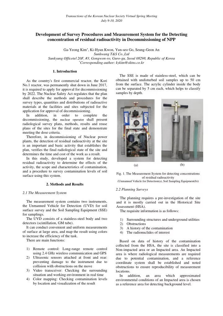
2.1 The Measurement System The measurement system contains two instruments, the Unmanned Vehicle for Detection (UVD) for soil surface survey and the Soil Sampling Equipment (SSE) for samplings. The UVD consists of a stainless-steel body and two detectors (scintillation, GM tube). It can conduct convenient and uniform measurements
- f surface at large area, and map the result using colors
to increase the efficiency of the task. There are main functions: 1) Remote control: Long-range remote control using 2.4 GHz wireless communication and GPS 2) Ultrasonic sensors attached at front and rear: preventing damage to the instrument due to collision with obstructions on the move 3) Video transceiver: Checking the surrounding situation and working environment in real time 4) Color mapping: Checking contamination levels by location and visualization of the result The SSE is made of stainless-steel, which can be
- btained with undisturbed soil samples up to 50 cm
from the surface. The acrylic cylinder inside the body can be separated by 5 cm each, which helps to classify samples by depth. (a) (b)
- Fig. 1. The Measurement System for detecting concentrations
- f residual radioactivity
(Unmanned Vehicle for Detection(a), Soil Sampling Equipment(b))
2.2 Planning Surveys The planning requires a pre-investigation of the site and it is mostly carried out in the Historical Site Assessment (HSA). The requisite information is as follows: 1) Surrounding structures and underground utilities 2) Obstructions 3) A history of the contamination 4) The radionuclides of interest Based on data of history of the contamination collected from the HSA, the site is classified into a Non-impacted area or an Impacted area. An Impacted area is where radiological measurements are required due to potential contamination, and a reference coordinate system shall be established and noted
- bstructions to ensure reproducibility of measurement