SLIDE 1 1 Cloverdale History Presentation These notes accompany a PowerPoint presentation that was given by Beth Putnam Cole and George Putnam to the Cambridge (VT) Historical Society
- n Wednesday, July 12, 2017 and the Westford (VT) Historical Society on
Monday, July 17, 2017. This is by no means a complete history of Cloverdale. We merely summarize some highlights of earlier research done by our forebears – see the notes for slides 1 and 2. Slide 1 Cover of book by Harold Putnam and Jane (McClure) Clark Brown that served as the basis for this presentation: Cloverdale: An Anecdotal History
- f A Rural Neighborhood, June, 2001. (Hereafter the Cloverdale book.)
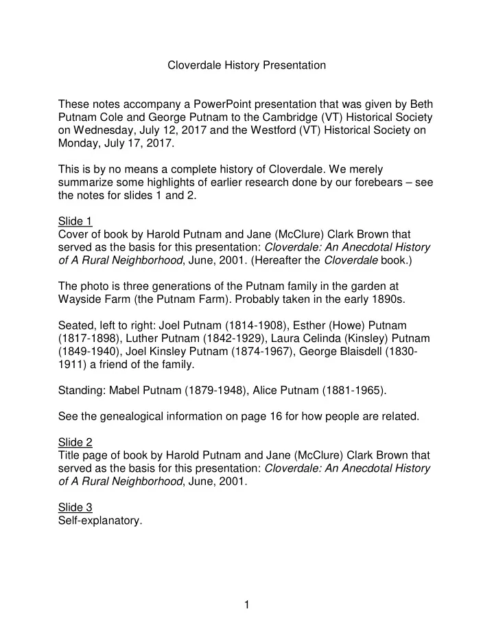
The photo is three generations of the Putnam family in the garden at Wayside Farm (the Putnam Farm). Probably taken in the early 1890s. Seated, left to right: Joel Putnam (1814-1908), Esther (Howe) Putnam (1817-1898), Luther Putnam (1842-1929), Laura Celinda (Kinsley) Putnam (1849-1940), Joel Kinsley Putnam (1874-1967), George Blaisdell (1830- 1911) a friend of the family. Standing: Mabel Putnam (1879-1948), Alice Putnam (1881-1965). See the genealogical information on page 16 for how people are related. Slide 2 Title page of book by Harold Putnam and Jane (McClure) Clark Brown that served as the basis for this presentation: Cloverdale: An Anecdotal History
- f A Rural Neighborhood, June, 2001.
Slide 3 Self-explanatory.
SLIDE 2 2 Slide 4 – What is Cloverdale? Cloverdale was a close-knit community that lasted for more than 150 years. It began in 1804 and lasted until the 1950s and 1960s when we (Beth and George and our siblings) were growing up on the Putnam Farm. Our aunt, Elizabeth Putnam1, who grew up on the Putnam Farm in the 1920s and 1930s, once wrote a few paragraphs about her recollections of
- Cloverdale. They are included in the Cloverdale book in a section titled
“Neighboring.” She wrote about the mutual helpfulness among the neighborhood families whenever there was work to be done. She wrote about neighborhood birthday parties, and box parties at the Cloverdale School where young men and women courted each other. She wrote: The greater part of our social life centered around Cloverdale. 4-H and Home Dem2 were the basis for frequent meetings and there were many neighborhood get-togethers that required no
- rganizational backing at all. …
How thankful I am that I could have my growing-up years in a place where people not only knew each other, but really cared about their neighbors. And with that introduction, let’s talk about where Cloverdale was.
1 Mary Elizabeth Putnam (1917-1997), known as Elizabeth or Beth. Sister to Harold Putnam. Her beau
was killed in the Battle of the Bulge, and she did not marry until late in life (1976) when she married Seldon Taylor. Then she was Elizabeth Taylor!
2 “Home Dem” is short for Home Demonstration. “Home demonstration clubs were an integral part of the
U.S. Department of Agriculture Cooperative Extension Service, which was established during the early twentieth century as an experiment in adult education, providing agricultural demonstration work for men and home demonstration work for women. The home demonstration work taught farm women improved methods for accomplishing their household responsibilities and encouraged them to better their families’ living conditions through home improvements and labor-saving devices. Beyond just the realm of the individual family, the clubs also became sources of education and charity in communities.” Source: The Encyclopedia of Arkansas History & Culture. The Cooperative Extension Service was created by the Smith-Lever Act of 1914.
SLIDE 3 3 Slide 5 If you type “Cloverdale” into Wikipedia, it will redirect you to Westford, and it won’t tell you much more than that Cloverdale is a hamlet in the town of
- Westford. But Google Maps knows where Cloverdale is! Google Maps puts
Cloverdale at the intersection of Seymour Road and Vermont Route 15. Slide 6 Here is what that intersection looks like today. Note the road signs and the location of K & R Automotive Repair. Slides 7 and 8 Cloverdale is all of Vermont Route 15, plus nearby areas, from the Putnam Farm to the Cloverdale Farm—about three miles. Cloverdale is the portion
- f Vermont Route 15 that is in the town of Westford, plus the Putnam Farm.
The Putnam Farm is in the town of Cambridge, but adjacent to the Westford town line. The Cloverdale Farm is opposite George Scatchard Lamps & Pottery on Route 15. Slide 9 This map shows Cloverdale in relation to other towns. It is the northeast corner of Westford plus the Putnam Farm. The Putnam Farm is in the western part of Cambridge where three counties and five towns approximately come together. We are not certain, but we think that at one time the Putnam Farm (before it was the Putnam Farm) may have been in a different town, at least in part. Early maps show the Fairfax/Fletcher line extending to the point where Westford, Underhill and Cambridge currently meet. At that time, three counties and five towns truly met at a point. That point is on the edge of the Putnam sugarbush. The Fairfax/Fletcher line was truncated at the Lamoille River, we believe in the early 1840s. The Putnams moved to the Putnam Farm in 1854, at which time it was in Cambridge. Slide 10
- F. W. Beers published maps of many areas in the northeastern United
- States. This map of Westford is from the F. W. Beers Atlas of Chittenden
County, published in 1869. Note what is now Route 15 in the northeast corner of Westford. The village of Cambridge is on this road, off the map to the north. The village of Underhill Flats in on this road, off the map to the south.
SLIDE 4 4 The village of Westford Centre is approximately in the middle of the map. There is a road from Cloverdale to Westford Centre, but it goes over a hill (Number Eleven Hill) and it was never a good road. It has not been open for a long time. On the Cloverdale side, it is now called Seymour Road. We knew it as Old Number 11 Road, and it is still called that on the Westford village side. Because of the range of hills that separates Cloverdale from the center of Westford, the easiest way to travel from Cloverdale to the village of Westford is to go north to the Lamoille River (off the map), then west along the Lamoille River, and then south to the village of Westford. On this map, note Beaver Brook which flows north from Cloverdale to the Lamoille River (off the map).3 We’ll have more to say about this brook later. Later we will talk about the railroad, but the railroad came in 1877 and this map was published in 1869, so there is no railroad on this map. Slide 11 – 1804 Settlers In the fall of 1804 at least 12 and possibly as many as 14 families traveled together from the Hollis area in southern New Hampshire, in the Merrimack Valley, to what we now call Cloverdale in Westford, Vermont. They
- riginally called the area they settled “Hampshire Corners.”
Slide 12 This map shows the possible route they took, likely crossing the Connecticut River at Bellows Falls. They traveled as a group, leaving on October 13, 1804, and arriving on October 27, 1804, a trip of two weeks. Slide 13 This list shows the most likely members of the group that traveled from Hollis, NH to Westford, VT. A few comments about some of these people: · Caleb and Dorcas Eastman were a young couple in their 20s. · Shebuel Hobart was 89, and was the first person in the group to be buried in the new cemetery the following year at age 90. · Jonas and Sally Hobart were a young couple in their 20s.
3 You may have to expand the map to see Beaver Brook.
SLIDE 5 5 · David McClure and Mary Atwood were among the children who came to Cloverdale; they later married. Slide 14 This map shows land purchases by the New Hampshire folk that are recorded in Westford archives. The dotted line shows the future Route 15. The cemetery is about in the middle. The Barron lot later became the Putnam Farm. The Woods lot later became the Cloverdale Farm. All the names on this map appear on the previous slide except “Hayden.” However, no one can remember anyone except the Haydens being on that lot until 1973 when it passed out of the Hayden family to the Leach family. Old land records can be frustrating. In the Cloverdale book, Jane Clark Brown wrote: “We can only guess that the rest of the Hollis people settled
- n the lots between Hayden and Nutting.”
Slides 15 and 16 The Jordan house is at the intersection of Bill Cook Road and Route 15. This later was the Harry and Florence Allen house, and was restored in 1976 by their son Stearns Allen, Sr. His wife Betty still lives in this home. Slides 17 and 18 What our father always called the McClure house is adjacent to the Cloverdale Cemetery (north of the cemetery), although the original map shows the current Huffman place as the original McClure place. The boy [in slide 17] is reported to be Glen Gomo and the woman his mother? [Various captions in Harold Putnam’s notebooks say: Home of D. W. (David Woods) McClure (1796-1888), north of Cloverdale Cemetery, Westford,
- VT. Where railroad laborers were fed, and the site of a near hanging. Also
referred to as the Jim McClure house. Glen Gomo in chair.] Slide 19 The Cloverdale Farm house. This lot was owned through the years by David Woods, according to the map, Robinson, Bliss, Sinclair, Blondin, then Cross in 1931, sold in 1960s. We aren’t sure who built the house, but likely Robinson or earlier. The 1869 Beers map (slide 10) shows “A. Robinson” as living here. That is almost certainly Asher Robinson, father of Minnie Robinson—more about her later.
SLIDE 6 6 According to Juanita Cross Shedd (1925-2010) who grew up on the Cloverdale Farm, it was a beautiful 3-story house, “a great house with many rooms.” This house burned on March 10, 1938. Slide 20 A smaller house was built to replace the Cross’s lost home. The house in this photo is presumed to be this small one, built on the spot where the big “mansion” had been. This house is now vacant. Slides 21-23 The Cloverdale Farm barn through the years. This was a large, progressive
- farm. Note the three barn bays and the silos on the end. In slide 22, there is
an apartment in the far end of the barn. In slide 23, the silos are gone. Slide 24 Hobart house. Hobarts originally settled on lots below Route 15. Through the years they have added to their property. This house was built in the 1870s. Slide 25 The Jackson Place on Route 15 near Bill Cook Road. Harry and Florence Allen lived here. This house is now gone. Slide 26 The Hayden house on Route 15 near Allen Irish Road. The Haydens stayed on this property until 1973 when Bill and Jan Leach bought it. It remains in the Leach family. The last Haydens to live there were 3 maiden sisters, one of whom helped out at the Putnam Farm as long as she was able, well into the 1960s. Same builder as Hobart house [slide 24], both built in the 1870s. Slide 27 The Allen Irish house on Allen Irish Road, the cross road between Route 15 and Route 104. It is in the town of Westford and was considered part of
- Cloverdale. Allen and Evelyn (Church) Irish lived here. Currently owned by
Tony Kitsos.
SLIDE 7 7 Slide 28 The Allen Irish barn which in 1996 was dismantled, moved, and rebuilt off Woods Hollow Road in Westford for a member of the rock bank Phish as a recording studio. Slide 29 The old Barron house on the Putnam farm that was used as a bunkhouse for workers on the railroad when it was built in 1877. They were fed in the new Putnam house (across the yard, not in the photo) which had been built in 1867. It was said that Esther Putnam used a barrel of flour a week to feed the railroad workers. This house at different times was a home for the Barrons, then the Joel Putnams, then the Putnam in-laws, railroad workers, hired help, and in living memory for chickens and pigs. It is gone now. The date of the photo is not known. Slide 30 Cloverdale Cemetery – where most of these early settlers were buried, the first to be Shebuel Hobart, a year or so after their arrival. And sadly, there are many infants and young children here, also. Slide 31 – Early Life and Infrastructure Slide 32 Let’s review what we mean by Cloverdale. This is a 1948 topographic map.4 By Cloverdale we mean Vermont Route 15, plus nearby areas, from the Putnam Farm in the town of Cambridge to the Cloverdale Farm on the Westford/Underhill town line—about three miles. Cloverdale is mostly in
- Westford. The village of Westford is off the map to the left. The village of
Cambridge is visible at the upper right. The village of Underhill Flats is off the map to the bottom. The cemetery is in the middle of Cloverdale.5 The main occupation of the early settlers was farming. They had to be nearly self-sufficient, and they planted pumpkins, squash, turnips, beans, wheat, corn, potatoes, flax, and apple trees. They tapped maple trees. They cleared land, and converted some of the fallen trees to potash.
4 15 minute series, Mount Mansfield quadrangle 5 If you magnify the map, you will see that it is labeled as North Underhill Cemetery. We know it as
Cloverdale Cemetery.
SLIDE 8
8 Slide 33 Potash was big business in the late 1700s and early 1800s. It was “America’s first industrial chemical.” It was used in many manufactured products, including soap, glass, dyes and gunpowder. It could be exported to England for use in the textile industry. It was probably the first cash crop. Potash (potassium chloride) was made by burning hardwood logs, mixing the ashes with lime and water, boiling in potash kettles, and then letting it cool. The two photos are potash kettles (turned on their side) at Beth’s house and on the Putnam Farm. Slides 34-35 One of the first things the settlers built was a grist mill on Beaver Brook. There is only a little stone work left now. These pictures were taken below the old schoolhouse (at the site indicated in slide 42). Audience input 7/17/17: Kyle Hobart said this was the site of a sawmill, and that the grist mill was further north (downstream) toward the Lamoille River. Tony Kitsos confirmed that David Irish, son of Allen Irish, once showed him the grist mill site, below the Allen Irish farm. Slide 36 Also one of the first things the settlers built was a school. The school shown in these photos was not the first school they built. It was probably the third school, and it was in operation (eight grades) until the 1950s. The 1869 Beers map (slide 10) shows two school districts in Cloverdale – Districts 7 and 9 – and the location of their schools. The two districts merged in 1890 and a new schoolhouse, shown in these pictures, was built at the location shown as “Westford Sch” on the 1948 topo map (slide 32). Although there was a cemetery in Cloverdale, there was no church. Most residents probably went to Cambridge village for church. However, Sunday School was held at the regular school, according to Harold Putnam’s notebooks. Audience input 7/12/17: Wendell Weston said he attended this school through grade 7 when it closed. He attended grade 8 at the elementary
SLIDE 9 9 school in Westford village. Wendell thought the Cloverdale School closed in 1959. Some Cloverdale teaching stories: Hattie McClure (1869-1948) grew up in the McClure house (slide 17) next to the Cloverdale Cemetery. In 1882 she passed her written and oral exams for teaching and was given a little school in Pleasant Valley. She was 13. The following year she taught at the District 7 School in
- Cloverdale. Safford Putnam (1870-1898) lived nearby at the Putnam Farm.
He went on to Prof. Cilley's Academy on Cilley Hill in Jericho, then to Montpelier Seminary, then to Connecticut Wesleyan to become a minister. He married Hattie McClure in 1892 and they had a child Anne Putnam. Safford took up a ministry in Bondville, Vermont, but he died there in 1898, and Hattie and three-year old baby Anne came back to Cloverdale.6 Both Safford and Hattie are buried in the Cloverdale Cemetery, as well as Anne Putnam Clark (1895-1973), who was Jane Clark Brown’s mother. Jane Clark Brown was one of the authors of the Cloverdale book. For Hattie's last year at the Cloverdale District 7 School as a student, her teacher was Minnie Robinson. Miss Robinson taught at Cloverdale for a few years before her marriage. More about her later. Slide 37 The railroad came to Cloverdale in 1877 and continued for about 60 years. The B & L Railroad (Burlington & Lamoille) went from Essex Junction to Cambridge Junction. This photo shows the last train in 1938 crossing Route 15 about where K & R Automotive Repair is. There was freight service to Cloverdale, but no passenger service. For passenger service, one would go about a mile south to North Underhill Station, or four miles northeast to Cambridge village. Slides 38-39 The Cloverdale Creamery was built in 1886 next to the railroad. It processed milk from about 400 cows, especially from the Cloverdale Farm, and shipped cream to Hartford.
6 After Safford’s death at age 28, his widow remarried an Otis. Safford’s widow Hattie (McClure) Putnam
Otis should not be confused with Safford’s sister Hattie (Putnam) Felton.
SLIDE 10 10 The Cloverdale Creamery churned milk into butter until hand separators came in. Then each farmer separated their own, selling cream and butter. In 1925 or so, whole liquid milk became a selling product, as electricity had come to many areas and could keep the milk cold. Other products shipped by rail from Cloverdale to distant markets included livestock, maple syrup and maple sugar, lumber, and potatoes and apples, especially from Luther Putnam’s Westview Farm. Inbound trains brought the mail, mail-order goods, and the occasional barrel of oysters on ice. Slide 40 K & R Automotive Repair is built on the site of the former Cloverdale Creamery. Slide 41 The house across the road from K & R Automotive Repair is thought to have been the home of the manager of the Cloverdale Creamery. Audience input 7/17/17: Kyle Hobart said he thought the creamery manager’s house was the next house north of this house, no longer standing. Slide 42 This map7 shows the location of things discussed in the preceding slides. The former railroad track is the dashed line that goes down the center of the map, crossing Route 15 near the word “Cloverdale.” The Cloverdale Creamery and freight railroad station were in the triangle formed by the railroad track, Route 15, and Seymour Road. That is where K & R Automotive Repair is now. The Cloverdale School (“Westford Sch” on the map) was on Route 15 just north of there. At the time of this map (1948) the train had only been gone 10 years, and the school was still in operation. The Cloverdale Cemetery is just off the map to the north.
7 1948 topographic map, 7.5 minute series, Underhill quadrangle
SLIDE 11
11 Slide 43 – Two Weddings, 1886 and 1911 Slide 44 The Robinson family lived at the Cloverdale Farm. On May 26, 1886, Minnie Robinson was married at the Cloverdale Farm to Fletcher Proctor. A special boardwalk was built from the house to the railroad tracks, and the train heading into Burlington stopped, as pre-arranged, to let the newlyweds board en route to Sutherland Falls. Fletcher Proctor’s father, Redfield Proctor, had been Governor of Vermont for a term (1878-1880). Fletcher later became President of Vermont Marble, then Governor for a term in 1906-1908. Fletcher and Minnie’s son Mortimer Proctor was Governor from 1945-1947. Cloverdale was always proud of its own First Lady of Vermont. Proctors were among the first settlers in Cloverdale. Although Fletcher Proctor was from Proctor, Vermont, it is possible that he met Minnie while visiting relatives in Cloverdale. Slide 45 Joel Kinsley Putnam (1874-1967), our grandfather, known as Kinsley, had been farming on the Putnam Farm when he met Mabelle Butler (1881- 1949), originally from Johnson, but now living in St. Albans and working as a nurse there. They married on December 25, 1911, at the Putnam Farm. Note that the photo is taken outside, that there is no snow, and they don’t appear to be freezing. From the write-up in the Suburban List there were 20 people at their wedding at noon followed by a meal. This wedding dress was described as being made of white marquisette over white silk, and they took the train from Cambridge Junction for their wedding trip. (Beth still has the dress, and it was displayed at both presentations.)
SLIDE 12 12 Slide 46 – Wayside Farm and Westview Farm The current Putnam Farm was called Wayside Farm. The current Huffman place was called Westview Farm. The two farms are adjacent, one in Cambridge and one in Westford. Slide 47 The Barron family (Benjamin, Sarah, 6-year-old Alvah) came to Cloverdale with the group from Hollis, NH in 1804 and settled on the current Putnam
- Farm. Alvah married a Fletcher girl named Fanny Kinsley. In 1854 they
sold the 100-acre farm to Joel Putnam for $3,000, and they went with
- thers to a commune in Oneida, New York, that eventually became Oneida
Community Ltd., a producer of silver-plated tableware, and one of the earliest joint-stock companies in the United States. All the buildings that were present when Joel Putnam purchased the farm from the Barrons in 1854 were altered or moved at least once in his
- lifetime. [See slide 29 for the old Barron house.] All those buildings from
1854 are now gone. Joel built this house in 1867 shortly after the Civil War, when good workers could be hired for $1.00/day plus board. Slide 48 This is the Putnam house today. Our brother Bill Putnam and his wife Donna live on the farm now. Slide 49 Sugaring has always been big in Cloverdale generally, and with the
- Putnams. This slide shows five sugarhouses on the Putnam Farm. At the
upper left is a sugarhouse that Joel Putnam moved and built in 1863. He moved a shed from the old house up the hill to be a sugarhouse. This shed was about 20' x 36', and was loaded on skids in the fall. At the first snowfall, it was pulled up the hill by neighbors with 19 yoke of oxen, pulled the distance without stopping. It was set near where Bill's newest sugarhouse is today (the photo at the lower right). The second sugarhouse on the farm is in the second picture down on the
- left. It was above Bill’s current sugarhouse, set up in the woods out of sight
from Route 15. It was built in the 1936 and burned in 1968. This is the sugarhouse that we remember from our growing up years.
SLIDE 13 13 The third sugarhouse is pictured at the bottom left. Each of the other sugarhouses was (or is) located above Route 15, but this sugarhouse was located below Route 15, below the farm. This small sugarhouse, built in 1969, was used to produce only enough maple syrup for family use, until Bill returned home from college in 1972 and built the fourth sugarhouse in the winter of 1975-76, shown in the upper photo on the right. This was the sugarhouse for two sugarbushes, the Putnam Farm and the Boyden Farm, which adjoins the Putnam Farm to the northeast toward Cambridge village. The fifth and current sugarhouse was built in 2001. This modern sugarhouse now boils sap from 3,650 taps. Slide 50 Joel Putnam (1814-1908) had 3 sons. Two died as infants and Luther Putnam (1842-1929) was the only child to live to adulthood. Luther in 1872 at 30 years old with his 2nd wife bought what is now the Huffman place, next door to the Putnam Farm (i.e., Wayside Farm), and called it Westview Farm. Joel and Luther farmed together for many years in the 1880s and into the
- 1890s. Theirs were dairy farms, with sugaring as well. Joel also did some
“teaming” and built stone walls for hire. He would lay up a single stone wall in a day for $1.00 a rod if the stones were brought to him. Luther became interested in horticulture, beginning with potatoes. He was known as the Potato King, taking many prizes for his potatoes at county and state fairs, and propagating new varieties. Later he became known for apples. He called himself a grower, market man and exhibitor. He also grew strawberries and other vegetables as cash crops, as well as selling young apple and other fruit trees, strawberry plants and seed potatoes. The
- rchards later suffered from freezing (hailstones in 1918) and borers and
“they are about whipped” (in the words of our grandfather in the family history written in 1948). Luther sold some of his apples and other fruit at the roadside stand in this
- photo. He also shipped product via rail to Massachusetts.
SLIDE 14 14 Slide 51 This photo shows the building that Luther Putnam originally built at Westview Farm in 1895 to store apples. It was called the “fruit house.” Later it was converted to a dwelling. Henry and Joyce Coolum lived there for many years. Slide 52 This photo shows the barn at Westview Farm in 2008. Slide 53 This photo shows the barn at Westview Farm today. The Huffmans have completed significant renovations on this barn. Slide 54 This photo shows the Huffman house at Westview Farm today. This house was built in the 1930s. Luther Putnam had two wives (Laura Safford and her cousin Laura Celinda Kinsley) and nine children. Only five children lived to adulthood and had children of their own: Hattie and Safford by his first wife; Kinsley, Mabel and Alice by his second wife. Hattie, Safford and Mabel married and moved
- away. (See the notes for slide 36 and the genealogical information on page
16 for more details.) Alice married Lester Cook and they took over Westview Farm from her father, Luther. Kinsley, our grandfather, took over Wayside Farm from his grandfather, Joel. We only remember dairy cows and maple sugaring on Westview Farm when Alice and Lester Cook operated it, not potatoes, apples and
- strawberries. The horticultural phase on the farm mostly ended when
Luther Putnam died in 1929. One of the Cook’s children was Bill Cook, the long-time postmaster in Underhill, for whom Bill Cook Road is named. His wife Pauline Cook was a teacher at the Cloverdale School until it closed in the 1950s. One of their children, Phil Cook, was a professor of botany at the University of Vermont for 30 years, so that is where the horticultural interest lived on. Westview Farm passed out of the family when Alice Cook died in 1965.
SLIDE 15
15 Slide 55 We are going to end this presentation with a party. Luther Putnam was a charter member of the Vermont Horticultural Society. In August 1914, he hosted a meeting of the Vermont Horticultural Society at Westview Farm. Over 500 people attended. We think this is the biggest party that Cloverdale has ever seen! Slide 56 They toured the orchards. Slide 57 They visited the fruit house. There were speeches. Slide 58 They visited the farm house. (The house in this photo was moved about 50 yards north in the 1930s, and replaced by the current Huffman house – see slide 54. The house in this photo continued to be used, at its new location, until the 1960s. It burned in the 1970s.) Slide 59 And entertainment was provided by the Westford Town Band! Slide 60 The end.
SLIDE 16
16 Genealogical Information Genealogical information about the people in the photo on the cover of the Cloverdale book, the authors of the book, and the hosts of this presentation: Luther Putnam (1842-1929) was the only child of Joel Putnam (1814-1908) and Esther (Howe) Putnam (1817-1898) to reach adulthood. Luther had two wives. He married Laura Safford (1840-1870) in 1863. They had three children: Hattie (Putnam) Felton (1865-c1935), Annie Putnam (1868-1888), and Safford Putnam (1870-1898). Laura (Safford) Putnam died in 1870 during or shortly after giving birth to Safford. Safford was the grandfather of Jane Clark Brown (1930-2009), one of the authors of the Cloverdale book. See the notes for slide 36 for more information about Safford. In 1872, Luther married Laura Celinda Kinsley (1849-1940), usually known as Celinda, a cousin to Laura Safford. They had six children. Three children died young in 1881, 1882 and 1883, before the photo on the cover of the Cloverdale book was taken. Three children lived to adulthood and are in that photo: Kinsley (1874-1967), Mabel (1879-1948) and Alice (1881-1965). Kinsley’s full name was Joel Kinsley Putnam, but he was known as Kinsley to avoid confusion with his grandfather Joel. Alice Putnam married Lester Cook and they took over Westview Farm from Alice’s father, Luther Putnam. Kinsley Putnam married Mabelle Butler (slide 45) and they took over Wayside Farm from Kinsley’s grandfather, Joel Putnam. Kinsley and Mabelle had two children: Harold (1914-2013) and Mary Elizabeth (1917-1997), known as Elizabeth or Beth. Harold was one of the authors of the Cloverdale book. Beth Putnam Cole and George Putnam, the hosts of this presentation, are two of the four children of Harold and Lois (Gould) Putnam.
SLIDE 17 17 Questions that were asked Was Cloverdale settled at about the same time as the surrounding area? The first settlers arrived in this area from elsewhere in New England as follows: · Cambridge 1783 · Underhill 1786 · Westford 1787 In other words, this area was settled shortly after the end of the American
- Revolution. (The treaty ending the war was signed in 1783. The last
significant battle – Yorktown – was fought in 1781.) The northeast corner of Westford known as Cloverdale was settled a little later, in 1804, presumably because it was somewhat isolated. Cloverdale was situated between the town centers of Westford, Cambridge and
- Underhill. A range of hills to the west made it more difficult to travel to
Westford Center than to Cambridge village to the northeast or Underhill Flats to the south, yet Cloverdale was not in either of those towns. It was in the town of Westford. These facts contributed to the development of Cloverdale as a distinct community. It is interesting to note that the first settlements in the three towns occurred during the period when Vermont was an independent republic (1777-1791), while the first settlement of Cloverdale in 1804 was after Vermont became the 14th state in 1791. This does not appear to have significantly affected the development of Cloverdale or any of the three towns.
SLIDE 18 18 Why did the families move from Hollis, NH to Westford, VT? In the Cloverdale book, Jane Clark Brown wrote: We can only guess why they were leaving an established way
- f life in New Hampshire. Perhaps they were responding to the
same restlessness that brought their ancestors across the Atlantic to Massachusetts and Connecticut. George Washington in 1798 said: “The inhabitants of New England are constantly spreading themselves.” Perhaps the Hollis area had become too crowded for them. It has been estimated that at the turn of the century the population along the Merrimack River reached 15 persons per square mile, about half again as much as Massachusetts and almost twice that of Vermont. In the early 1800s practically all the farming land available in the southern two-thirds of New Hampshire was already under cultivation. Unlike southern New Hampshire, northern Vermont was still sparsely populated. Up until the end of the Revolution, the threat of British armies and unfriendly Indians had discouraged permanent settlement. With peace and the resolution of land disputes, the area had become attractive to homesteaders. Our travelers were farm families who needed expansion room so their numerous children could also become farmers. One assumes it was at least partly because of this that they headed into the Vermont wilderness.
SLIDE 19 19 What did the settlers pay for their lots? In the Cloverdale book, Jane Clark Brown wrote: We also know by land records that Levi Nutting of Hollis had purchased 150 acres in that part of Westford in May, 1803 for $600. James McClure had come to Vermont in February, 1804 and purchased Westford lot 67, 3rd division (100 acres for $223); Thomas Atwood in the same month bought lot 43, 4th division (70 and ½ acres for $141); and Solomon Hobart in May purchased three 4th division lots of 70 and ½ acres each (for $422). All but the Nutting land was purchased from Thaddeus Tuttle of Burlington, described in a Chittenden County history as “a wealthy merchant who owned vast tracts of land all through Northern Vermont.” And as noted on slide 47, we know that Joel Putnam purchased the 100-acre Barron place in 1854 for $3,000. But that was 50 years after the
- riginal settlers arrived from Hollis, NH and included buildings.
Where did the name Cloverdale come from? The Hollis, NH settlers originally called the area “Hampshire Corners,” which is understandable considering where they came from. We don’t know exactly where the name Cloverdale came from, but we note that it was the fashion to name one’s farm after something other than the family name, as in Wayside Farm, Westview Farm, and Cloverdale Farm. In the Cloverdale book, Jane Clark Brown wrote: A creamery owned by Parker and Wilson was started in 1886 alongside the B&L tracks in the Hampshire Corners area and using the name Cloverdale Creamery (the nearby Robinson farm was also named ‘Cloverdale’). Perhaps it was from this date that the Cloverdale name was more commonly used.