BUFFALO AVENUE INDUSTRIAL CORRIDOR Brownfield Opportunity Area - - PowerPoint PPT Presentation

buffalo avenue industrial corridor
SMART_READER_LITE
LIVE PREVIEW

BUFFALO AVENUE INDUSTRIAL CORRIDOR Brownfield Opportunity Area - - PowerPoint PPT Presentation

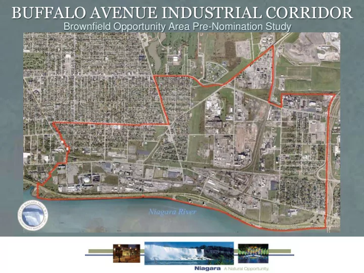
BUFFALO AVENUE INDUSTRIAL CORRIDOR Brownfield Opportunity Area Pre-Nomination Study A GENDA Brownfield Opportunity Area (BOA) Review Buffalo Avenue Preliminary BOA Characteristics Conceptual Plans Next Steps B ROWNFIELD


slide-1
SLIDE 1

BUFFALO AVENUE INDUSTRIAL CORRIDOR

Brownfield Opportunity Area Pre-Nomination Study

slide-2
SLIDE 2
  • Brownfield

Opportunity Area (BOA) Review

  • Buffalo Avenue

Preliminary BOA Characteristics

  • Conceptual Plans
  • Next Steps

AGENDA

slide-3
SLIDE 3

Step 1: Pre-nomination Study Investigation Step 2: Nomination Study Defined Area Detailed Analysis Step 3: Implementation Strategy & Site Assessments Pre-development

BROWNFIELD AREA OPPORTUNITY (BOA) PROGRAM

slide-4
SLIDE 4

Purposes

 Identified an area adversely

affected by brownfields

 Unsure of appropriate study

area

 Unknown existing conditions

– Land ownership – Potential contaminants

 Uncertain about

redevelopment potential

STEP 1: PRE-NOMINATION STUDY

slide-5
SLIDE 5

BOA PROGRAM BENEFITS

Advances projects to the marketplace

 Community support /

Partnerships

 Revitalization strategy  Transparency of environmental

conditions

 Grants  Project marketing

slide-6
SLIDE 6

BUFFALO AVENUE INDUSTRIAL CORRIDOR STEP 1: STUDY AREA ANALYSIS

Total Parcels in the PBOA: 3,000 Total PBOA Acreage: 1,800 Assessed Value: $450,000,000

slide-7
SLIDE 7

BUFFALO AVENUE INDUSTRIAL CORRIDOR STUDY AREA ANALYSIS

Existing Plans and Regulations Public Input Community Vision Economic & Demographic Data Environmental Data - Properties

Sustainable Redevelopment & Cleanup

slide-8
SLIDE 8

STUDY AREA ANALYSIS: ECONOMIC PROFILE

Population Estimate: 5,620 Housing Units: 2,800 55% Owner Occupancy Vacant Housing Units: 13% Traffic Counts - Daily NF Blvd 26,000 Buffalo Ave 10,000 Robert Moses 15,000

slide-9
SLIDE 9

STUDY AREA ANALYSIS: BROWNFIELD PROFILE (ACRES)

slide-10
SLIDE 10

STUDY AREA ANALYSIS

Brownfields, Underutilized, and Vacant Sites

VACANT by landuse (excluding Brownfields & Underutilized) Underutilized/Vacant Properties - Publicly Owned Underutilized/Vacant Properties - Privately Owned Brownfield Sites

slide-11
SLIDE 11

STUDY AREA ANALYSIS: Brownfield Site Scores

The Brownfield Scores are a preliminary estimate of the level of urgency in redeveloping a given site. Brownfield Scorecard Criteria:  Environmental Record (up to 3pts)  Environmental Perception (up to 5 pts)  Visibility from Roads (up to 3 pts)  Gateway Location (up to 5 pts)  Critical Node (up to 5 pts)  Historic Potential (up to 5 pts) Brownfield Sites with Score

3 - 5 6 - 8 9 - 10 11 - 12 13 - 15 16 - 18 19 - 21

Total possible Score = 26 pts

slide-12
SLIDE 12

COMMUNITY MEETINGS

Survey Results – Development Preferences

Maintain businesses, relocate some, redevelop 69% Mixed Use Development preferred 80% Traditional Development near waterfront/downtown 87% Suburban development near NF Blvd, LaSalle 77% Should developers be assisted with incentives? 91% Public Access to the Niagara is important? 96%

Baltimore Inner Harbor The Flats Cleveland

Models for Future Development

slide-13
SLIDE 13

CONCEPTUAL ZONES

Gray area represents heavy industrial parcels to be transitioned to new “clean” industries.

Heavy Industry remains only in the purple zones and is buffered

  • n all sides.

Residential (yellow) areas remain and existing green spaces as well as commercial areas (red) are enhanced.

slide-14
SLIDE 14

CONCEPTUAL PLAN PRINCIPLES

 Economic Development Potential

– Location

  • River
  • Transportation/Traffic
  • Amenities

– Reduction of Risk

  • Grants
  • Real Estate potential

 Community Input  Anchor Mentality  Gateways

slide-15
SLIDE 15

CONCEPTUAL PLAN

from Community Input

Illustrates the beginnings of redevelopment within 5 key areas.

Key corridors and linkages to water front

slide-16
SLIDE 16
  • 1. Adam’s Plant
slide-17
SLIDE 17
  • 1. Adam’s Plant

Transformer Building

slide-18
SLIDE 18

NY State Parks acquisition of the Adam’s Plant parcel.

Extend Acheson Drive to the water with new light industrial and commercial development.

Strengthen the public “face” along Buffalo Avenue – including both historic and new buildings.

  • 1. Adam’s Plant
slide-19
SLIDE 19
  • 2. Water Intakes Development
slide-20
SLIDE 20
  • 2. Water Intakes Development
slide-21
SLIDE 21

Round-about creates a formal gateway to the city and allows for signage, interpretation, and pedestrian friendly connections to water.

Hyde Park Blvd extends to water front with mixed use development on both sides.

Improve public “face” along Buffalo Avenue

  • 2. Water Intakes Development
slide-22
SLIDE 22
  • 3. LaSalle Expressway Extension
  • 3. LaSalle Expressway Extension
slide-23
SLIDE 23
  • 3. LaSalle Expressway Extension
slide-24
SLIDE 24

LaSalle Expressway provides a direct route to downtown

Existing residential areas remain undisturbed and well buffered.

Improve public “face” of heavy industry along LaSalle Expressway

  • 3. LaSalle Expressway Extension
slide-25
SLIDE 25
  • 4. Gateway Community and New Park
slide-26
SLIDE 26
  • 4. Gateway Community and New Park
slide-27
SLIDE 27
  • 5. Packard Rd & Niagara Falls Blvd

Intersection

slide-28
SLIDE 28
  • 5. Packard Rd & Niagara Falls Blvd

Intersection

slide-29
SLIDE 29

NEXT STEPS

 Revisions to Plans  Final Pre-nomination Study  Nomination Study Phase