a brief illustrated history of landscape and aboriginal
play

A Brief, Illustrated History of Landscape and Aboriginal Peoples in - PDF document

A Brief, Illustrated History of Landscape and Aboriginal Peoples in the Muskoka River Region Presenta on to the Lake of Bays Heritage Founda on Annual Mee ng by Mar n Cooper (Archaeological Services, Inc., Toronto) and Andrew


  1. A Brief, Illustrated History of Landscape and Aboriginal Peoples in the Muskoka River Region Presenta� on to the Lake of Bays Heritage Founda� on Annual Mee� ng by Mar� n Cooper (Archaeological Services, Inc., Toronto) and Andrew Stewart (Strata Consul� ng, Inc., Toronto) 15 August 2009 
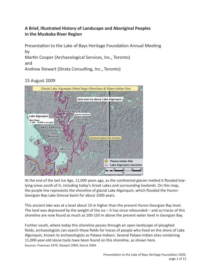
At the end of the last Ice Age, 11,000 years ago, as the con� nental glacier melted it fl ooded low- lying areas south of it, including today’s Great Lakes and surrounding lowlands. On this map, the purple line represents the shoreline of glacial Lake Algonquin, which fl ooded the Huron- Georgian Bay-Lake Simcoe basin for about 1000 years. This ancient lake was at a level about 10 m higher than the present Huron-Georgian Bay level. The land was depressed by the weight of the ice – it has since rebounded – and so traces of this shoreline are now found as much as 100-150 m above the present water level in Georgian Bay. Further south, where today this shoreline passes through an open landscape of ploughed fi elds, archaeologists can search these fi elds for traces of people who lived on the shore of Lake Algonquin, known to archaeologists as Palaeo-Indians. Several Palaeo-Indian sites containing 11,000-year-old stone tools have been found on this shoreline, as shown here. Sources: Freeman 1979, Stewart 2004; Storck 2004. Presenta� on to the Lake of Bays Heritage Founda� on 2009, page 1 of 13

  2. T his book is the best general account of the archaeology of the earliest se� lement of southern Ontario by people immediately a� er the Ice Age (11,000 – 10,000 yrs ago). The cover illustra� on shows people hun� ng caribou at a � me when the southern Ontario landscape was similar to subarc� c tundra -- lightly forested with spruce trees with open areas. The margin of the con� nental ice sheet was somewhere along, or just north of, the French River. Above the hunters in the illustra� on is a dis� nc� ve type of stone dart or spear point that Palaeo-Indians made during this period out of a rock called chert (like fl int), which was quarried from the Niagara Escarpment near Collingwood. These are the kinds of stone tools that archaeologists fi nd along the Lake Algonquin shoreline. Source: Storck 2004. Illustra� on (drawing by Ivan Kocsis) courtesy of UBC Press and the Royal Ontario Museum, used on the cover of Journey to the Ice Age by Peter Storck (UBC Press and Royal Ontario Museum, 2004) In the Muskoka region, the shoreline is less dis� nct; ploughed fi elds, where archaeologists can usually clearly see if ar� facts are present, are scarce. You can, however, see traces of the shoreline east of Highway 11. Because sediment in this area of the Canadian Shield is generally thin, these traces tend to be only weakly visible. On this map, you can see that Lake of Bays represents a former inlet of glacial Lake Algonquin and that Peninsula and Fairy Lakes formed the mouth of this inlet. Sources: Bajc 1994; Bajc and Henry 1991; Long 1989. Presenta� on to the Lake of Bays Heritage Founda� on 2009, page 2 of 13

  3. Not all Palaeo-Indian sites are found south of Lake Simcoe. This spear point from the Late Palaeo-Indian period comes from a site located on the Algonquin shoreline in the region of the Lake of Bays inlet. Source: Allen 2002. In addi� on to glacial lake shorelines, other natural features are of interest to archaeologists. The Lower Oxtongue River fl oodplain on Lake of Bays formed over the last 10,000 years by the fl ooding and meandering ac� on of the river channel and the accumula� on of sand and mud in its fl oodplain. This is the kind of se� ng where archaeological sites typically get buried and preserved. Further upstream, to the right, is a record of older fl ooding and deposi� on by glacial outwash sands at the end of the Ice Age. To the west and north of the lower Oxtongue River are shallow-water sands deposited in glacial Lake Algonquin. Sources: Ontario Ministry of Natural Resources Natural Heritage Informa� on Centre, Natural Areas Information, http://nhic.mnr.gov.on.ca/MNR/nhic/areas.cfm; Bajc 1994; Bajc and Henry 1991; Geddes and McClenaghan 1984; Ontario Geological Survey 2003. Presenta� on to the Lake of Bays Heritage Founda� on 2009, page 3 of 13

  4. The level of Lake Algonquin fell dras� cally at the end of the Palaeo-Indian period, to well below present Georgian Bay levels. Water levels in the Great Lakes only reached their modern levels (which are s� ll fl uctua� ng within a narrower range) between about 4000 and 5000 years ago. At this � me, during the period that archaeologists refer to as the Late Archaic (about 4500 – 2900 years ago), people established camps on or near shorelines and traveled along river and lake routes that are essen� ally familiar to us today (disregarding the changes to hydrology brought about by canals and dams built in the 19 th and 20 th centuries). Sources: Allen 2002; Ellis et al. 1990; Karrow and Warner 1990; Long 1989; The Archaeology of Ontario: h� p:// www.ontarioarchaeology.on.ca/summary/contents.htm. Presenta� on to the Lake of Bays Heritage Founda� on 2009, page 4 of 13

  5. The mouth of the Severn River, at the southwest edge of the Muskoka Lakes region, is known as an important loca� on in central Ontario during various periods, including especially the Middle Woodland period (AD 0 – 500), a � me when ceremonial mounds were built across Ohio and in many river valleys of the Great Lakes region, including the Trent River valley. This image is an example of a collec� on of ar� facts and raw materials from a site that was probably a Middle Woodland ceremonial mound removed by co� age development of this built-up area during the mid-20 th century. Sources: Allen 2002; The Archaeology of Ontario: h� p://www.ontarioarchaeology.on.ca/ The materials and ar� facts in the last slide were imported from all over the Great Lakes region during the Middle Woodland period (possibly even from Labrador) via routes of travel following major rivers and lakes. Sources: Allen 2002; Spence et al. 1990. Presenta� on to the Lake of Bays Heritage Founda� on 2009, page 5 of 13

  6. This Petroglyph site located on Sparrow Lake was men� oned but not visited by Dewdney during his extensive documenta� on of pictograph sites in Ontario. It was relocated by ASI during the Heritage Master Plan for Muskoka in 1993. To date, it is the only example of aboriginal rock art in the Muskoka District. Sources: ASI 1994, Dewdney and Kidd 1967 This map shows some of the Iroquoian- and Algonquian-speaking peoples and na� ons in central Ontario that were recorded by the Jesuits who were living among the Huron in the Orillia-to-Midland area during the fi rst half of the 17 th century. Source: Heidenreich 1987. Presenta� on to the Lake of Bays Heritage Founda� on 2009, page 6 of 13

  7. Picking up the story from the historical record in the 19 th century, it is not known whether the Anishinaabeg, the aboriginal peoples living in the eastern Georgian Bay-Muskoka region during the late 18 th and early 19 th century (who eventually se� led at places like Rama, Parry Island and Beausoleil and Chris� an Islands), were directly descended from some of the groups shown in the last slide (e.g., the Sagahanirini in western Muskoka), or whether these early 19 th century peoples were part of a southeastward movement of people known today, collec� vely, as the Anishinaabeg who, following the dispersal of the Huron in 1649, moved down from the north shore of Lake Huron and Lake Superior during the late 17 th century. Western Muskoka came to be occupied by families affi liated with the Muskoka band, who were permanently based at Coldwater, then moved to Beausoleil Island (1842), then to Chris� an Island (1856). Southern and eastern Muskoka was used by families – with names like Yellowhead and Bigwin -- from Rama (now Mnjikaning). Families based at places like Rama and Beausoleil Island in the winter would travel to the Muskoka region in spring to establish gardens as well as to hunt and trap (deer, bear, muskrat, beaver) and trade in the area around their se� lements. James Bigwin (Bigwind) and Chief William Yellowhead (Mesquakie), who dis� nguished themselves in the War of 1812 (at the Ba� le of York, 27 April, 1813), were from Rama. Bigwin had his se� lement on Bigwin Island In Lake of Bays and at Cedar Narrows (today’s Dorset) leading into Trading Lake. Yellowhead had a se� lement at Kehkapekon (Bracebridge portage). Menominee, well known to mid-late- nineteenth-century Muskoka se� lers, hunted between Lake of Bays and Mary Lake, eventually establishing a farm at Menominee Lake before moving to Parry Island in the 1870s. Sources: ASI 1994; Malcomson 2008 Presenta� on to the Lake of Bays Heritage Founda� on 2009, page 7 of 13

  8. As shown in this map of his route, John Bigwin (son of James) would travel during spring, for 45 years, from Rama down the Severn River through Washago to Morrison Lake, through Lag Lake, to Muskoka Bay, up the South Branch of the Muskoka River to Lake of Bays, ending at Cedar Narrows and Trading Lake where he had his se� lement and garden. Source: ASI 1994 Chief John Bigwin Source: Avery 1974:4 Presenta� on to the Lake of Bays Heritage Founda� on 2009, page 8 of 13

Download Presentation
Download Policy: The content available on the website is offered to you 'AS IS' for your personal information and use only. It cannot be commercialized, licensed, or distributed on other websites without prior consent from the author. To download a presentation, simply click this link. If you encounter any difficulties during the download process, it's possible that the publisher has removed the file from their server.

Recommend


More recommend