1 RIVER SERPIS Elevation above thalweg representing Tolerance to - - PDF document

1
SMART_READER_LITE
LIVE PREVIEW

1 RIVER SERPIS Elevation above thalweg representing Tolerance to - - PDF document

Inst. of Research for Integrated Managementof Coastal Zones PRESENTATION (vegetation & Flow studies): FRANCISCO MARTNEZ CAPEL DOCTOR INGENIERO DE MONTES - Study in River Mijares (3 regulated sites) PhD, FORESTRY ENGINEERING - Study in


slide-1
SLIDE 1

1

PRESENTATION (vegetation & Flow studies):

  • Study in River Mijares (3 regulated sites)
  • Study in River Serpis (1 regulated site)
  • Study for comparison between 2 rivers
  • Advanced studies in River Serpis: Methods

FRANCISCO MARTÍNEZ CAPEL DOCTOR INGENIERO DE MONTES PhD, FORESTRY ENGINEERING

  • DPTO. INGENIERÍA HIDRÁULICA Y MEDIO AMBIENTE

UNIVERSIDAD POLITÉCNICA DE VALENCIA ADDRESS: E.P.S. GANDIA (UNIVERSIDAD POLITÉCNICA DE VALENCIA)

  • Ctra. Nazaret-Oliva s/n

GANDIA, 46730 VALENCIA. SPAIN.

Ph.Nº: (+34)-96-2849300 E-mail: fmcapel@dihma.upv.es Web: //personales.gan.upv.es/fmcapel

  • Inst. of Research for Integrated Managementof Coastal Zones

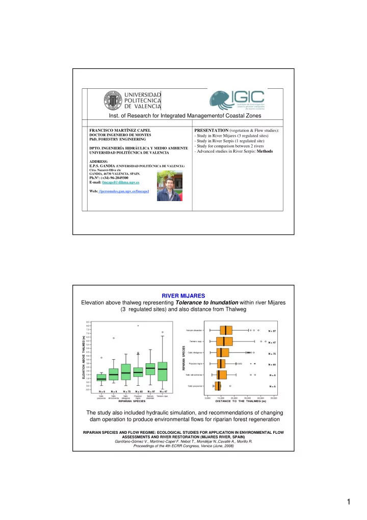
RIVER MIJARES Elevation above thalweg representing Tolerance to Inundation within river Mijares (3 regulated sites) and also distance from Thalweg

RIPARIAN SPECIES AND FLOW REGIME: ECOLOGICAL STUDIES FOR APPLICATION IN ENVIRONMENTAL FLOW ASSESSMENTS AND RIVER RESTORATION (MIJARES RIVER, SPAIN) Garófano-Gómez V., Martínez-Capel F. Nebot T., Mondéjar N.,Cavallé A., Morillo R. Proceedings of the 4th ECRR Congress, Venice (June, 2008)

N = 6 N = 47 N = 65 N = 8 N = 75 N = 97 N = 97 N = 47 N = 75 N = 65 N = 8 N = 6

The study also included hydraulic simulation, and recommendations of changing dam operation to produce environmental flows for riparian forest regeneration

slide-2
SLIDE 2

2

RIVER SERPIS Elevation above thalweg representing Tolerance to Inundation within river Serpis (1 regulated site) and also distance from Thalweg

Phragmites australis (PH), Salix atrocinerea (SA), Populus alba (PA), Nerium oleander (NO), Crataegus monogyna (CR), Populus nigra (PN) GESTIÓN DEL AGUA PARA LA CONSERVACIÓN DE LAS RIBERAS DEL RÍO SERPIS Report for CEIC Alfons el Vell (Ayuntamiento de Gandia), dic-2008

The study incorporated two field work approaches: sampling by transects and sampling by habitat patches (finished recently), in order to recommen changes in regulated flows Functional groups about tolerance could be derived from these data for vegetation model RIB-Av

DISTRIBUTION PATTERNS OF RIPARIAN SPECIES IN RELATION TO CHANNEL BED IN TWO MEDITERRANEAN RIVERS.

  • V. Garófano-Gómez, F. Martínez-Capel, F. Francés

7th internat. Symposium on ecohydraulics. Concepción, Chile (January 2008)

RIVERS SERPIS & MIJARES

Comparison of elevation above thalweg representing Tolerance to Inundation

(within rivers & transferability across rivers)

Serpis Mijares-1 Mijares-2 The study allowed the comparison among reaches, for 3 species and the assessment of transferability of height above channel thalweg as a useful parameter in vegetation models

slide-3
SLIDE 3

3

VEGETATION ANALYSIS IN THE RIVER SERPIS (from large dam to the sea) principal coordinates analysis with abundance matrix (Braun-Blanquet transformed) in 16 study segments

GESTIÓN DEL AGUA PARA LA CONSERVACIÓN DE LAS RIBERAS DEL RÍO SERPIS Report for CEIC Alfons el Vell (Ayuntamiento de Gandia), dic-2008

Group 1 Group 2 Group 3

M

  • d

e r a t e s t a t e Good state Bad state

Overview of study reach for hydraulic simulation: transects and iron rods (red)

VEGETATION ANALYSIS IN THE RIVER SERPIS Hydraulic model 1-dim (running RHYHABSIM, Jowett 1989)

  • 25 transects
  • Only 11 transects were used to study vegetation-flow relationships
slide-4
SLIDE 4

4

VEGETATION ANALYSIS IN THE RIVER SERPIS

Location of the Transects and Hydrometry

  • Study of great detail with representative reach
  • All transects with same datum (elevation reference), this allow the hydraulic

modelling based on Rating Curves and also water surface profile modelling

V i

Vi ∆wi Di

Cross-section or transect Divided into “cells” or pieces Of section where we measure

Beginning End Modified from FIREMON (2003), in Harris et al. (2005).

VEGETATION ANALYSIS IN THE RIVER SERPIS

Vegetation Survey by habitat patches

Habitat patch Biological Assessment:

  • Species Abundances
  • Veget. cover
slide-5
SLIDE 5

5

VEGETATION ANALYSIS IN THE RIVER SERPIS

Soil Sampling

Necessary to obtain parameters

  • f RIB-Av (thickness of capillary fringe)

To estimate in Laboratory:

  • Organic matter content (%)
  • Texture

Level (m) Flow (m

3/s)

Cross-section: SEC-24

0.00 0.25 0.50 0.75 1.00 1.25 10.40 10.56 10.72 10.88 11.04 11.20

Rating types Survey stage and flow Gaugings Critical Rating SZF Rating: Q = 2.35 x ( H - 10.375 ) ^ 2.10 Best SZF Rating: Q = 1.70 x ( H - 10.216 ) ^ 2.76 Hydraulic Rating: N = 0.073 x Q ^ -0.02

Elevation (m) Distance (m)

Reach : SERPIS~1

50 100 150 200 250 9.2 9.5 9.9 10.2 10.5 10.9 11.2

VEGETATION ANALYSIS IN THE RIVER SERPIS

Hydraulic Modelling

Based on Rating Curves (flow-water elevation)

Plan B Based on Water Surface Profile Modelling (WSP) (similar to HEC-Ras)

Transects where water surface profile has a break, hydraulic controls,chenge of mesohabitat, etc.

slide-6
SLIDE 6

6

VEGETATION ANALYSIS IN THE RIVER SERPIS

Growth curves

VEGETATION ANALYSIS IN THE RIVER SERPIS

Growth curves

N=34 N=25

slide-7
SLIDE 7

7

VEGETATION ANALYSIS IN THE RIVER SERPIS

Data Processing

  • Getting/calculating daily flow records in site
  • Calculating time series of Water Surface Elevation at each transect
  • Associating such time series to the different habitat patches
  • bserved (since the time we estimate this patch appeared –max.

tree age-)

  • Estimating hydrological parameters associated to each habitat

patch (succession faces): flow rate that started succession, inundation frequency, time of continuous inundation, others.

  • Estimation of necessary flow to inundate riparian forest area, and

flow recession rate for forest regeneration (based on internat. Studies or local studies) management recommendations

  • End of Previous Works -

For Definition of Field Methods we need to define BEFORE the arquitecture of the model (input-output)

Planning Field Work - RIPFLOW

Flow direction Transect-1 (downstream) Transect-n (upstream)