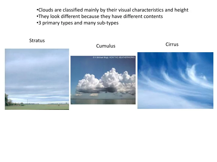
SLIDE 1
- Clouds are classified mainly by their visual characteristics and height
- They look different because they have different contents
- 3 primary types and many sub-types
Stratus Cumulus Cirrus
SLIDE 2 Stratus Clouds
Characteristics:
- Can be at any altitude – stratus just means that they form a horizontal layer
- They are often at low altitude in bad weather (nimbostratus)
- Fog is a stratus cloud hugging the ground
- They are formed by weak, but widespread vertical motion (~10 cm/s)
- The are made of a moderate density of cloud drops , LWC~.1 g/m3
- Cumulus or cirrus can also form a layer (Stratocumulus and cirrostratus)
SLIDE 3 Cumulus Clouds
Characteristics:
- Can be at any altitude – cumulus means “heaping”
- They develop more vertically than horizontally.
- When they form rain they become cumulonimbus
- They are formed by strong vertical motion, sometimes 25 m/s updrafts
- Strong vertical motion and cumulus clouds result from free convection
that comes from instability
- If that vertical motion is deep enough, ice can form in upper part of the cloud
- Ice crystals and strong motion -> charge separation ->lightning
- They have the greatest LWC: from .5 to 4 g/m3 depending of updraft rate
SLIDE 4 Cirrus Clouds
Characteristics:
- Are composed of tiny ice crystals, not liquid cloud drops
- Usually form only when T< -25 C
- They are formed by weak vertical motion (~5 cm/s)
- The are made of a small density of ice crystals , IWC~.05 g/m3
- Sometimes generated by jet exhaust (contrail)
- Often initiated as anvils of cumulus clouds striking the tropopause-lid
- Important effects due to widespread radiative impact
SLIDE 5
Cloud Height
Cloud height Cloud types
Low (below 2 km, 6500 ft) Fog Stratus Nimbostratus Stratocumulus Stratus fractus Cumulus humulis Mammatus Funnel Middle(2-6 km, 6500-20000ft) Cumulus humulis Cumulus mediocris Stratocumulus Altostratus Altocumulus High (6+ km, 20000 ft+ ) Cirrus Cirrostratus Cirrus uncinus/fibratus Pileus cloud Large vertical span Cumulus castellanus Cumulus congestus Cumulonimbus
SLIDE 6 http://apollo.lsc.vsc.edu/classes/met130/notes /chapter5/graphics/drop_cloud_ccn.gif CCN: Cloud Condensation Nuclei
- Needed to turn supersaturation into liquid drops (a site is needed for condensation)
- This is referred to as “drop nucleation” – a big uncertainty in the science of clouds
- CCN are preferentially hydrophillic
- Can be composed of dust, bacteria, pollen, pollutants, acid drops, salt, and others
- Ice nuclei have slightly different characteristics
SLIDE 7 m =
“net” molecules added molecules impinging - molecules vaporizing
Will make it in Made it out Will be rejected
m =
+
~20 um radius
Vapor deposition into water drops
SLIDE 8
- Average coefficients help determine net mass growth rate
- Relative local coefficients determine habit type
- Local coefficient is a function of temperature and moisture density
- Mechanism for coefficient temperature function is an enduring mystery
- Mechanism of incorporating incident molecule into lattice is also unknown
+
On the way out Cleared for landing (condensation) Taking off (sublimation) Brief layover Taxiing to lattice (surface diffusion) Actively growing terrace
2D Nucleation
Vapor deposition onto ice surfaces
SLIDE 9 Bergeron-Findeison Process
- The saturation vapor over water is greater than ice (see phase diagram)
- This is caused by the greater difficulty in breaking 100% vs 80% of H-bonds
- Vapor tries to move from high concentration -> low concentration (law of diffusion)
- Thus, when water and ice surfaces are nearby, the vapor moves from high concentration
(water surface)->lower concentration (ice surface), allowing ice to grow as water evaporates
- This is the major form of ice crystal growth in mixed-phase clouds
- This process contributes to many stages of the precip. process
SLIDE 10
Little drops->Big drops: Collision-Coalescence
SLIDE 11
Riming->graupel->Hail
SLIDE 12
Frozen precip. scenarios
SLIDE 13
Crystals photographed in cirrus clouds by aircraft-borne probe
SLIDE 14
Witches concoct a brew to summon a hailstorm.
“After the bomb, Dad came up with ice” – Kurt Vonnegut, Cat’s Cradle, on the invention of “ice-nine”.
Weather Modification and cloud seeding
SLIDE 15