speers road corridor study draft policies
play

Speers Road Corridor Study Draft Policies Livable Oakville - PowerPoint PPT Presentation

Speers Road Corridor Study Draft Policies Livable Oakville (Official Plan) Council Sub Committee September 11, 2017 Overview 1) Background 2) Draft Policy 3) Next Steps & Discussion Image source: Google Maps Background


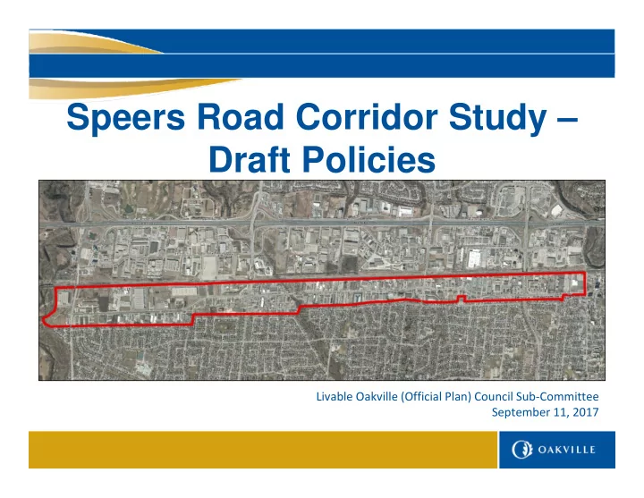
  1. Speers Road Corridor Study – Draft Policies Livable Oakville (Official Plan) Council Sub ‐ Committee September 11, 2017

  2. Overview 1) Background 2) Draft Policy 3) Next Steps & Discussion Image source: Google Maps

  3. Background • Livable Oakville Plan 26.4.2 The corridor located along Speers Road should be further studied to confirm long-term land uses and opportunities for intensification suitable for this area. STUDY AREA North: Railway tracks East: Kerr Street South: Boundary between employment area and residential area West: Bronte Creek Image source: Google Maps

  4. Background • May 2015 – Launch of Official Plan Review • November 2016 – LOCS – Employment & Commercial Review (consultant’s report) • March 2017 – LOCS – Speers Road Corridor Study Since then…

  5. Background June 2017 – Urban Structure Review – PDC Public Meeting *Upcoming* September 26, 2017 – Urban Structure Review – PDC Recommendation Report

  6. Background July 2017 – New Provincial Plans (e.g. Growth Plan 2017)

  7. Background July/August 2017 – ATMP approved

  8. Background September 2017 (today!) – LOCS – Employment & Commercial Review (staff directions) Excerpt from Appendix A of Employment Commercial Review Staff Report (LOCSC) September 11, 2017)

  9. Draft Policy Basis • Speers Road Corridor Study report findings and policy directions; • Input from the Livable Oakville Council Subcommittee; • Ongoing review of emerging and recently approved policies including: Provincial Growth Plan, Urban Structure, Employment & Commercial Review, and transportation related projects; and, • Consultation with town departments, Halton Region, and initial business and property owner meetings.

  10. Draft Policy Format • Special Policy Area (Section 26 of Livable Oakville) • Goal, Objectives, Development Concept (three districts), Functional Policies, Land Use Policies, and Implementation Policies Bronte Creek – East of Third Line – Fourth Line – Fourth Line East of Third Line Kerr Street

  11. Draft Policy Goal and Objectives Goal The Speers Road Corridor will support the town’s urban structure as an intensification corridor and transit priority corridor which will be a multi modal, transit supportive, employment area where a wide range and mix of business and economic activities can thrive. Objectives a) Recognize the unique context of the Speers Road Corridor employment area as an employment mixed use corridor b) Support the role of Speers Road as an intensification corridor c) Support the role of Speers Road as a transit priority corridor

  12. Draft Policy Functional Policies Transportation Policies with respect to the evolving transportation requirements for Speers Parking Policies for how parking should be accommodated, including driveways Urban Design Policies for how new development should be designed – compatible and transit-supportive Accommodating Intensification Policies for how we can accommodate additional employment growth Minimum Density A policy to establish a minimum employment density target with the Region

  13. Draft Policy Land Use Policies • Major retail uses are not permitted • A new defined term of “arterial commercial” uses subject to a maximum size threshold • Expanding the range of permitted uses within all land use designations found along the corridor including these additional uses: Business Employment Industrial Business Commercial • Indoor sports facilities • Office • Light industrial uses • Indoor places of entertainment • Hotels • Arterial commercial uses • Arterial commercial uses • Public halls • Indoor sports facilities • Service commercial uses • Indoor places of entertainment • Indoor places of entertainment • Accessory retail • Major office within 500 metres of Bronte Station • No new outdoor storage adjacent to residential

  14. Draft Policy Implementation Policies • New criteria to evaluate consent applications Phasing and Transition Policies • Allow legal existing uses • Allow reductions to the minimum building height of 2 storeys for certain uses such as warehousing or manufacturing • Allow changes a change in use, additions and expansions of existing buildings which are not subject to the minimum building height • Protection for Bronte Go Station Major Transit Station Area – future study to be undertaken Programs and Initiatives • Linking land use policies with economic development strategies • Community improvement plans for brownfield redevelopment • Updates in consultation with the Halton Region including the MCR

  15. Next Steps & Discussion  Q1: 2017 – Directions Report (March 20, 2017 LOCS)  Q3: 2017 – Draft Policy Changes / Public Consultation  Q4: 2017 – Statutory Public Meeting (Draft OPA at PDC)  Q1: 2018 – Recommendation Meeting (OPA at PDC) Discussion, Comments & Questions

Download Presentation
Download Policy: The content available on the website is offered to you 'AS IS' for your personal information and use only. It cannot be commercialized, licensed, or distributed on other websites without prior consent from the author. To download a presentation, simply click this link. If you encounter any difficulties during the download process, it's possible that the publisher has removed the file from their server.

Recommend


More recommend