
SLIDE 1
DEL-MAR ENERGY PATHWAY PROJECT- SOMERSET EXTENSION DEL-MAR ENERGY - - PowerPoint PPT Presentation
DEL-MAR ENERGY PATHWAY PROJECT- SOMERSET EXTENSION DEL-MAR ENERGY PATHWAY PROJECT Eastern Shore Natural Gas is an interstate pipeline company regulated by the Federal Energy Regulatory Commission (FERC) and has been transporting natural
▪ Eastern Shore Natural Gas is an interstate pipeline company regulated by the Federal Energy Regulatory Commission (FERC) and has been transporting natural gas to the Eastern Shore of Maryland for over 60 years ▪ A Certificate of Public Convenience and Necessity was granted by FERC in December 2019 (CP18-548-000) ▪ The Somerset Extension is a portion of the overall Del-Mar Energy Pathway Project, and is the
in Maryland
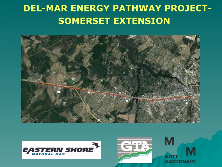
▪ Location: Salisbury, Fruitland, and Eden areas of Wicomico and Somerset Counties ▪ Waterbody: South Prong Wicomico River, Tonytank Pond, Passerdyke Creek, and an unnamed tributary of the Wicomico River ▪ Applicant: Eastern Shore Natural Gas Company (ESNG) ▪ Engineer: Mott MacDonald ▪
Associates, Inc. (GTA) ▪ Purpose: Extension of ESNG’s existing pipeline system from Salisbury, MD to Eden, MD in order to meet market demand in Somerset County
▪ Approximately 6.8 miles of 10-inch diameter mainline pipeline extension ▪ The route will be approximately 91% within existing rights-of-way
◆ Three proposed routes were evaluated ◆ The proposed route is the preferred alternative ◆ The proposed route is largely within existing road
◆ 1 tidal waterbody crossing, 3 nontidal waterbody
◆ To minimize impacts, the limit of disturbance was reduced from
the typical 100-foot width to a 75-foot width within the wetland and stream crossings